

Watershed Blog
Watershed Awareness - it's all right here
2023 - Watershed Programs Blog Series: Preserving Rural Communities Through USDA NRCS Watershed Conservation Work

Dam Good Work
The first of a series of blogs that highlight watershed conservation work being done throughout the nation through NRCS Watershed Programs.
DAM GOOD WORK
Since its inception in 1935, the Soil Conservation Service, renamed the Natural Resources Conservation Service (NRCS) agency in 1994, has assisted communities and local sponsors to design and build over 29,000 dams in the United States. This is approximately one-third of the dams in the national inventory of dams. This includes over 11,850 dams that were constructed in cooperation with local project sponsors of dams in watershed projects in 47 states. This year commemorates the agency’s continued efforts to preserve our watersheds and rehabilitate our watershed infrastructure.
Many today are unfamiliar with the role watersheds play and are unaware of the dams that protect their community. They may never have had to survive a major flood after a torrential rain or see their crops and livelihood swept downstream. Dams were built to be silent sentinels and a testament to their function. However, this can provide a false sense of security as aging dams and watershed infrastructure require ongoing oversight and maintenance to ensure they continue to save lives and protect property. Most of the dams were designed to protect agricultural areas, but after their construction, many houses and businesses were built downstream of the dams. So now many dams protecting human life do not meet current safety standards.
Following, are upcoming anniversaries that highlight and honor the dam good work being performed by local sponsors and NRCS in our communities:
CLOUD CREEK SITE 1 – OKLAHOMA – 75TH ANNIVERSARY – JULY 8TH, 2023
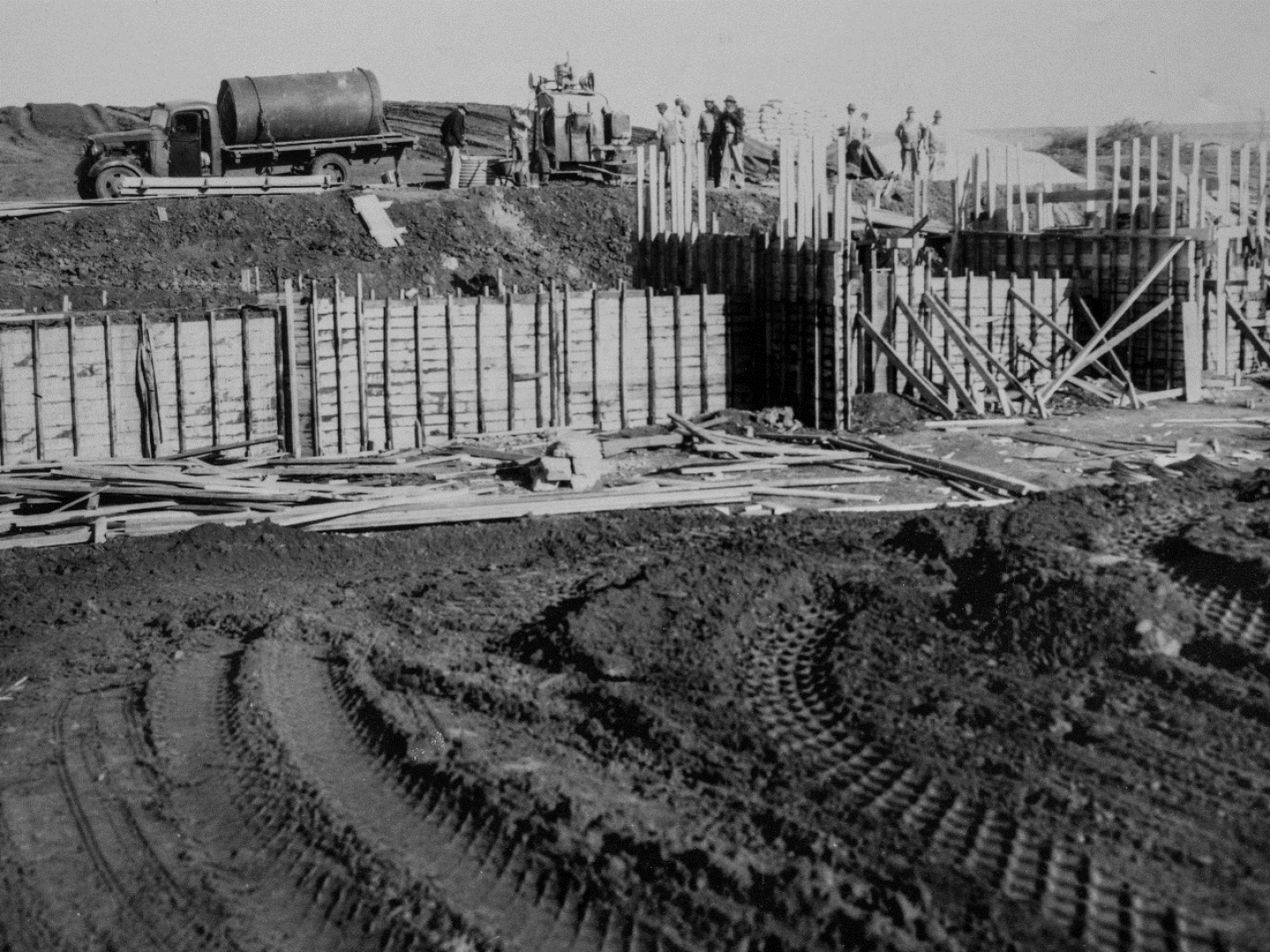
Construction work on first upstream watershed dam – Cloud Creek Site 1 – photo credit: NRCS
Cloud Creek Site 1 was the nation’s first upstream watershed dam. Constructed as an earthen dam in 1948, this year marks its 75th anniversary. As one of eleven pilot projects that were undertaken when the Flood Control Act of 1947 was enacted by Congress, Cloud Creek was the first dam to be completed. The project required securing the necessary rights to build the upstream dam on private property within Washita Watershed near Cordell, Oklahoma, that benefitted the agricultural areas downstream. The pilot project was a success and Congress followed thru with the Watershed and Flood Prevention Act of 1954 legislation (PL-566) expanding the opportunity for flood control structures to be constructed throughout the nation. Between 1947 and 2011 over 2,100 dams were built in Oklahoma. Sixteen hundred of the dams are more than 50 years old.
The dedication of Cloud Creek Site 1 in 1948 attracted over 10,000 people. Today, many passers-by would not even know it exists. The dam resides on private land as do more than 98% of the dams within the contiguous United States. Designed and built by NRCS, managed and maintained by local sponsors, dams are constructed in the best location to do the job intended. Landowners willingly provided access during those initial years, understanding the importance to the surrounding community and to future generations.
Today, the 75-year-old dam, maintained by the Washita County Conservation District, continues to perform as designed as flood control, water supply, recreation, wildlife habitat and to improve water quality to the communities it serves. Its overarching purpose is to protect lives and property.
COON CREEK WATERSHED – 90TH YEAR CELEBRATION OF THE FIRST FEDERAL WATERSHED PROJECT – SEPTEMBER 9TH, 2023

From left to right, John Bollinger, a farmer and planner with the Soil Conservation Service at Coon Valley, Dr. Hugh Bennett, retired chief of the U.S. Soil Conservation Service, Marvin Schweers, Wisconsin state conservationist, and Herbert Flueck, Minnesota state conservationist – July 19th, 1955.
In 1933, the Coon Valley Watershed in Wisconsin, became a template for modern day soil conservation practices. Collaborative efforts between prevailing conservationists, University of Wisconsin soil experts, and the Soil Erosion Service (renamed the Soil Conservation Service and now the Natural Resources Conservation) worked together to implement conservation practices designed (in theory) to rehabilitate the watershed and provide a sustainable future. As local conservationist Aldo Leopold stated at the time, “Coon Valley, in short, is one of the thousand farm communities which, through the abuse of its originally rich soil, has not only filled the national dinner pail, but has created the Mississippi flood problem, the navigation problem, the overproduction problem, and the problem of its own future continuity.” The same scenario echoed throughout the Midwest.
SES (now NRCS) had to prove that soil conservation measures achieved two main objectives: increase income for farmers and conserve the soil. Farmers signed a 5-year cooperative agreement, and the government provided the materials and additional labor. Terracing, strip-farming, replanting former wooded hillsides, converting pastures back to forests, creating wildlife habitat, constructing dams, and planting steep slopes with trees and sod were measures employed to prevent erosion and gully formation. Teaching farmers to plow along contour lines to slow runoff proved to have an important and long-lasting effect. By 1937, over 43,000 acres in the Coon Creek watershed were under sustainable soil conservation management.
Today, Coon Creek Watershed is being challenged and taking the lead again. In the ‘30s the Dust bowl drove conservation efforts. Today, additional conservation practices are being introduced to help towns and farmers build towards a resilient future.
DOLLAR RIDGE EMERGENCY WATERSHED PROTECTION (EWP) PROJECT – UTAH – 5th Year Anniversary – July 1st, 2023

Photo credit: Jones and DeMille Engineering
On July 1, 2018, east of Strawberry Reservoir, the Dollar Ridge Fire began and grew fueled by gusty weather conditions that forced more than 1,000 residents from their homes. The wildfire was finally contained one month later after burning more than 68,000 acres. Two storms followed creating debris flows and flooding due to burn scars that inhibited the land’s natural ability to absorb water. Water quality, water storage and devasting damage to the Strawberry River were the major resource concerns that drove rehabilitation efforts.
Five years later, the Emergency Watershed Protection (EWP) project is a testament to utilizing sustainable and economic design to recycle timber, debris, soil, and rock deposits. Large timbers washed into the floodplain were used to decrease the use of riprap and emulate nature’s best watershed technology – beaver dams. Post-assisted log structures (PALS) are a unique and unconventional application that was used to increase aquatic and wildlife habitat while supporting sediment deposits to slow the flow.

Photo credit: Jones and DeMille Engineering
In February 2023, the Dollar Ridge EWP Project conservation efforts received an American Council of Engineering Companies (ACEC) Engineering Excellence Honor Award in the Water Resources category. Through NRCS EWP funding assistance, innovative design and construction techniques, the goals of restoring safe access and protecting property from future flooding were achieved. Utah’s Duchesne and Wasatch Counties worked with NRCS, the Utah Division of Wildlife Resources (UDWR), the Utah Reclamation Mitigation & Conservation Commission, the Ute Tribe, and contracted company Jones & DeMille Engineering (JDE), among others to accomplish the huge undertaking.
NRCS Floodplain Buyouts Offer Options for Flood Prone Lands in West Virginia
While beautiful, parts of West Virginia’s rugged landscape are especially flood prone. There are towns in these floodplains where residents are at risk of losing property, life savings, their lives due to flash floods.
The Natural Resources Conservation Service (NRCS) Watershed Programs has the authority to purchase flood-prone homes through voluntary floodplain buyouts to keep homes from being rebuilt in flood-prone areas. This lessens the effects of future disasters and potentially saves lives, property, and money. “Prior to receiving help to weather flooding events, residents would have to ride out the storms, risk losing their property and life savings,” says Pam Yost, NRCS State Economist. “Today, there are options. The Natural Resources Conservation Service has one of the best programs to offer relief to towns experiencing frequent flooding.” A home’s appraisal is based on its pre-flood disaster value ensuring that homeowners can recover their investment and be made whole in the event of a devastating flood. NRCS works with local sponsors (typically local government agencies, tribal organizations, or conservation districts) to purchase properties when it proves to be the best option to prevent future flood damage.
For example, McDowell County’s Elkhorn Creek/Tug Fork River Watershed is one of those vulnerable, flood prone areas.
Residents experienced repeated flooding due to steep topography, rapid runoff, narrow floodplains, and concentrated residential development in the valleys. In the last four decades, there have been at least 17 federal disaster declarations in the county.
Traditional flood mitigation methods such as dams, floodwalls, stream realignment, dikes or other structural options are too expensive or ineffective. So, thirty McDowell County homeowners were offered voluntary buyouts and twenty-seven accepted.
“This project is a shining example of the undaunted effort and collaboration of the community along with NRCS to help their towns not only survive but thrive. No one wants to lose their home or leave friends and family – these voluntary buyouts offer a lifeline when there isn’t a viable alternative,” said Steve Baker, Acting NRCS State Conservationist, West Virginia.
Many problems attributed to constant flooding are resolved through the voluntary buyouts including reduced home damage, less flood debris and lower cleanup costs, improved water quality, resident safety, reduced emergency services, improved potential for recreational use and improved stream habitat and watershed resiliency.
The bedrock of NRCS Watershed Programs is to safeguard lives and property. The Emergency Watershed Protection Program has streamlined the process to make it even easier for communities to consider buyouts as an option. EWP assistance begins with a request from the local sponsor – once it is determined that the project is eligible – funds can be allocated as funds remain available. For further information, contact your local NRCS EWP Program Manager.
NRCS, Forest Service Partner to Expedite Watershed Infrastructure Projects
USDA’s Natural Resources Conservation Service (NRCS) and the USDA Forest Service are taking steps to get to work faster on watershed infrastructure projects in national forests and neighboring communities.
This is especially important following natural disasters like wildfire, as it enables NRCS to cooperate with the Forest Service on Emergency Watershed Protection Program projects. These projects help to relieve imminent threats to life and property caused by floods, fires, windstorms and other natural disasters that impair a watershed.
“When it comes to disaster recovery, speed is everything,” said NRCS Chief Terry Cosby. “Our continued partnership with the Forest Service will enable us to better respond to natural disasters and help prevent impacts from future ones. It is unavoidable that wildfires will burn across areas with a patchwork of land ownership, including National Forest System lands, and it is essential that this work can be completed on all of those lands without delay.”
The Emergency Watershed Protection Program helps with projects that:
- remove debris from stream channels, road culverts and bridges;
- reshape and protect eroded streambanks;
- correct damaged or destroyed drainage facilities;
- establish vegetative cover on critically eroding lands;
- repair levees and structures;
- repair certain conservation practices; and,
- purchase floodplain buyouts.
NRCS and the Forest Service actively collaborate on many projects where the landscape shifts from farmland to forest or federal to private. A recent memorandum of understanding defines the role each agency will perform, provides clarity on assistance each will provide and enable a faster response in times of need.
Specifically, this interagency partnership streamlines funding and coordinates project management so that watershed protection can immediately be implemented following a wildfire or other natural disaster.
“This agreement strengthens the collaborative relationship between the two agencies and enables greater coordination in post-disaster recovery efforts to more rapidly provide flood and soil erosion protection for communities adjacent to national forests and grasslands,” said Forest Service Chief Randy Moore. “As we experience increased natural disasters, as well as larger and more destructive wildfires, it is essential to modernize our post-disaster recovery programs and partnerships to more effectively serve impacted communities. This is one more step in that direction with our close partners at NRCS within the U.S. Department of Agriculture.”
The result of this work will benefit communities across the country. For example, Coconino County, Arizona, is composed of nearly 90% national forests. Now, NRCS and the Forest Service can more quickly respond to natural disasters like wildfire through proactive planning. Without the ability to absorb water, wildfire burn scars create devasting post-fire flooding that threaten residents if left untreated. This partnership is especially timely, as NRCS is implementing projects funded through the Bipartisan Infrastructure Law and other legislation.
NRCS partners with diverse sponsors to complete emergency watershed remediation projects. Eligible sponsors include cities, counties, towns, conservation districts, or any federally recognized Native American tribe or tribal organization.
Communities interested in assistance should contact the state Emergency Watershed Protection program manager.
Additional Resources
If your agricultural operation has been affected by wildfires, USDA offers programs that can help with recovery as well as those that can help you manage risk on your operation. On farmers.gov, the Wildfire Webpage, Disaster Assistance Discovery Tool, Disaster-at-a-Glance fact sheet, and Loan Assistance Tool can help producers and landowners determine program or loan options. For Farm Service Agency and NRCS programs, contact your USDA Service Center.
2022
Dam Safety Awareness Day - May 31
GIVE A DAM
May 31, 2022, is National Dam Safety Awareness Day
Dams are silent protectors, in remote locales, that serve as a source for water, flood control and outdoor recreation. Neglected, without routine safety checks and maintenance, their impairments become invisible and unpredictable — increasing the probability of a potential hazard downstream.
By Lark Gilmer, USDA NRCS Communications Specialist
HISTORY
This year marks the 133rd anniversary of the dam breach that took the lives of more than 2,200 people and galvanized the nation to ensure such a tragic event could not happen again. On May 31, 1889, torrential rain and subsequent flooding caused the South Fork Dam to fail near Johnstown, Pennsylvania. Changes in ownership, lack of oversight, and unsound improvements increased the probability of a dam failure rather than prevent one. When the dam gave way, over 20 million tons of water caused a catastrophic torrent downstream. A 40-foot wave traveling 40 miles per hour crashed into Johnstown demolishing the town.
National Dam Safety Awareness Day was created in memoriam to encourage and promote individual and community responsibility for dam safety and provide information on what can be done to prevent future dam failures. Additionally, this day promotes the benefits dams offer to communities. May 31 serves as a reminder to perform inspections, take necessary precautions, update emergency action and evacuation plans, and share dam safety information with the communities. Dam safety is a shared responsibility. Know your risk, know your role, know the benefits of dams and take action.
Be Dam Aware – learn more
- Dams provide many benefits t including bringing water, power, flood control, recreation, and economic opportunities to communities. However, there are risks associated with dams, especially if a failure occurs.
- Be aware of dams in your area. Contact your local dam safety official for more information.
- Be prepared - Ask your city council for a copy of their Emergency Evacuation Plan and share with your neighbors.
Since their enactment in 1948, USDA NRCS’ watershed programs have designed and built over 11,870 dams, constructed water storage structures, flood management systems, bank stabilization, relocated property, redirected stream flows, re-established wildlife habitat and more to save lives and protect watersheds. These programs play an important role in advancing the implementation of the Bipartisan Infrastructure Law. Under the Biden-Harris Administration, the USDA NRCS has invested $586.5 Million to address watershed resource concerns including $82 million to address safety and performance issues of high hazard dams.

National Water Quality Month - August
This Cape Cod Restoration Project highlights what an WFPO effort can do to restore water quality that benefits everyone
The U.S. Department of Agriculture’s Natural Resources Conservation Service (NRCS) will invest $42.5 million to restore and protect water quality on Cape Cod. Some 21 individual projects will receive funding as part of the watershed-wide Cape Cod Water Resources Restoration Project, which will include seven fish passage installations, 10 stormwater remediation projects and four salt marsh restoration projects.
The funding is provided through the federal Watershed and Flood Prevention Operations Program. NRCS worked with the project sponsors – the Cape Cod Conservation District, the Barnstable County Commissioners, the Executive Office of Energy and Environmental Affairs and all 15 Cape Cod towns – to identify project sites.
Up to $29 million of the funding will go toward the Herring River Salt Marsh Restoration Project in the Town of Wellfleet. This project will restore tidal flow to over 800 acres of salt marsh by replacing three existing culverts with a bridge and installing other structural and vegetative measures. When tidal flows are restored and salinities are increased, much of the area will no longer produce methane.
The full list of projects with project summaries is available on the NRCS Massachusetts website. NRCS funding will cover 75 percent of the construction costs while also providing funding for design and project administration. The remaining 25 percent of construction cost is the responsibility of the town and must come from a non-federal source. Work on several of the sites is expected to begin in the fall of 2022. Completion of all 21 projects is expected by 2027.
“Water quality is a major concern on Cape Cod, particularly its effect on salt marshes, shellfish beds and herring runs,” said Dan Wright, NRCS State Conservationist for Massachusetts. “The Cape Cod Water Resources Restoration Project is a strong, locally led partnership of federal, state and local agencies. This funding will result in significant long-term benefits Cape-wide.”
The Cape Cod Water Resources Project watershed plan and environmental impact statement was authorized in 2009 and included 76 projects across Cape Cod. The project’s goals would restore 1,500 acres of salt marsh, protect 7,200 acres of shellfish beds through improved stormwater management and improve and reestablish fish passages that will provide anadromous fish with access to 4,200 acres of spawning habitat. Thirty-one of the projects originally identified in the Cape Cod Water Resources Project Watershed Plan were completed between 2010 and 2021.
In 2019, NRCS asked the Cape Cod Conservation District (CCCD) to review the CCWRRP Plan/EIS to verify that it was still valid and to identify needed updates. The CCCD and NRCS evaluated approximately 96 restricted salt marsh sites, 148 restricted fish passage sites, and 129 stormwater sites, emphasizing the projects providing the most benefits. Based on this evaluation, the CCCD recommended to NRCS that 98 priority projects (consisting of original and new sites) receive funding to achieve the plan’s acre goals. Additional funding requests will be made in future years.
In addition to the project sponsors, the following are cooperating agencies: Mashpee Wampanoag Tribe, Mass. Department of Fish and Game’s Division of Ecological Restoration and Division of Marine Fisheries, Mass. Department of Environmental Protection, Mass. Highway Department, Mass. Office of Coastal Zone Management, National Oceanic and Atmospheric Administration, National Park Service, U.S. Army Corps of Engineers, and the U.S. Fish and Wildlife Service.
NRCS serves as the primary technical adviser to project sponsors because of its engineering and environmental expertise and ability to deliver science-based technology and knowledge about the watershed’s natural resources and ecosystem.
Since 1947, the Watershed Protection and Flood Prevention Program has helped communities address critical needs on flood control, water management, watershed protection and development. This strong federal, state and local partnership has resulted in the construction of more than 2,000 watershed projects that help communities in every state in the nation and the Commonwealth of Puerto Rico.