
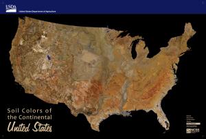
Soil Colors of the United States
Maps that show soil color at various depths for individual States and the Continental United States.
Download images or animated gif files of the soil color maps.
Download georeferenced tif files at 30 m resolution for use with GIS software.

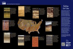
The color of soil is one of the few things in nature that is arguably of equal interest to both natural resource scientists and children at play. Successful soil scientists and surveyors appreciate the tremendous quantity of information that is typically related to soil color variation in depth and space. While not always entirely quantitative, soil color supports a practical, qualitative scaffolding for our understanding of a landscape’s recent and long-term history, clues about dominant mineralogy, a striking picture of where organic matter has accumulated, and many other factors that affect our use and understanding of the soil resource. Given the right context, soil color and its interpretation can be effectively used as a narrative for educating people about “what types of soils are where, and why?”. To communicate this part-art and part-science topic, Soil and Plant Science Division staff have recently created maps and images displaying soil colors in both the vertical and horizontal dimensions. Enjoy this unique opportunity to see how soils and geologic features are inextricably linked and vary across the landscape.
Ordering a Poster
The poster “Soil Colors of the Continental United States” is available from:
NRCS Distribution Center
Enter keywords: soil colors
Phone: 888-526-3227
E-mail: NRCSDistributionCenter@ia.usda.gov
You can also download the poster:
Contact Soils
Please contact us if you see something that needs to be updated, if you have any questions, or if you need accessibility assistance.