
Gridded National Soil Survey Geographic Database (gNATSGO)
The gridded National Soil Survey Geographic Database (gNATSGO) is a USDA NRCS Soil and Plant Science Division (SPSD) composite database that provides complete coverage of the best available soils information for all areas of the United States and its Territories.
Quick Links
Download Database
Description
Metadata
Technical Information
Data Citations for gNATSGO
Download Database
Download the gNATSGO database..
Description
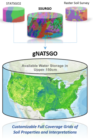
The gridded National Soil Survey Geographic Database (gNATSGO) is a USDA NRCS SPSD composite database that provides complete coverage soils information for all areas of the United States and its Territories. It was created by combining data from the Soil Survey Geographic (SSURGO) database, State Soil Geographic (STATSGO2) database, and Raster Soil Survey (RSS) databases into a single, seamless GeoPackage database.
The gNATSGO database uses the GeoPackage version of the SQLite SSURGO Template schema. Tabular soils data containing soil properties, soil interpretations, soil classifications, and vegetative community information are stored within 70 related tables located inside the GeoPackage database. The spatial soils data are delivered as raster files but exist outside of the database as GeoTIFFs. The database and rasters are designed to be accessed by any application or tool that can read an SQLite file and GeoTIFF, including GIS software. The complex tabular data are best accessed with the new SSURGO Portal Soil Data Viewer (SDV) soil data aggregation tool, which cuts through all the related tabular tables and produces simplified tables of data that can be joined to the rasters in GIS.
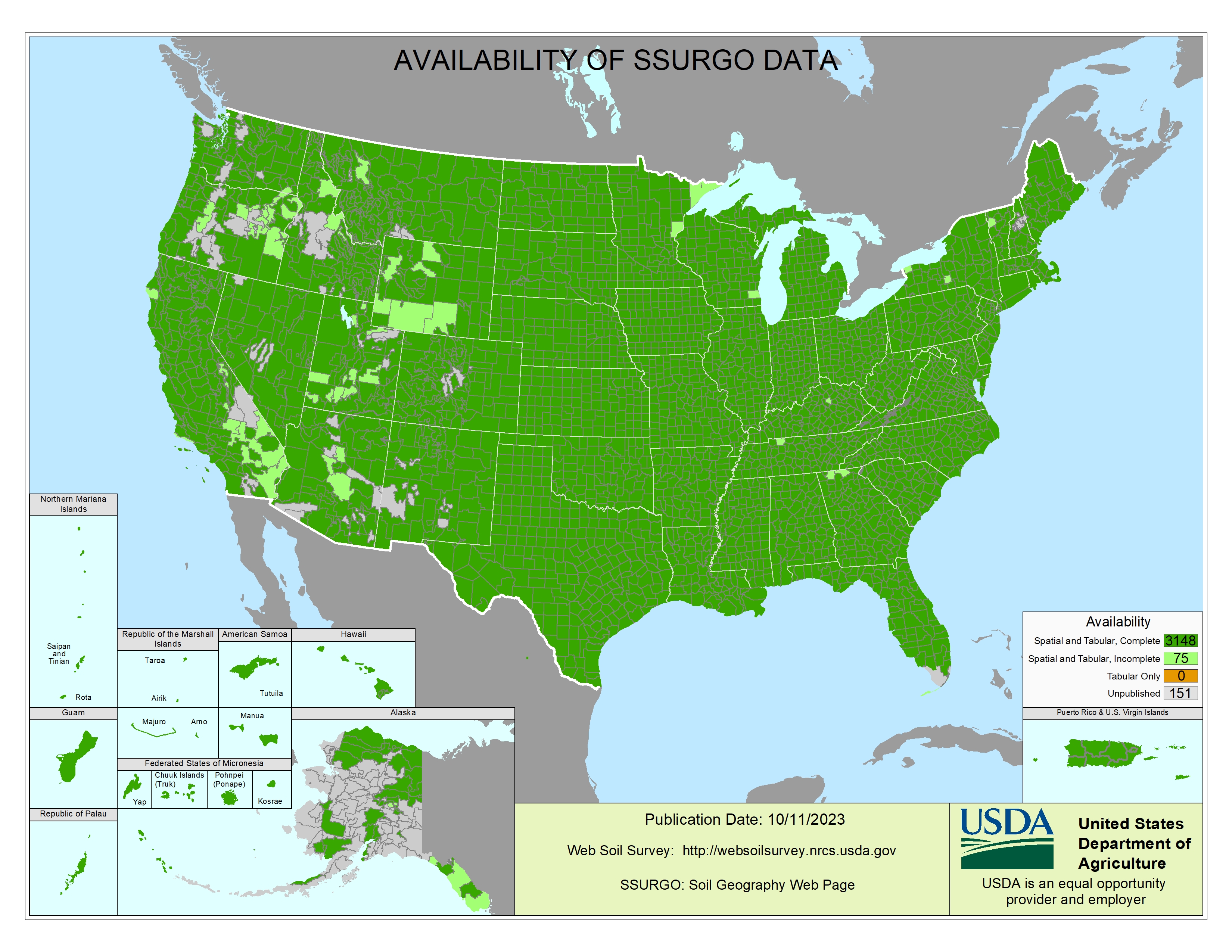
SSURGO is the SPSD flagship soils database that has over 100 years of field-validated detailed soil mapping data. SSURGO contains soils information for more than 90 percent of the United States and its Territories, but unmapped land remains. The Availability of SSURGO Data map shows the current completion status of SSURGO mapping. STATSGO2 is a general soil map that has soils data for all the United States and its Territories, but the data is not as detailed as the SSURGO data. The RSSs are the next generation soil survey databases developed using advanced digital soil mapping methods.
The gNATSGO database is composed primarily of SSURGO data, but STATSGO2 data was used to fill in the gaps. The RSSs are newer product with relatively limited spatial extent. These RSSs were merged into the gNATSGO after combining the SSURGO and STATSGO2 data. The extent of RSS is expected to increase in the coming years.
Notes
- The USDA NRCS SPSD refreshes all published soil databases annually, and gNATSGO is included in the refresh cycle. This will provide a new up-to-date version of the database each year.
- There is no vectorized version of the soil map unit included in gNATSGO.
- The raster can be joined to other tables on the MUKEY field.
- The map unit grid is 10 meters for State databases and 30 meters for large databases covering all areas of the United States and its Territories.
- An included raster file shows the source of the data.
Metadata
Metadata is stored in the database and can found in the tables that start with “md.”
gNATSGO has a schema that is very similar to that of SSURGO and STATSGO2. The SSURGO/STATSGO2 Structural Metadata web page contains information about the gNATSGO database tables and columns.
Technical Information
To obtain technical information about the use of soils data, please contact your NRCS State Soil Scientist or the Soils Hotline Staff at 402-437-5379.
Data Citations for gNATSGO
Soil Survey Staff (2026). Gridded national soil survey geographic (gNATSGO) database. USDA Natural Resources Conservation Service. https://nrcs.app.box.com/v/soils
Citation Examples
State Tile
Soil Survey Staff (2026). Gridded national soil survey geographic (gNATSGO) database for Texas. USDA Natural Resources Conservation Service. https://nrcs.app.box.com/v/soils
Conterminous U.S. Tile
Soil Survey Staff (2026). Gridded national soil survey geographic (gNATSGO) database for the conterminous United States. USDA Natural Resources Conservation Service. https://nrcs.app.box.com/v/soils
Contact Soils
Please contact us if you see something that needs to be updated, if you have any questions, or if you need accessibility assistance.