
Gridded Soil Survey Geographic (gSSURGO) Database
Gridded SSURGO (gSSURGO) is similar to the standard USDA-NRCS Soil Survey Geographic (SSURGO) Database product but in the format of an Environmental Systems Research Institute, Inc. (ESRI®) file geodatabase.
Download gSSURGO Databases
CONUS - soils | Powered by Box
State Databases - soils | Powered by Box
The gSSURGO CONUS database is too large for download as a single zip file. It has been split into smaller files for ease of download. All files must be downloaded to access gSSURGO CONUS. A pdf of instructions is available for download with the gSSURGO for CONUS link above.
Introduction
Gridded SSURGO (gSSURGO) is similar to the standard USDA-NRCS Soil Survey Geographic (SSURGO) Database product but in the format of an Environmental Systems Research Institute, Inc. (ESRI®) file geodatabase. A file geodatabase has the capacity to store much more data and thus greater spatial extents than the traditional SSURGO product. This makes it possible to offer these data in statewide or even conterminous United States (CONUS) tiles. gSSURGO contains all of the original soil attribute tables in SSURGO. All spatial data are stored within the geodatabase instead of externally as separate shapefiles. Both SSURGO and gSSURGO are considered products of the National Cooperative Soil Survey (NCSS) partnership.
The gridded SSURGO (gSSURGO) dataset was created for use in national, regional, and statewide resource planning and analysis of soils data. The raster map layer data can be readily combined with other national, regional, and local raster layers, including the National Land Cover Database (NLCD), the National Agricultural Statistics Service (NASS) Crop Data Layer (CDL), and the National Elevation Dataset (NED).
The gSSURGO Database is derived from the official Soil Survey Geographic (SSURGO) Database. SSURGO generally has the most detailed level of soil geographic data developed by the National Cooperative Soil Survey (NCSS) in accordance with NCSS mapping standards. The tabular data represent the soil attributes and are derived from properties and characteristics stored in the National Soil Information System (NASIS). The gSSURGO data were prepared by merging the traditional vector-based SSURGO digital map data and tabular data into statewide extents, adding a statewide gridded map layer derived from the vector layer, and adding a new value-added look up table (Valu1) containing “ready to map” attributes. The gridded map layer is a file geodatabase raster in an ArcGIS file geodatabase. The raster and vector map data have a statewide extent. The raster map data have a 10-meter cell size that approximates the vector polygons in an Albers Equal Area projection. Each cell (and polygon) is linked to a map unit identifier called the map unit key. A unique map unit key is used to link the raster cells and polygons to attribute tables. Due to file size, the raster layer for the conterminous United States is only available in a 30-meter resolution.
SSURGO/gSSURGO ArcTools
Download the Soil Data Development Toolbox (ZIP file)
The Soil Data Development Tools for ArcGIS™ includes the same toolset used by USDA-NRCS to create and publish the gSSURGO databases each year. Other tools for creating soil maps and reports are also included. See the Development User Guide and the gSSURGO Mapping Toolset documents for more information.
Please send comments and questions to soilshotline@usda.gov.
Most customers will only need to use the Create Soil Map Tool, which is in the gSSURGO Mapping Toolset.
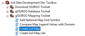
The Create Soil Map tool replicates the functionality of Web Soil Survey and Soil Data Viewer. It allows users to create on demand thematic maps of soil properties or interpretations with controls for aggregation method and depth.
The Valu1 (Value Added Look Up) Table
Included with the gSSURGO database, but not a part of the standard SSURGO dataset is a table called Valu1. This table contains 57 pre-summarized or “ready to map” attributes derived from the official SSURGO database. These attribute data are pre-summarized to the map unit level using best-practice generalization methods intended to meet the needs of most users. The generalization methods include map unit component weighted averages and percent of the map unit meeting a given criteria. These themes were prepared to better meet the mapping needs of users of soil survey information and can be used with both SSURGO and gridded SSURGO (gSSURGO) datasets. Below is a partial list of the data found in the valu1 table.
- Soil organic carbon - weighted average (g C/m2)
- Available water storage - weighted average (mm)
- National Commodity Crop Productivity Index (NCCPI) Version 3 - weighted average index for major components (Dobos, Sinclair, and Robotham, 2012)
- Root-zone depth of commodity crops - weighted average (cm) major components (Dobos et al., 2012)
- Available water storage within the root-zone depth - weighted average (mm) major components
- Drought-vulnerable soil landscapes (The map unit is identified as either drought vulnerable or not drought vulnerable. Drought-vulnerable soil landscape map units have 152 millimeters (6 inches) or less root zone available water storage for major components.)
- Potential wetland soil landscapes (PWSL Version 1) - percentage of the map unit that meets the criteria for a potential wetland soil landscape (see table metadata for detailed criteria)
Metadata
SSURGO/STATSGO2 Structural Metadata and Documentation
The metadata page for SSURGO/STATSGO2 contains information about the database structure and contents that are also relevant to gSSURGO.
Recommended Data Citations
The Citation for gSSURGO
State Tile
Soil Survey Staff. Gridded Soil Survey Geographic (gSSURGO) Database for State name. United States Department of Agriculture, Natural Resources Conservation Service. Available online at https://gdg.sc.egov.usda.gov/. Month, day, year (FYyear official release).
Conterminous U.S. Tile
Soil Survey Staff. Gridded Soil Survey Geographic (gSSURGO) Database for the Conterminous United States. United States Department of Agriculture, Natural Resources Conservation Service. Available online at https://gdg.sc.egov.usda.gov/. Month, day, year (YYYYMM official release).
National Collection of Tiles
Soil Survey Staff. Gridded Soil Survey Geographic (gSSURGO) Database for the United States of America and the Territories, Commonwealths, and Island Nations served by the USDA-NRCS. United States Department of Agriculture, Natural Resources Conservation Service. Available online at https://gdg.sc.egov.usda.gov/. Month, day, year (YYYYMM official release).
The Citation for the National Value Added Look Up (valu) Table Database
Soil Survey Staff. National Value Added Look Up (valu) Table Database for the Gridded Soil Survey Geographic (gSSURGO) Database for the United States of America and the Territories, Commonwealths, and Island Nations served by the USDA-NRCS. United States Department of Agriculture, Natural Resources Conservation Service. Available online at https://gdg.sc.egov.usda.gov/. Month, day, year (YYYYMM official release).
Citation Examples
The following examples are for the July 2020 gSSURGO dataset for the State of West Virginia. Such citations should appear in the reference section of your document.
State Tile
Soil Survey Staff. The Gridded Soil Survey Geographic (gSSURGO) Database for West Virginia. United States Department of Agriculture, Natural Resources Conservation Service. Available online at https://gdg.sc.egov.usda.gov/. November 16, 2020 (202007 official release).
Conterminous U.S. Tile
Soil Survey Staff. Gridded Soil Survey Geographic (gSSURGO) Database for the Conterminous United States. United States Department of Agriculture, Natural Resources Conservation Service. Available online at https://gdg.sc.egov.usda.gov/. November 16, 2020 (202007 official release).
National Collection of Tiles
Soil Survey Staff. Gridded Soil Survey Geographic (gSSURGO) Database for the United States of America and the Territories, Commonwealths, and Island Nations served by the USDA-NRCS. United States Department of Agriculture, Natural Resources Conservation Service. Available online at https://gdg.sc.egov.usda.gov/. November 16, 2020 (202007 official release).
See Citing Our Databases for recommended citations for other data provided by the USDA Natural Resources Conservation Service and the National Cooperative Soil Survey.
Technical Information
To obtain technical information about the use of soil data, please contact the NRCS State Soil Scientist in your state, or email the Soils Hotline Staff.
Sample gSSURGO Map Themes
(example maps coming soon)
Contact Soils
Please contact us if you see something that needs to be updated, if you have any questions, or if you need accessibility assistance.