
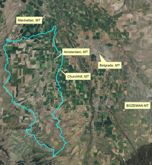
With the help of partners at the local, state and national level, NRCS identified Camp and Godfrey Creeks as a priority watershed where on-farm conservation investments through the National Water Quality Initiative will deliver the greatest water quality benefits.
LEARN MORE ABOUT THE NATIONAL WATER QUALITY INITIATIVE
The goals of Camp and Godfrey Creeks National Water Quality Initiative (NWQI): Reduce sediment and agricultural related nutrient loads and E.coli and improve riparian function.
Project Description
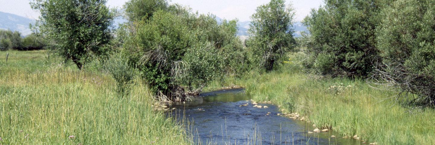
Camp Creek flows from the headwaters of the Madison Plateau (Camp Creek Hills), through Amsterdam, and outlets into the Gallatin River northeast of Manhattan in Gallatin County, Montana. Godfrey Creek also flows from the headwaters of the Madison Plateau, through Churchill, and outlets into Moreland Ditch. Godfrey Creek has been altered to no longer have a natural flow path beyond Moreland Ditch. The primary land use for both creeks is agriculture, comprised mainly of rangeland, pasture, and irrigated and dryland cropland. These two water bodies are also heavily impacted by livestock operations, irrigation withdrawals and returns, residential development, and channel modification/straightening. Thus, with livestock, cropping, and residential land use activities in close proximity to both water bodies, the potential for excess nutrients, fine sediment, flow alterations, and E. coli entering the stream is high.
Camp Creek was listed on the 2012 303(d) list as being impaired due to total nitrogen (TN) nutrient impairment, sediment, flow alterations, and E. coli, by the Montana Department of Environmental Quality (DEQ). Water samples collected by Montana DEQ between 2001 and 2009 also showed elevated levels of total phosphorus (TP). Godfrey Creek was listed on the 2012 303(d) list as being impaired due to TN, TP, flow alterations, excess algal growth, sedimentation, and E. coli. A Lower Gallatin Planning Area Total Maximum Daily Loads (TMDLs) and Framework Water Quality Improvement Plan was developed in 2013 by Montana DEQ. The document provided specific guidance on TMDL allocations and required load reductions for both Camp and Godfrey Creek. Consequently, the streams were removed from the 303(d) and moved to the “Impaired Waters” category within the MT DEQ 2014 Water Quality Integrated Report. The listed impairments for Camp Creek related to agriculture, livestock production, stream channelization, and development include: alteration in stream-side or littoral vegetative covers, E. coli, low flow alterations, TN, TP, and sedimentation/siltation. Godfrey Creek’s listed impairments include: alteration in stream-side or littoral vegetative covers, E. coli, TN, TP, and sedimentation/siltation.
Who Can Participate?
Farmers and ranchers located in the Camp and Godfrey Creek Watersheds in Gallatin County are eligible to apply for assistance through the National Water Quality Initiative.
Applicable Conservation Practices
Through the Environmental Quality Incentives Program (EQIP) eligible landowners receive assistance for installing conservation systems that meet the goals of the NWQI. Practices are not limited; all conservation practices on all land uses are available for consideration for technical and financial assistance.
Detailed descriptions of these conservation practices can be found in the Field Office Technical Guide, Section 4 - Practice Standards and Supporting Documents.
When to Apply
Program applications are accepted on a continual basis. However, NRCS establishes application ranking dates for evaluation, ranking and approval of eligible applications. Applications received after the ranking date will be automatically deferred to the next funding period. See Montana Programs and Application Dates.
Applications must meet the intent of this initiative. For more details about this initiative, contact your local field office.
Local Ranking Questions
NRCS uses these questions to evaluate eligible applications for this project and to prioritize applications for potential funding.
- Is the contracted area located within ½ mile of either waterbody?
- Is the contracted area located from ½ mile to within one mile of either waterbody?
- Does the proposed project include practices that enhance water quality through the reduction of sedimentation, nutrient load, or E. Coli?
- Will the practices in the application result in the relocation or closure of an AFO/CAFO facility to address surface water resource concerns evaluated by reducing the MontFARM index value to less than 19?
Additional Montana Information
The National Water Quality Initiative in Montana is funded through the Environmental Quality Incentives Program (EQIP).
Ready to get started?
Contact your local service center to start your application.
How to Get Assistance
Do you farm or ranch and want to make improvements to the land that you own or lease?
Natural Resources Conservation Service offers technical and financial assistance to help farmers, ranchers and forest landowners.
To get started with NRCS, we recommend you stop by your local NRCS field office. We’ll discuss your vision for your land.
NRCS provides landowners with free technical assistance, or advice, for their land. Common technical assistance includes: resource assessment, practice design and resource monitoring. Your conservation planner will help you determine if financial assistance is right for you.
We’ll walk you through the application process. To get started on applying for financial assistance, we’ll work with you:
- To fill out an AD 1026, which ensures a conservation plan is in place before lands with highly erodible soils are farmed. It also ensures that identified wetland areas are protected.
- To meet other eligibility certifications.
Once complete, we’ll work with you on the application, or CPA 1200.
Applications for most programs are accepted on a continuous basis, but they’re considered for funding in different ranking periods. Be sure to ask your local NRCS district conservationist about the deadline for the ranking period to ensure you turn in your application in time.
As part of the application process, we’ll check to see if you are eligible. To do this, you’ll need to bring:
- An official tax ID (Social Security number or an employer ID)
- A property deed or lease agreement to show you have control of the property; and
- A farm number.
If you don’t have a farm number, you can get one from USDA’s Farm Service Agency. Typically, the local FSA office is located in the same building as the local NRCS office. You only need a farm number if you’re interested in financial assistance.
NRCS will take a look at the applications and rank them according to local resource concerns, the amount of conservation benefits the work will provide and the needs of applicants. View Application Ranking Dates by State.
If you’re selected, you can choose whether to sign the contract for the work to be done.
Once you sign the contract, you’ll be provided standards and specifications for completing the practice or practices, and then you will have a specified amount of time to implement. Once the work is implemented and inspected, you’ll be paid the rate of compensation for the work if it meets NRCS standards and specifications.