
NRCS uses Landscape Conservation Initiatives to accelerate the benefits of voluntary conservation programs, such as cleaner water and air, healthier soil and enhanced wildlife habitat.
NRCS conservation programs help agricultural producers improve the environment while maintaining a vibrant agricultural sector.
These initiatives enhance the locally driven process to better address nationally and regionally important conservation goals that transcend localities. They build on locally led efforts and partnerships, and they’re based on science. Through the initiatives, NRCS and its partners coordinate the delivery of assistance where it can have the most impact. Where applicable, NRCS works with regulators to help producers get predictability for their use of voluntary conservation systems or practices, giving them peace of mind they can sustain agricultural production in the future.

These landscape-level efforts have seen success across the country. From the removal of streams from federal impaired streams list to the determination not to list the greater sage-grouse and New England cottontail, NRCS’ work with producers benefits wildlife, natural resources and agricultural operations across the country.
Since establishing the initiatives under the 2008 Farm Bill, NRCS has used successes and lessons learned to enhance the delivery of the initiatives. With tools like the Regional Conservation Partnership Program, the 2018 Farm Bill further emphasizes the focus on building effective partnerships and obtaining meaningful results for key natural resource concerns.
For more information:
Martin Lowenfish, Areawide Planning Branch Chief (202) 690-4979

Frameworks for Conservation Action
These frameworks capture the science documenting the threats to biomes and their wildlife and the conservation actions that NRCS can support to address these threats and benefit producers.
The Illinois Landscape Conservation Initiatives include:
- Joint Chiefs' Landscape Restoration Partnership (JCLRP) - Cross Boundary Upland Oak Restoration
- Mississippi River Basin Healthy Watersheds Initiative (MRBI)
- National Water Quality Initiative (NWQI)
- Working Lands for Wildlife (WLFW) - Northern Bobwhite
- Working Lands for Wildlife (WLFW) - Monarch Butterfly
Joint Chiefs' Landscape Restoration Partnership (JCLRP)
Description: Under the Joint Chiefs’ Landscape Restoration Partnership (JCLRP), NRCS and the U.S. Forest Service are working together to target conservation and restoration to measurably improve the health and resiliency of forest and grassland ecosystems where public and private lands meet to provide for long-term natural resources and production benefits. A project proposal was submitted and selected for the Cross-Boundary Upland Oak Restoration project in southern Illinois. The project is three years long and begins in fiscal year (FY) 2023 and will extend through FY 2025.
Application Deadline: May 30, 2025
3 Project Areas in the Following Counties:
- Alexander
- Gallatin
- Hardin
- Jackson
- Johnson
- Massac
- Saline
- Pope
- Union
Mississippi River Basin Healthy Watersheds Initiative (MRBI)
Description: Through the Mississippi River Basin Healthy Watersheds Initiative, the Natural Resources Conservation Service and partners work with producers and landowners to implement voluntary conservation practices that improve water quality, restore wetlands, enhance wildlife habitat, and sustain agricultural profitability in the Mississippi River Basin.
NRCS has identified the Mississippi River Basin as a top priority due to water quality concerns, primarily related to the effects of nutrient loading on the health of local water bodies and, eventually, the Gulf of Mexico. The 13-state Initiative builds on the cooperative work of NRCS and its conservation partners in the basin and offers agricultural producers in priority watersheds the opportunity for voluntary technical and financial assistance. The participating States are Arkansas, Kentucky, Illinois, Indiana, Iowa, Louisiana, Minnesota, Mississippi, Missouri, Ohio, South Dakota, Tennessee, and Wisconsin.
Application Deadline: February 28, 2025
Applicable Watersheds:
- Clinton Lake - located in DeWitt, McLean, and Piatt Counties
- Upper Macoupin Creek - located in Macoupin County
- Vermilion Headwaters - located in Ford, Iroquois, Livingston, and McLean Counties
National Water Quality Initiative (NWQI)
Description: Through the National Water Quality Initiative, eligible producers will invest in voluntary conservation practices to help provide cleaner water for their neighbors and communities. Using funds from the Environmental Quality Incentives Program, NRCS will provide financial and technical assistance to producers for implementing conservation practices such as cover crops, grassed waterways, terraces, and water and sediment control basins in watersheds with impairments where federal investments can make a difference in improving water quality.
Application Deadline: May 30, 2025
Applicable Watersheds:
- Friends Creek - located in DeWitt, Macon, and Piatt Counties
- Money Creek - located in McLean County
- Panther Creek - located in Sangamon County
Working Lands for Wildlife (WLFW) – Northern Bobwhite
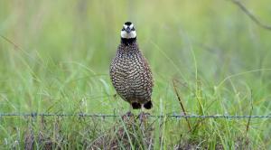
Description: The northern bobwhite (Colinus virginianus) is often referred to as an “edge” species, seeking habitat where crop fields intersect with woodlands, pastures and old fields. Historically, land use favored bobwhite, but changes in land use and how lands are managed have caused the bird’s numbers to dip by more than 80 percent over the last 60 years.
Bobwhites depend on early successional habitat grasslands, shrubby areas, and pine or oak savannahs found across the East. These habitats have the forbs, legumes and insects that bobwhite need for food and the heavy or brushy cover for nesting, brooding and safety. To help reverse bobwhite declines, NRCS is working with private landowners in 14 states to manage for high-quality early successional habitat.
Application Deadline: May 30, 2025
Applicable Counties: Adams, Alexander, Bond, Brown, Bureau, Calhoun, Cass, Christian, Clark, Clay, Clinton, Crawford, Cumberland, Edwards, Effingham, Fayette, Franklin, Fulton, Gallatin, Greene, Hamilton, Hancock, Hardin, Henderson, Henry, Jackson, Jasper, Jefferson, Jersey, Johnson, Knox, Lawrence, Logan, McDonough, Macoupin, Madison, Marion, Marshall, Mason, Massac, Menard, Mercer, Monroe, Montgomery, Morgan, Peoria, Perry, Pike, Pope, Pulaski, Putnam, Randolph, Richland, Rock Island, St. Clair, Saline, Sangamon, Schuyler, Scott, Shelby, Stark, Tazewell, Union, Wabash, Warren, Washington, Wayne, White, Williamson, and Woodford.
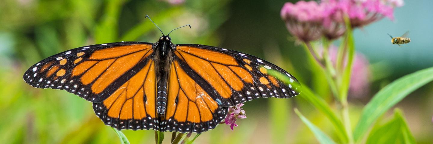
Working Lands for Wildlife (WLFW) – Monarch Butterfly
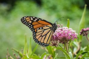
Description: The monarch butterfly is one of the most iconic butterflies in North America and is known in part for its annual multi-generational migration from overwintering sites in central Mexico and coastal California to as far north as Canada. Multiple critical population stressors including the loss and degradation of habitat across the species' range have led to a significant decrease in the number of monarchs in the U.S. over the past few decades.
But monarch populations have decreased significantly over the past two decades, in part because of the decrease in native plants, including milkweed, on which their caterpillars feed. Agriculture and development have removed much of the native milkweed that once spanned the country.
NRCS is working with agricultural producers in the Midwest and southern Great Plains to combat the decline of monarch butterflies by planting milkweed and other nectar-rich plants on private lands. This region, which includes Illinois, Indiana, Iowa, Kansas, Minnesota, Missouri, Ohio, Oklahoma, Texas, and Wisconsin, is the core of the monarch’s migration route and breeding habitat.
Application Deadline: May 30, 2025
Applicable Counties: All Illinois counties
Additional Information
More Conservation News
Visit Farmers.gov to get the latest news and updates from the blog.
Watch the Videos
Browse the collection of videos showcasing the Landscape Conservation Initiatives, from improving water quality to helping restoring pollinators to your farm.
Ready to get started?
Contact your local service center to start your application.
How to Get Assistance
Do you farm or ranch and want to make improvements to the land that you own or lease?
Natural Resources Conservation Service offers technical and financial assistance to help farmers, ranchers and forest landowners.
To get started with NRCS, we recommend you stop by your local NRCS field office. We’ll discuss your vision for your land.
NRCS provides landowners with free technical assistance, or advice, for their land. Common technical assistance includes: resource assessment, practice design and resource monitoring. Your conservation planner will help you determine if financial assistance is right for you.
We’ll walk you through the application process. To get started on applying for financial assistance, we’ll work with you:
- To fill out an AD 1026, which ensures a conservation plan is in place before lands with highly erodible soils are farmed. It also ensures that identified wetland areas are protected.
- To meet other eligibility certifications.
Once complete, we’ll work with you on the application, or CPA 1200.
Applications for most programs are accepted on a continuous basis, but they’re considered for funding in different ranking periods. Be sure to ask your local NRCS district conservationist about the deadline for the ranking period to ensure you turn in your application in time.
As part of the application process, we’ll check to see if you are eligible. To do this, you’ll need to bring:
- An official tax ID (Social Security number or an employer ID)
- A property deed or lease agreement to show you have control of the property; and
- A farm number.
If you don’t have a farm number, you can get one from USDA’s Farm Service Agency. Typically, the local FSA office is located in the same building as the local NRCS office. You only need a farm number if you’re interested in financial assistance.
NRCS will take a look at the applications and rank them according to local resource concerns, the amount of conservation benefits the work will provide and the needs of applicants. View Application Ranking Dates by State.
If you’re selected, you can choose whether to sign the contract for the work to be done.
Once you sign the contract, you’ll be provided standards and specifications for completing the practice or practices, and then you will have a specified amount of time to implement. Once the work is implemented and inspected, you’ll be paid the rate of compensation for the work if it meets NRCS standards and specifications.