
Helpful Heaps of Soil Survey Data to Assist in Forest Management
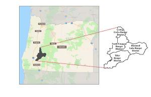
Spanning over one million acres, NRCS soil scientists’ survey work in Oregon’s Umpqua National Forest will culminate in heaps of data and information to assist with science-based land management. Modern mapping technology provides vital data for farmers, ranchers, federal agencies, and others.
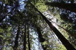
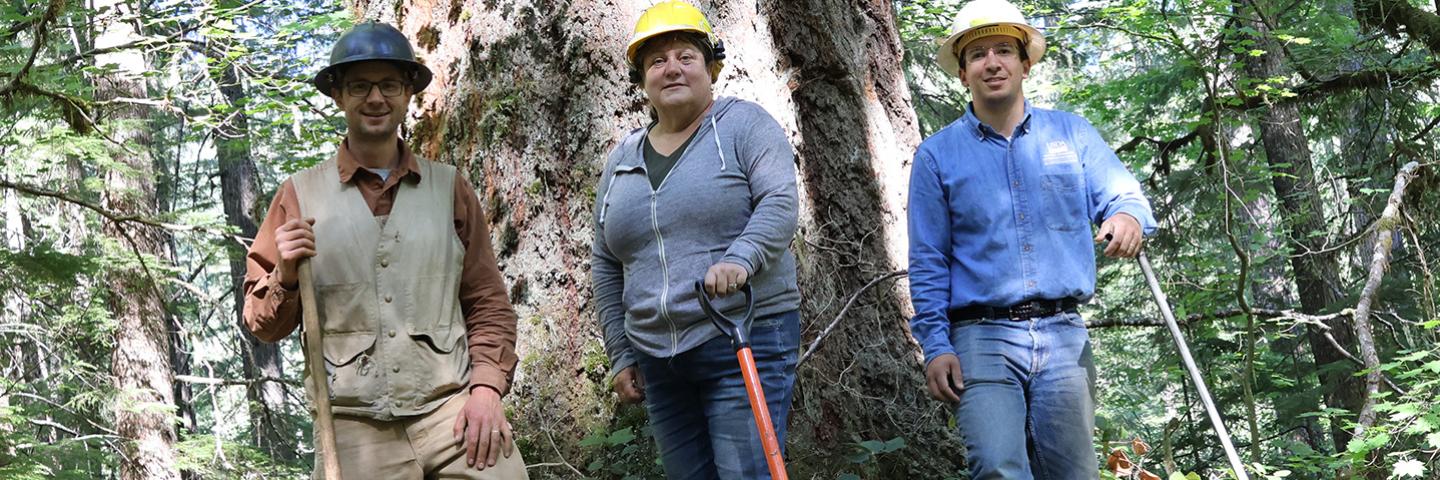
The sun peeks through a canopy of old growth trees towering over undisturbed acres of ferns and other plants shimmering in the light. Soil scientists from the USDA’s Natural Resources Conservation Service (NRCS) join an archaeologist from the Umpqua National Forest to look at, listen to, and learn from the soil beneath their feet and the sea of green leaves surrounding them. Time seems to stand still in the quiet forest, but a modern collection of data is afoot.
The last time the NRCS produced any kind of soil map on the Forest was in the 1970s, long before the advent of LiDAR, GPS, and computers. With today’s technology, the soil scientists’ work will culminate in modern mapping information placed in the Soil Survey Geographic Database, or SSURGO, a source of soils data collected by NRCS and other partners over the last century. For advanced data users, the SSURGO Portal is where the Forest Service and public will be able to access the information collected in the Forest, or it can also be accessed in Web Soil Survey. The soil survey will provide heaps of data and information to assist the Forest Service in making important science-based land management decisions.
Soil classifications and interpretations weren’t as comprehensive as they are today either. The soils on the Forest were classified before the adoption of the andic soil properties and the Andisol soil order was recognized in Soil Taxonomy. These soils are formed out of volcanic ash, and it’s evident that the snow-capped Cascade volcanoes found on this Forest once played a major role in redefining the landscape after cataclysmic eruptions. This led to the eventual formation of the ashy soils found throughout the Forest.
The implications of ashy soils are significant. Understanding a soil's properties, such as bulk density and soil carbon accumulation, is vital for forest planning, especially when considering the suitability of managed forests for various uses like roads, trails, and other infrastructure projects. In addition to soil properties and interpretations, one of the biggest uses of soil survey data is for ecological site interpretations. Part of a soil survey includes documenting ecological site descriptions—a site’s unique characteristics, including geology, soil, water features, vegetation and other factors. Plant species occurrence, plant community compositions, annual biomass production, and wildlife-vegetation interactions, as well as ecological dynamics like disturbance regimes such as grazing, fire, drought, management actions and all resulting interactions, factor into the development of ecological sites.
“This is some of the last remaining pieces of America that don’t have soil survey coverage, so it’s an honor to work on this project, and it’s really fun. . . it’s kind of like putting a puzzle together,” said Anthony Collora, major land resource area soil survey office leader in Salem, OR.
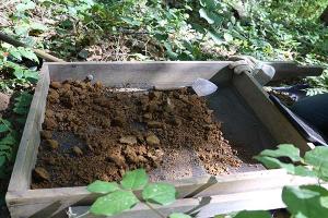
Soil surveys on the Forest require archaeological clearances as part of the National Historic Preservation Act, as well as Tribal consultation with area Tribes. Armed with a portable sifting screen, the Forest Service’s Rene Burke, seasonal archaeologist, joined the team to scope out the area to ensure there were no cultural resources.
“We have to identify, evaluate, and record anything that’s found that’s historic or prehistoric on the Forest. This is how we look for artifacts when the NRCS folks are doing soil tests,” said Burke, while moving the mesh screen bin filled with soil back and forth, sifting it, and looking through it with a shovel. “We can find evidence of past logging activity, mining, fur trapping. That's part of the history of western Oregon.”
The project area covers 1,037,698 acres of mostly Forest Service land, with some acres of non-federal land, census water, Bureau of Land Management land, Native American land, and National Park Service land.
“Since we have such a short time span to complete this massive project, we have to be very precise about where we dig our sites. When we go to a site, we collect pedon observations, or soil samples, and site observations, including the vegetation. Here in the West, the vegetation really gives you a good clue of what the soils are doing, so we like to choose points that have pretty intact native vegetation,” said Collora. “In an old growth stand, there’s less potential for disturbance, so we will see the natural soil body without it being disturbed or tilled or compacted by equipment.”
The survey helps support the Forest Service’s mission to sustain the health and productivity of the land—and soil is foundational to that.
“The more information that we can integrate into our planning will really benefit us. We also have soil standards and guidelines in our forest plan specific to the Umpqua that speak to the suitability of soils and erosion control. All these factors we weigh in when we have different management projects,” said Sarah Brame, soil scientist for the Umpqua National Forest. “The information that the NRCS soil team is going to be gathering, such as soil texture and structure, soil depth, and water holding capacity, feeds into this information of the capabilities of these soils. It will help us identify areas that are problematic and be able to identify opportunities for soils as well. The data also will help us with plant associations: to be able to tie in a soil type with the plant association for fuel reduction practices, meadow restorations, and what we do in the post-fire environment. We do a lot of erosion and hydro modeling, so the more precise soil data that we can feed into those models is going to give us a better result.”
Project fieldwork will conclude in 2025, with total project completion projected for March 2026. Soil survey information will then be available in Web Soil Survey in October 2026.
In addition to helping the Forest Service, soil surveys can help farmers and ranchers, homebuyers or realtors, land use planners, urban planners, coastal and estuarine land managers, builders and construction engineers, ecologists, and conservation planners. How can soil surveys help you? Visit Web Soil Survey to find data and information in your area.