

Coastal Zone Soil Survey
Definition, why it's needed, history, and additional information.
What Is It?
A Coastal Zone Soil Survey is a SSURGO (Order 2 soil survey map and data) product that focuses the soil survey maps and data in the coastal zone which includes the dunes, marshes, beaches, anthropogenic coastal areas and the shallow-subtidal subaqueous soils (submerged lands) where submerged aquatic vegetation (SAV) is either growing or has the potential to grow. Once completed, a coastal zone soil survey provides detailed (1:12,000 scale) spatial soil maps (points, lines, and polygons), a rich database of soil chemical and physical properties, site data, and interpretations for coastal applications (beach replenishment, aquaculture, coastal blue carbon, restoration, etc.).
Why Is It Needed? What Is It Used For?
Within the next decade, nearly three-fourths of the U.S. population is expected to live within 100 km of the coast (Beach, 2002). This high population density, together with its associated commerce, pollution, and development, will put significant stress on these coastal and near-shore ecosystems. In order to effectively study, manage, conserve, and sustain shallow-sub tidal ecosystems, a spatial inventory of the basic resources and habitats is essential. Coastal restoration projects such as sea-grass planting, oyster reef creation, beach replenishment, and salt marsh restoration are very expensive and the success or failure of the project depends on good scientific baseline data during the planning stages.
Terrestrial soil surveys provide detailed spatial data, chemical and physical properties of the soil, and interpretations (suitability and limitations) of the soil for over 50 different land-uses. Once completed, a coastal zone soil survey will also be useful for providing data and interpretations that will be useful for marine spatial planning, aquaculture, and coastal and near-shore restoration projects.
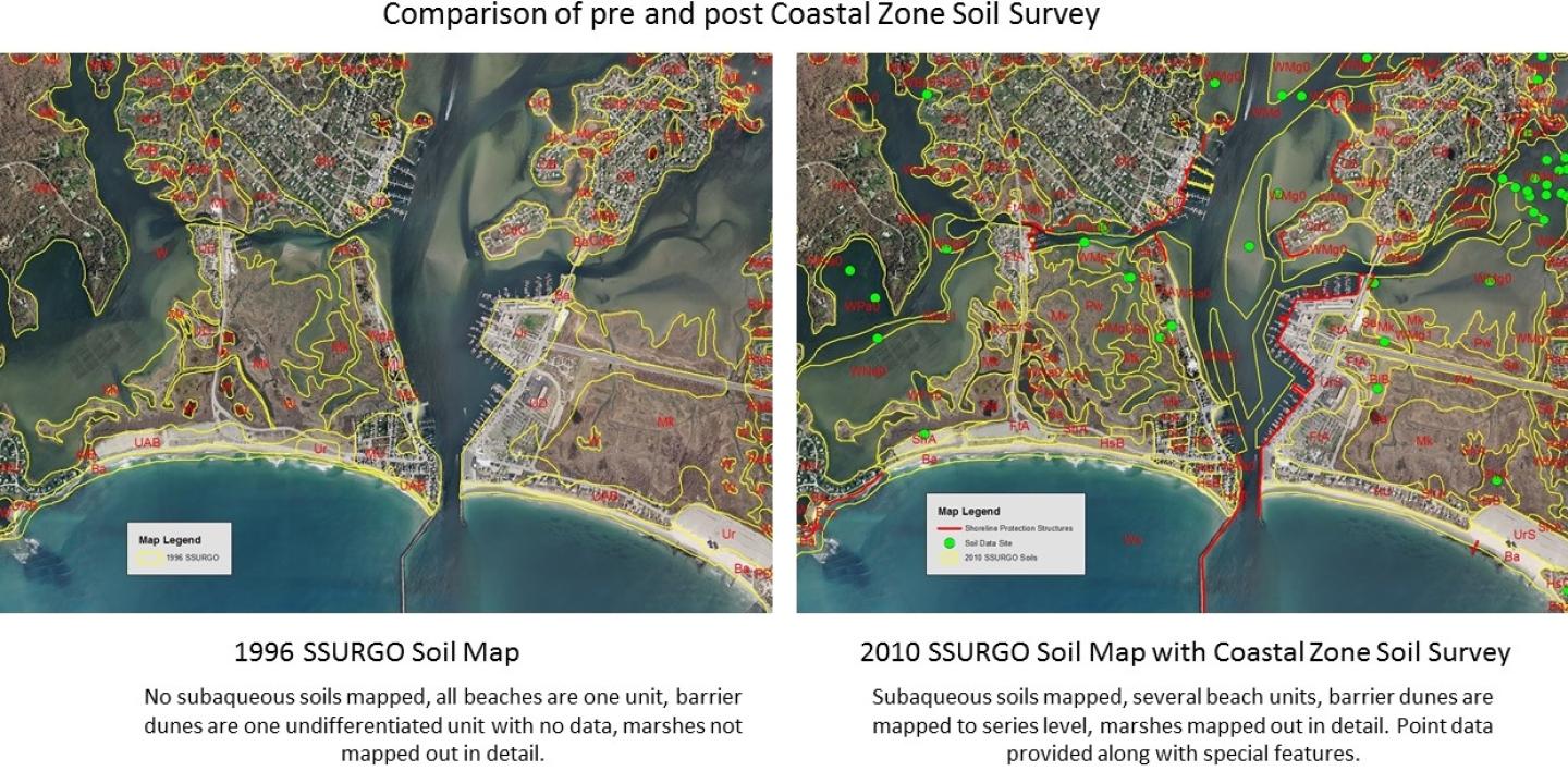
History
For the past 100 years, soil surveys have been produced as part of the National Cooperative Soil Survey and nearly 95% of the U.S. is mapped and available on the Web Soil Survey. For the most part, the coastal zone (dunes, marshes, beaches, and shallow sub-tidal lands) was not mapped to the map unit level (soil series level) as the terrestrial soils were and often provided little or no interpretive data. During the 1990s, an NRCS soil scientist named George Demas was conducting soil mapping in Worcester County, Maryland, along part of the Chesapeake Bay when he observed submerged aquatic vegetation and grabbed a soil core of the submerged meadow and observed soil horizons. George questioned why we were stopping our soil survey at the waters edge when these submerged areas met the criteria to be called soils. In 1993, Soil Survey Horizons (Volume 34, number 2) published a paper by George Demas titled “Submerged Soils: A New Frontier in Soil Survey” which outlined the need for the mapping and began the movement of the National Cooperative Soil Survey into the coastal zone. George worked with the University of Maryland to show that these subaqueous soils undergo pedogenic processes and should be considered as soil and mapped as part of the National Cooperative Soil Survey. As a result of George’s work, the definition of soil was changed in the 1999 edition of Soil Taxonomy to include subaqueous soils.
During the 2000s, soil survey work in the coastal zone began, mapping and research in Delaware, Maryland, and Rhode Island was conducted, University research began to study the coastal zone soils and a National Workshop on Subaqueous Soils was run in 2003 at Georgetown, Delaware. A graduate study at the University of Rhode Island mapping the subaqueous soils in Ninigret Pond caught the attention of the Rhode Island Natural Resources Conservation Service which had recently adopted a “Working Waters Strategic Plan” which focused Farm Bill money into coastal restoration. At this time a gap was identified in the RI soil survey data - no coastal or subaqueous soils were mapped. Under direction of the State Conservationist, RI NRCS began to focus the soil survey staff to complete a coastal zone soil survey and in 2010 the first example of a coastal zone soil survey was provided as a SSURGO product.
Documents
Additional Information
Coastal Zone Soil Survey Focus Team
Charges, activities, and contact information for the Coastal Zone Soil Survey Focus Team.
Learn MoreContact Soils
Please contact us if you see something that needs to be updated, if you have any questions, or if you need accessibility assistance.