
LAMOILLE SERIES
LOCATION MN+IL
Established Series
Rev. RAL-HRF-ROP
07/2004
The Lamoille series consists of well drained soils that formed in a thin mantle of loess and in underlying clayey residuum and loamy-skeletal colluvium. These soils are on hillslopes of dissected uplands and have gradients of 2 to 50 percent. They have very slow and slow permeability in the 2B horizon and moderate and moderately rapid permeability in the 3C horizon. Mean annual precipitation is about 31 inches, and mean annual temperature is about 49 degrees F.
TAXONOMIC CLASS: Fine, mixed, superactive, mesic Typic Hapludalfs
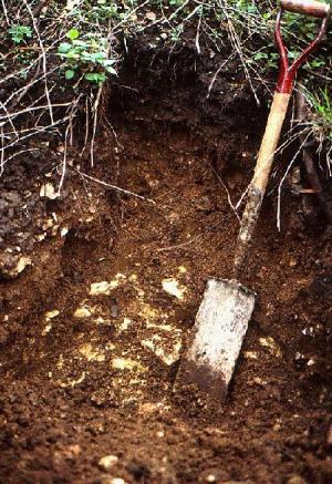
TYPICAL PEDON: Lamoille silt loam with a 35 percent convex north-facing hill slope in dissected uplands in a deciduous forest. (Colors are for moist soil unless otherwise noted.)
A--0 to 4 inches; very dark grayish brown (10YR 3/2) silt loam, dark grayish brown (10YR 4/2) dry; weak very fine subangular blocky structure; very friable; many fine roots, about 1 percent gravel, mostly dolomite; neutral; clear smooth boundary. (2 to 4 inches thick)
E--4 to 8 inches; dark grayish brown (10YR 4/2) silt loam, light brownish gray (10YR 6/2) dry; weak fine platy structure; very friable; many fine roots; about 1 percent gravel, mostly dolomite; neutral; clear smooth boundary. (3 to 6 inches thick)
BE--8 to 13 inches; brown (10YR 4/3) silt loam; weak very fine subangular blocky structure; friable; many fine roots; about 2 percent gravel of chert and dolomite; neutral; clear abrupt boundary. (0 to 7 inches thick)
2Bt1--13 to 27 inches; reddish brown (5YR 4/4) clay; strong fine subangular blocky structure; firm; common medium roots; continuous thick dark reddish brown (5YR 3/2) clay films on faces of peds; about 15 percent gravel of chert and cobbles of dolomite; moderately acid; clear wavy boundary. (10 to 30 inches thick)
3Bt2--27 to 37 inches; brown (7.5YR 4/4) very cobbly clay loam; weak fine subangular blocky structure; friable; continuous thin to thick dark reddish brown (5YR 3/2) clay films on faces of peds; about 50 percent gravel and cobbles of dolomite; few fine roots; neutral; clear smooth boundary. (8 to 25 inches thick)
3C--37 to 60 inches; yellowish brown (10YR 5/4) very cobbly loam; massive; friable; about 60 percent gravel and cobbles, mostly dolomite; slight effervescence; slightly alkaline.
TYPE LOCATION: Houston County, Minnesota; about 3 miles west of Caledonia; 2450 feet west and 35 feet south of the northeast corner of sec. 16, T. 102 N., R. 6 W.
RANGE IN CHARACTERISTICS: The thickness of solum and depth to free carbonates is 30 to 60 inches or more. The loess mantle is 5 to 15 inches in thickness. Dolomite bedrock occurs at depths of 40 to 100 inches or more. The average content of clay in the upper 20 inches of the argillic horizon ranges from 35 to 55 percent. The loess mantle has less than 5 percent rock fragments. The 2B horizon has 10 to 35 percent rock fragments and the 3B and 3C horizons have 35 to 70 percent rock fragments. The fragments in the loess and 2B horizon are both chert and dolomite. The fragments in the 3B and 3C horizons are cobbles and gravels of dolomite.
The A or Ap horizon has chroma of 1 or 2. The E horizon has value of 4 or 5 and chroma of 2 or 3. The A and E horizons are neutral or slightly acid.
The 2Bt horizon typically has hue of 5YR and less commonly 7.5YR. It has value and chroma of 4 through 6. It is silty clay loam, silty clay, clay or clay loam with 35 to 75 percent clay in the fine earth fraction. It is neutral to strongly acid. Some pedons have a thin Bt horizon formed in the upper mantle.
The 3Bt horizon typically has hue of 7.5YR and less commonly 10YR. It has value of 4 or 5. It is loam or clay loam in the fine earth fraction. It is moderately acid through neutral.
The 3C horizon has hue of 10YR or 2.5Y, value of 5 or 6, and chroma of 4 through 6. It is loam or sandy loam in the fine earth fraction. It is slightly alkaline or moderately alkaline.
COMPETING SERIES:
Beasley, Bland, Bledsoe, Bonnell, Brashear, Bratton, Briggsville, Brookside, Bucklick, Caneyville, Chrome, Derinda, Donahue, Eden, Edenton, Elba, Eldean, Estate, Faywood, Fredonia, Gunlock, Hagerstown, Heitt, Jessup, Kewaunee, Losantville, Lowell, Markland, Medary, Miamian, Milton, Newnata, Ozaukee, Shrouts, Solway (T), Upshur, Vandalia, Vincent, Winnegan, Woodsfield, and Wynn series. All of these soils have less than 35 percent rock fragments in the lower part of the series control section and above 40 inches.
GEOGRAPHIC SETTING: Lamoille soils have plane or convex slopes on back slopes and shoulders in dissected uplands. Slope gradients are 2 to 50 percent and lengths are 200 to 500 feet. Local relief ranges from 300 to 600 feet. The regolith consists of 5 to 15 inches of loess over 10 to 30 inches of clayey residuum overlying loamy-skeletal colluvium derived from dolomite. Mean annual temperature ranges from 42 to 50 degrees F, and mean annual precipitation ranges from 28 to 35 inches.
GEOGRAPHICALLY ASSOCIATED SOILS:
Blackhammer, Dorerton, Lacrescent, Nodine, Newhouse, Rollingstone, Seaton, Southridge, and Valton soils. Blackhammer, Nodine, Newhouse, Rollingstone, Southridge, and Valton soils are upslope with lesser gradient and contain less rock fragments. Dorerton soils are on positions similar to Lamoille soils, but they have loamy-skeletal argillic horizons. Lacrescent soils have a mollic epipedon have steeper slopes and typically are downslope. Seaton soils are upslope and formed in thick loess.
DRAINAGE AND PERMEABILITY: Well drained. Runoff is rapid or very rapid. Permeability is very slow and slow in the 2B horizon and moderate and moderately rapid in the 3C horizon.
USE AND VEGETATION: Most areas are in woodland or pasture. A few small areas are cultivated with legume hay and small grain being the principal crops. Native vegetation was deciduous forest.
DISTRIBUTION AND EXTENT: Southeastern Minnesota and possibly northeastern Iowa, northwestern Illinois, and southwestern Wisconsin. Moderately extensive.
MLRA SOIL SURVEY REGIONAL OFFICE (MO) RESPONSIBLE: St. Paul, Minnesota
SERIES ESTABLISHED: Houston County, Minnesota, 1981.
REMARKS: Diagnostic horizons and features recognized are: ochric epipedon - the zone from the surface to a depth of about 13 inches (A, E, and BE horizons); argillic horizon - the zone from about 13 to 37 inches (2Bt and 3Bt horizons); udic moisture regime.
ADDITIONAL DATA: Refer to Mn. Agr. Exp. Sta.
c.central file code No. 2382 for results of some laboratory analyses of the typical pedon.
National Cooperative Soil Survey
U.S.A.