
HOYLETON SERIES
LOCATION IL
Established Series
Rev. JBF-SEW-KAG
09/2021
The Hoyleton series consists of very deep, somewhat poorly drained soils on uplands. These soils formed in loess and the underlying silty or loamy deposits which overlie a strongly weathered Sangamon age paleosol in the Illinoian age till. Slope ranges from 0 to 7 percent. Mean annual precipitation is about 1016 mm (40 inches), and mean annual temperature is about 12 degrees C (53 degrees F).
TAXONOMIC CLASS: Fine, smectitic, mesic Aquollic Hapludalfs
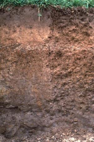
TYPICAL PEDON: Hoyleton silt loam, on a 2 percent slope in a cultivated field at an elevation of about 200 meters (655 feet) above mean sea level. (Colors are for moist soil unless otherwise stated.)
Ap--0 to 20 cm (0 to 8 inches); dark brown (10YR 3/3) and very dark grayish brown (10YR 3/2) silt loam, grayish brown (10YR 5/2) dry; weak fine granular structure; friable; many very fine roots; few fine distinct spherical weakly cemented black (10YR 2/1) iron-manganese concretions with sharp boundaries throughout; few fine distinct spherical extremely weakly cemented black (10YR 2/1) iron-manganese masses with sharp boundaries throughout; moderately acid; abrupt smooth boundary. [15 to 23 cm (6 to 9 inches) thick]
E--20 to 28 cm (8 to 11 inches); brown (10YR 5/3) silt loam; weak thin platy structure; friable; common very fine and few fine roots; common faint dark grayish brown (10YR 4/2) organic stains lining root channels and pores; few fine distinct spherical weakly cemented black (10YR 2/1) iron-manganese concretions with sharp boundaries throughout; few fine distinct spherical extremely weakly cemented black (10YR 2/1) manganese masses with sharp boundaries throughout; strongly acid; clear smooth boundary. [8 to 30 cm (3 to 12 inches) thick]
BEt--28 to 36 cm (11 to 14 inches); brown (10YR 5/3) silty clay loam; weak fine subangular blocky structure; friable; few very fine roots; few faint grayish brown (10YR 5/2) clay films and few faint very pale brown (10YR 7/3) silt coatings on faces of peds; few fine distinct yellowish brown (10YR 5/6) masses of oxidized iron in the matrix; few fine distinct spherical extremely weakly cemented black (10YR 2/1) iron-manganese concretions with sharp boundaries throughout; few fine distinct spherical extremely weakly cemented black (10YR 2/1) manganese masses with sharp boundaries throughout; strongly acid; clear smooth boundary. [0 to 13 cm (5 inches) thick]
Bt1--36 to 51 cm (14 to 20 inches); brown (10YR 5/3) silty clay loam; strong fine subangular blocky structure; firm; few very fine roots; many faint grayish brown (10YR 5/2) clay films and many prominent very pale brown (10YR 8/2) silt coatings on faces of peds; common medium prominent yellowish red (5YR 5/6 and 5YR 5/8) masses of oxidized iron in the matrix; common fine spherical iron-manganese concretions throughout; strongly acid; clear smooth boundary.
Bt2--51 to 84 cm (20 to 33 inches); brown (10YR 5/3) silty clay; moderate medium subangular blocky structure; firm; few fine and very fine roots; common distinct dark grayish brown (10YR 4/2) clay films on faces of peds; few distinct dark gray (10YR 4/1) clay films lining root channels and pores; common fine prominent yellowish red (5YR 5/8) masses of oxidized iron and common medium faint light brownish gray (2.5Y 6/2) iron depletions in the matrix; common fine distinct spherical weakly cemented black (10YR 2/1) iron-manganese concretions with sharp boundaries throughout; strongly acid; gradual smooth boundary. [Combined thickness of the Bt horizon is 38 to 112 cm (15 to 44 inches).]
2Bt3--84 to 99 cm (33 to 39 inches); pale brown (10YR 6/3) silty clay loam; weak coarse subangular blocky structure; firm; few fine and very fine roots; few faint grayish brown (10YR 5/2) clay films on faces of peds; few faint very dark grayish brown (10YR 3/2) organoargillans lining root channels and pores; many medium prominent yellowish brown (10YR 5/8) masses of oxidized iron and common medium faint light brownish gray (2.5Y 6/2) iron depletions in the matrix; common fine prominent spherical weakly cemented black (10YR 2/1) iron-manganese concretions with sharp boundaries throughout; about 10 percent fine sand; strongly acid; gradual smooth boundary. [15 to 76 cm (6 to 30 inches) thick]
2BCt--99 to 137 cm (39 to 54 inches); pale brown (10YR 6/3) silt loam; massive; friable; few very fine roots; few faint dark gray (10YR 4/1) clay films lining root channels and pores; few fine prominent yellowish brown (10YR 5/8) masses of oxidized iron and few fine faint yellowish brown (10YR 5/4) masses of oxidized iron and manganese in the matrix; common medium faint grayish brown (2.5Y 5/2) iron depletions in the matrix; common fine prominent spherical weakly cemented black (10YR 2/1) iron manganese concretions with sharp boundaries throughout; about 15 percent fine sand; slightly acid; gradual smooth boundary.
2Cg--137 to 203 cm (54 to 80 inches); brown (7.5YR 5/2) silt loam; massive; friable; many medium prominent strong brown (7.5YR 4/6) masses of oxidized iron and many medium distinct brown (7.5YR 4/4) masses of oxidized iron and manganese in the matrix; few fine prominent spherical weakly cemented black (10YR 2/1) iron-manganese concretions with sharp boundaries throughout; about 25 percent fine sand; slightly acid.
TYPE LOCATION: Shelby County, Illinois; 2,160 feet east and 295 feet south of the northwest corner of sec. 15, T. 9 N., R. 5 E.; USGS Shumway, Illinois topographic quadrangle; lat. 39 degrees 13 minutes 46.1 seconds N. and long. 88 degrees 37 minutes 48.4 seconds W.; UTM Zone 16, 359299 easting and 4343508 northing, NAD 83.
RANGE IN CHARACTERISTICS:
Depth to the base of the argillic horizon: greater than 91 cm (36 inches)
Depth to carbonates: greater than 152 cm (60 inches)
Thickness of the loess: 76 to 140 cm (30 to 55 inches); contains less than 7 percent fine sand or coarser
Particle-size control section: averages 35 to 45 percent clay
Ap or A horizon:
Hue: 10YR
Value: 2 or 3
Chroma: 1 to 3
Texture: silt loam
Reaction: very strongly acid to moderately acid, except in areas that have been limed that range to neutral
E horizon:
Hue: 10YR
Value: 4 to 6
Chroma: 3 or 4
Texture: silt loam
Reaction: very strongly acid to moderately acid, except in areas that have been limed that range to neutral
BE or Bt horizon:
Hue: 5YR to 10YR
Value: 4 to 6
Chroma: 2 to 4
Texture: silty clay loam or silty clay
Reaction: very strongly acid or strongly acid
2 Bt or 2BC horizon:
Hue: 7.5YR or 10YR
Value: 4 to 6
Chroma: 1 to 4
Texture: silt loam, loam, silty clay loam, or clay loam
Rock fragment content: 0 to 10 percent
2Cg or 2C horizon:
Hue: 7.5YR to 2.5Y
Value: 5 or 6
Chroma: 1 to 4
Texture: silty clay loam, clay loam, or silt loam
Rock fragment content: 0 to 10 percent
Reaction: moderately acid to neutral
COMPETING SERIES:
These are the Sedalia and Sunbury series. Sedalia soils have more than 10 percent rock fragments in the lower part of the series control section. Sunbury soils have carbonates within a depth of 152 cm (60 inches).
GEOGRAPHIC SETTING: Hoyleton soils are on low convex ridges of Illinoian till plains. Slope ranges from 0 to 7 percent. These soils formed in 76 to 140 cm (30 to 55 inches) of loess and the underlying silty or loamy deposits. The loess is late Wisconsinan Peoria silts, and the underlying silty or loamy deposits are early Wisconsinan Roxana silts. Hoyleton soils are commonly underlain at depths of about 152 to 213 cm (5 to 7 feet) by a strongly weathered Sangamon age paleosol in Illinoian age till. Mean annual precipitation ranges from 838 to 1118 mm (36 to 44 inches). Mean annual air temperature ranges from 12 to 14 degrees C (53 to 57 degrees F). Elevation is 122 to 213 meters (400 to 700 feet) above mean sea level.
GEOGRAPHICALLY ASSOCIATED SOILS:
These are the Bluford, Cisne, Darmstadt, Huey, and Richview soils. Bluford soils have fragic soil properties, have a lighter colored surface layer, and are on similar nearby low convex ridges or on more nearly level parts of the till plain. Cisne and Huey soils are poorly drained and are on more nearly level or lower lying parts of the till plain. Also, Huey soils have a natric horizon. Darmstadt soils have a natric horizon; they are in an intricate pattern with Hoyleton soils on some broad convex ridges. Richview soils are better drained and are on higher or more sloping ridges.
DRAINAGE AND SATURATED HYDRAULIC CONDUCTIVITY: Somewhat poorly drained. Potential for surface runoff is low to high. Saturated hydraulic conductivity is moderately high. Permeability is moderately slow.
USE AND VEGETATION: Most areas are cropped to corn, soybeans, small grain, or meadow. Native vegetation is prairie grasses and widely spaced trees.
DISTRIBUTION AND EXTENT: MLRAs 113 and 114B in southern Illinois. The series is extensive.
MLRA SOIL SURVEY REGIONAL OFFICE (MO) RESPONSIBLE: Indianapolis, Indiana
SERIES ESTABLISHED: Washington County, Illinois, 1927.
REMARKS:
Diagnostic horizons and features recognized in this pedon are:
Ochric epipedon: from the surface to a depth of 28 cm (11 inches) (Ap and E horizons).
Argillic horizon: from a depth of 28 to 99 cm (11 to 39 inches) (BEt, Bt1, Bt2, 2Bt3 horizons).
National Cooperative Soil Survey
U.S.A.