
FAYETTE SERIES
LOCATION IA+IL MN WI
Established Series
Rev. RJK-LDC-TWN
09/2006
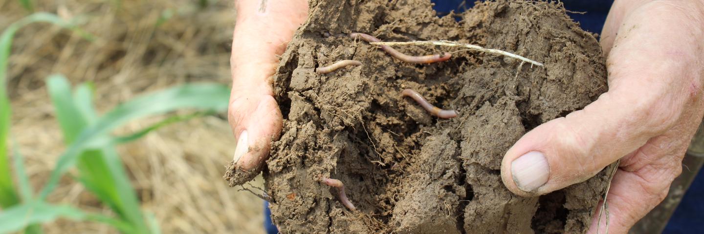
The Fayette series consists of very deep, well drained soils formed in loess. These soils are on convex crests, interfluves and side slopes on uplands and on treads and risers on high stream terraces. Slope ranges from 0 to 60 percent. Mean annual air temperature is about 9 degrees C. Mean annual precipitation is about 850 millimeters.
TAXONOMIC CLASS: Fine-silty, mixed, superactive, mesic Typic Hapludalfs
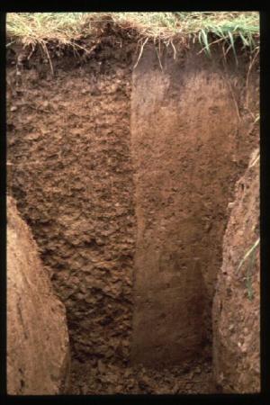
TYPICAL PEDON: Fayette silt loam, on a convex slope of 7 percent, in a woodland. (Colors are for moist soil unless otherwise stated.)
A--0 to 8 centimeters; very dark gray (10YR 3/1) silt loam, gray (10YR 5/1) dry; weak fine granular structure; very friable; many roots; few distinct light gray (10YR 7/1) dry silt coats on faces of peds; slightly acid; clear smooth boundary. (2 to 10 centimeters thick)
E1--8 to 13 centimeters; dark gray (10YR 4/1) and dark grayish brown (10YR 4/2) silt loam, light brownish gray (10YR 6/2) dry; moderate thin platy structure; very friable; common roots; moderately acid; clear smooth boundary.
E2--13 to 28 centimeters; dark grayish brown (10YR 4/2) silt loam, pale brown (10YR 6/3) dry; moderate thin platy structure; very friable; few roots; moderately acid; clear irregular boundary. (Combined thickness of the E horizon is 0 to 30 centimeters.)
BE--28 to 36 centimeters; brown (10YR 4/3) silty clay loam; moderate fine subangular blocky structure; friable; few roots; faces of peds are brown (10YR 5/3); many prominent light gray (10YR 7/1) dry silt coats on faces of peds; strongly acid; gradual smooth boundary. (0 to 15 centimeters thick)
Bt1--36 to 66 centimeters; brown (10YR 4/3) silty clay loam; strong fine and medium subangular and angular blocky structure; friable; few roots; few fine pores; common distinct clay films; few prominent light gray (10YR 7/1) dry silt coats on faces of peds; very strongly acid; clear smooth boundary.
Bt2--66 to 86 centimeters; dark yellowish brown (10YR 4/4) silty clay loam; moderate medium subangular and angular blocky structure; friable; few roots; common fine pores; common distinct clay films; few prominent light gray (10YR 7/1) dry silt coats on faces of peds; strongly acid; gradual smooth boundary. (Combined thickness of the Bt horizon is 46 to 107 centimeters.)
BC--86 to 119 centimeters; yellowish brown (10YR 5/4) silty clay loam; weak medium prismatic structure parting to weak medium angular blocky; friable; few roots; common fine pores; common distinct clay films in upper part; few black accumulations (oxides); strongly acid; gradual smooth boundary. (0 to 46 centimeters thick)
C--119 to 185 centimeters; yellowish brown (10YR 5/4) silt loam; massive with some distinct vertical faces; very friable; common fine pores; very few clay accumulations in some root channels; few dark brown concretions (oxides); few fine distinct grayish brown (10YR 5/2) redoximorphic depletions; strongly acid.
TYPE LOCATION: Major Land Resource Area (MLRA) 105-Northern Mississippi Valley Loess Hills, Fayette County, Iowa subset; about 3 miles northeast of West Union; located about 1,045 feet north and 2,594 feet east of the southwest corner of section 35, T. 95 N., R. 8 W.; USGS West Union topographic quadrangle; lat. 42 degrees 59 minutes 46.5 seconds N. and long. 91 degrees 45 minutes 17.3 seconds W., NAD 83.
RANGE IN CHARACTERISTICS:
Depth to carbonates--greater than 100 centimeters
Content of clay in the particle-size control section (weighted average)--24 to 32 percent
Content of sand in the particle-size control section (weighted average)--less than 5 percent
Coarse silt to fine silt ratio in the particle-size control section--0.9 to 1.5
A horizon:
Hue--10YR
Value--2 or 3
Chroma--1 or 2
Texture--silt loam
Clay content--15 to 27 percent
Reaction--very strongly acid to neutral
Ap horizon (if present):
Hue--10YR
Value--4
Chroma--2 or 3
Texture--silt loam
Clay content--15 to 27 percent
Reaction--very strongly acid to neutral
E horizon:
Hue--10YR
Value--4 or 5
Chroma--1 to 4
Texture--silt loam
Clay content--15 to 25 percent
Reaction--very strongly acid to slightly acid
BE horizon:
Hue--10YR
Value--4 or 5
Chroma--3 or 4
Texture--silt loam or silty clay loam
Clay content--22 to 28 percent
Reaction--very strongly acid to slightly acid
Bt horizon:
Hue--10YR
Value--4 or 5
Chroma--3 to 6
Texture--silty clay loam or silt loam
Clay content--24 to 32 percent
Reaction--very strongly acid to slightly acid
Some pedons have subhorizons that have a clay content of up to 35 percent
BC and C horizons:
Hue--10YR
Value--4 or 5
Chroma--4 to 6
Texture--silt loam or silty clay loam
Clay content--20 to 30 percent
Reaction--very strongly acid to slightly alkaline
Some pedons have relict redoximorphic features below a depth of 75 centimeters, with hue of 10YR or 2.5Y, value of 4 or 5, and chroma of 2 to 6
COMPETING SERIES:
Bertrand, Blackhammer, Camden, Dodge, Dubuque, Flagg, Greenridge, Hackers, Jackson, Jemerson, Knowles, La Farge, Lambeau, Lomira, Martinsburg, Menfro, Middletown, Navlys, Palermo, Palsgrove, Pepin, Piscasaw, Ridgway, Rozetta, Ruma, Rush, Russell, Seaton, St. Charles, Stookey, Sylvan, Thebes, and Yellowriver series.
Bertrand--have a sand content of more than 85 percent with 0 to 5 percent rock fragments in the lower third of the series control section
Blackhammer--have a rock fragment content, mostly chert and sandstone, of 5 to 35 percent in the lower third of the series control section
Camden--have a sand content of 15 to 65 percent in the lower third of the series control section
Dodge--have carbonates within a depth of 100 centimeters and have a calcium carbonate equivalent range of 10 to 40 percent in the lower third of the series control section
Dubuque--have a lithic contact of dolomitic limestone within a depth of 100 centimeters
Flagg--have matrix hues of 2.5YR, 5YR, or 7.5YR and have a sand content of more than 15 percent in the lower third of the series control section
Greenridge--have matrix hues of 5Y, 5YG, 10GY, or 5G in the lower third of the series control section
Hackers--have matrix hues of 2.5YR or 5YR and have stratified layers in the lower third of the series control section
Jackson--have stratified layers with a sand content of more than 80 percent in the lower third of the series control section and have a frequently saturated zone at a depth of 1 meter during the wettest periods of normal years
Jemerson--have an average clay content of 22 to 27 percent and an average sand content of 5 to 15 percent in the particle-size control section
Knowles--have a lithic contact of dolomitic limestone within a depth of 100 centimeters
La Farge--have a paralithic contact of glauconitic sandstone within a depth of 100 centimeters and have an average clay content of 18 to 27 percent in the particle-size control section
Lambeau--have a sand content of more than 20 percent in the lower one third of the series control section and have a paralithic contact of siliceous sandstone within a depth of 200 centimeters
Lomira--have carbonates within a depth of 100 centimeters
Martinsburg--have an average clay content of 27 to 35 percent and an average sand content of less than 15 percent in the particle-size control section and have ochric epipedons 46 to 74 centimeters thick
Menfro--are in areas that have a mean annual air temperature range of 12 to 15 degrees C and have a mean annual precipitation range of 810 to 1,070 millimeters
Middletown--have an average clay content of more than 27 percent in the particle-size control section and have a sand content of more than 80 percent in the lower third of the series control section
Navlys--have carbonates within a depth of 100 centimeters, have an average clay content of 25 to 35 percent in the particle-size control section, and have a frequently saturated zone at a depth of 1.2 meters during the wettest period of normal years
Palermo--have ochric epipedons 8 to 15 centimeters thick and are in areas that have a mean annual air temperature range of 12 to 13 degrees C and have a mean annual precipitation range of 910 to 970 millimeters
Palsgrove--have a lithic contact of dolomitic limestone within a depth of 150 centimeters and have an average clay content of 27 to 35 percent in the particle-size control section
Pepin--have a lithic contact of dolomitic limestone within a depth of 200 centimeters and have an average clay content of 18 to 27 percent in the particle-size control section
Piscasaw--have carbonates within a depth of 150 centimeters and have a sand content of 35 to 55 percent in the lower third of the series control section
Ridgway--have a sand content of more than 60 percent with lamellae in the lower third of the series control section
Rozetta--have an average clay content of 27 to 35 percent in the particle-size control section and have a frequently saturated zone at a depth of 1.2 meters during the wettest periods of normal years
Ruma--have a clay content of 15 to 27 percent and a sand content of 7 to 15 percent in the lower third of the series control section and are in areas that have mean annual air temperature range of 12 to 14 degrees C and have a mean annual precipitation range of 910 to 1,020 millimeters
Rush--have a rock fragment content of 15 to 75 percent in the lower third of the series control section
Russell--have a carbonates within a depth of 150 centimeters and have moist bulk density of 1.75 to 2.00 g/cc in the lower third of the series control section
Seaton--have an average clay content of 18 to 24 percent in the particle-size control section and have a coarse silt to fine silt ratio of 1.5 to 2.5 in the in the particle-size control section
St. Charles--have stratified layers with a clay content of 10 to 25 percent and a sand content of from 20 to 60 percent the lower third of the series control section
Stookey--have an average clay content of 18 to 27 percent in the particle-size control section, have a coarse silt to fine silt ratio of 1.5 or greater, and are in areas that have a mean annual air temperature range of 12 to 14 degrees C and have a mean annual precipitation range of 910 to 1,120 centimeters
Sylvan--have carbonates within a depth of 100 centimeters and have an average clay content of 25 to 35 percent and an average sand content of less than 15 percent in the particle-size control section
Thebes--have an average sand content of more than 50 percent in the lower third of the series control section
Yellowriver--have a sand content of 10 to 50 percent in the upper part of the series control section
GEOGRAPHIC SETTING:
Parent material--loess
Landform--convex crests, interfluves and side slopes on uplands and on treads and risers on high stream terraces
Slope--0 to 60 percent
Elevation--200 to 460 meters above sea level
Mean annual air temperature--7 to 12 degrees C
Mean annual precipitation--730 to 970 millimeters
Frost-free period--145 to 180 days
GEOGRAPHICALLY ASSOCIATED SOILS:
Downs, Dubuque, Exette, and Nordness soils.
Downs--are in landscape positions similar to those of the Fayette soils and have surface layers 15 to 23 centimeters thick
Dubuque--are at lower elevations on side slopes and have a lithic contact within a depth of 100 centimeters
Exette--are at lower elevations on side slopes and head slopes and have an average clay content of 20 to 27 percent in the particle-size control section
Nordness--are at lower elevations on side slopes and have a lithic contact within a depth of 50 centimeters
DRAINAGE AND PERMEABILITY:
Drainage class--well drained--saturation does not occur within a depth of 1.8 meters during the wettest periods of normal years
Saturated hydraulic conductivity--1.00 to 10.00 micrometers per second (moderately high)
Surface runoff potential--negligible to high
USE AND VEGETATION:
Nearly level to gently sloping areas are cultivated. The principal crops are corn, soybeans, small grains, and legume hays. Steeper slopes are pastured, wooded or both wooded and pastured. The native vegetation is deciduous trees, mainly oak and hickory.
DISTRIBUTION AND EXTENT:
Physiographic Division--Interior Plains
Physiographic Province--Central Lowland
Physiographic sections--Eastern lake section, Wisconsin driftless section, Dissected till plains, and Till plains
MLRAs--Southern Wisconsin and Northern Illinois Drift Plain (95B),
Eastern Iowa and Minnesota Till Prairies (104),
Northern Mississippi Valley Loess Hills (105),
Illinois and Iowa Deep Loess and Drift (108),
Iowa and Missouri Heavy Till Plain (109),
Southern Illinois and Indiana Thin Loess and Till Plain (114), and
Central Mississippi Valley Wooded Slopes (115)
LRR M and LRR L; eastern Iowa, southeastern Minnesota, southwestern Wisconsin, and northwestern Illinois
Extent--large
MLRA SOIL SURVEY REGIONAL OFFICE (MO) RESPONSIBLE: St. Paul, Minnesota
SERIES ESTABLISHED: Fayette County, Iowa, 1919.
REMARKS:
Particle-size control section--the zone from a depth of 36 to 86 centimeters (Bt1 and Bt2 horizons);
series control section--the zone from the surface to a depth of 150 centimeters (A, E1, E2, BE, Bt1, Bt2, BC, and C horizons).
Diagnostic horizons and features recognized in this pedon:
ochric epipedon--the zone from the surface to a depth of 36 centimeters (A, E1, E2 and BE horizons);
albic horizon--the zone from a depth of 8 to 28 centimeters (E1 and E2 horizons);
argillic horizon--the zone from a depth of 36 to 86 centimeters (Bt1 and Bt2 horizons);
udic moisture regime.
The thickness of the A and E horizons, depth to subhorizon highest in clay content, maximum percent clay thickness of the Bt horizon, depth to carbonates, and depth to redoximorphic features usually decrease as gradient increases on convex slopes.
Cation-exchange activity class is supported by lab data from National Soil Survey Laboratory, Lincoln, Nebraska.
Clay content in the particle-size control section and lower third of the series control section is based on analysis of laboratory data (NSSL)
Taxonomy version--Keys to Soil Taxonomy, tenth edition, 2006.
ADDITIONAL DATA:
Laboratory data--National Soil Survey Laboratory, Lincoln, Nebraska, many pedons (http://ssldata.sc.egov.usda.gov/)
National Cooperative Soil Survey
U.S.A.