
CATLIN SERIES
LOCATION IL
Established Series
Rev. JCD-SLE-AAC
07/2013
The Catlin series consists of very deep, moderately well drained soils on till plains. These soils formed in loess or other silty material and in the underlying loamy calcareous till. Slope ranges from 0 to 15 percent. The mean annual temperature is 8.3 degrees C (47 degrees F), and the mean annual precipitation is 890 mm (35 inches).
TAXONOMIC CLASS: Fine-silty, mixed, superactive, mesic Oxyaquic Argiudolls
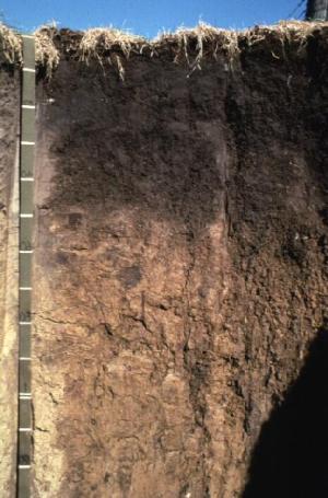
TYPICAL PEDON: Catlin silt loam on a southwest-facing 2 percent slope in a cultivated field at an elevation of 253 meters (830 feet) above mean sea level. (Colors are for moist soil unless otherwise stated.)
Ap--0 to 28 cm (0 to 11 inches); very dark brown (10YR 2/2) silt loam, grayish brown (10YR 5/2) dry; moderate fine granular structure; friable; neutral; abrupt smooth boundary. [25 to 51 cm (10 to 20 inches) thick]
BA--28 to 46 cm (11 to 18 inches); brown (10YR 4/3) silt loam; weak medium prismatic structure parting to moderate fine and medium subangular blocky; friable; few faint dark brown (10YR 3/3) organic coatings on faces of peds; common distinct light gray (10YR 7/1) (dry) silt coatings on faces of peds; moderately acid; clear smooth boundary. [0 to 20 cm (0 to 8 inches) thick]
Bt1--46 to 58 cm (18 to 23 inches); brown (10YR 5/3) silty clay loam; weak medium prismatic structure parting to strong fine and medium subangular blocky; friable; many faint brown (10YR 4/3) clay films on faces of peds; few distinct light gray (10YR 7/1) (dry) silt coatings on faces of peds; strongly acid; clear smooth boundary.
Bt2--58 to 79 cm (23 to 31 inches); yellowish brown (10YR 5/4) silty clay loam; moderate medium prismatic structure parting to strong medium angular and subangular blocky; firm; few distinct very dark brown (10YR 2/2) organo-clay films on surfaces along root channels; many faint brown (10YR 4/3) clay films on faces of peds; few distinct light gray (10YR 7/1) (dry) silt coatings on faces of peds; few black (N 2.5/) weakly cemented iron-manganese concretions throughout; few fine faint brown (7.5YR 4/4) masses of oxidized iron-manganese and common fine distinct yellowish brown (10YR 5/6) masses of oxidized iron in the matrix; moderately acid; clear smooth boundary.
Bt3--79 to 91 cm (31 to 36 inches); yellowish brown (10YR 5/4) silty clay loam; strong medium prismatic structure parting to strong medium angular and subangular blocky; firm; common prominent grayish brown (2.5Y 5/2) clay films on faces of peds; few distinct light gray (10YR 7/1) (dry) silt coatings on faces of peds; few black (N 2.5/) weakly cemented iron-manganese concretions throughout; few fine faint brown (7.5YR 4/4) extremely weakly cemented iron-manganese accumulations and distinct yellowish brown (10YR 5/6) masses of oxidized iron in the matrix; slightly acid; clear smooth boundary.
Bt4--91 to 112 cm (36 to 44 inches); yellowish brown (10YR 5/4), brown (7.5YR 4/4), and light brownish gray (2.5Y 6/2) silty clay loam; weak coarse prismatic structure parting to moderate coarse subangular blocky; firm; many faint grayish brown (2.5Y 5/2) clay films on faces of peds; common distinct light gray (10YR 7/1) (dry) silt coatings on faces of peds; few distinct very dark brown (10YR 2/2) organo-clay films on surfaces along root channels; slightly acid; abrupt smooth boundary. [Combined thickness of the Bt horizon is 64 to 107 cm (25 to 42 inches).]
2Bt5--112 to 124 cm (44 to 49 inches); dark yellowish brown (10YR 4/4) clay loam; weak coarse subangular blocky structure; firm; few faint brown (10YR 5/3) clay films on vertical faces of peds; few distinct very dark brown (10YR 2/2) organo-clay films on surfaces along root channels; slightly alkaline; clear smooth boundary. [13 to 51 cm (5 to 20 inches) thick]
2C--124 to 152 cm (49 to 60 inches); yellowish brown (10YR 5/4) loam; massive; firm; common fine distinct yellowish brown (10YR 5/6) masses of oxidized iron in the matrix; 5 percent gravel; strongly effervescent; moderately alkaline.
TYPE LOCATION: Ogle County, Illinois; about 1 1/2 miles south and 2 1/2 miles east of Monroe Center; 650 feet south and 571 feet east of the northwest corner of sec. 36, T. 42 N., R. 2 E.; USGS Fairdale topographic quadrangle; lat. 42 degrees 04 minutes 38 seconds N., and long. 88 degrees 57 minutes 17 seconds W., UTM Zone 16338307 Easting and 4660199 Northing; NAD83.
RANGE IN CHARACTERISTICS:
Thickness of mollic epipedon: 25 to 51 cm (10 to 20 inches)
Depth to carbonates: 102 to 152 cm (40 to 60 inches)
Depth to horizons with more than 15 percent sand (loess or other silty material): 102 to 152 cm (40 to 60 inches)
Depth to the base of soil development: 114 to 165 cm (45 to 65 inches)
Particle-size control section: averages 27 and 35 percent clay
Ap, A, and/or AB horizons:
Hue: 10YR
Value: 2 or 3
Chroma: 1 to 3
Texture: silt loam or silty clay loam
Clay content: averages 18 to 32 percent
Sand content: averages 0 to 8 percent
Reaction: strongly acid to neutral
BA horizon (where present):
Hue: 10YR or 2.5Y
Value: 3 to 5
Chroma: 3 or 4
Texture: silt loam or silty clay loam
Bt horizon:
Hue: 10YR or 2.5Y
Value: 3 to 5
Chroma: 3 or 4
Texture: commonly silty clay loam, but ranges to silt loam in upper and/or lower subhorizons of some pedons.
Clay content: averages 24 to 35 percent
Sand content: averages 0 to 8 percent
Reaction: strongly acid to neutral
2Bt, 2BC, and/or 2C horizons:
Hue: 10YR, 2.5Y or 7.5YR
Value: 4 or 5
Chroma: 2 to 8
Texture: clay loam, loam, silty clay loam or silt loam
Clay content: averages 20 to 35 percent
Sand content: averages 15 to 40 percent
Gravel content: less than 10 percent
Reaction: slightly acid to moderately alkaline
COMPETING SERIES:
Assumption, Aviston, Barrington, Blackberry, Buckhart, Clare, Dana, Danabrook, Geryune, Graymont, Harrison, Keltner, Saybrook, and Totanang soils. Assumption and Harrison soils do not have carbonates within a depth of 152 cm (60 inches). Aviston soils have less than 15 percent sand in the lower part of the series control section. Barrington, Blackberry, and Clare soils have horizons in the middle or lower part of the series control section with sand content greater than 40 percent. Buckhart soils have less than 7 percent sand throughout the series control section. Dana, Danabrook, Geryune, Graymont and Saybrook soils have horizons with more than 15 percent sand within a depth of 102 cm (40 inches). Keltner soils have a paralithic contact within a depth of 152 cm (60 inches). Totanang soils have more than 10 percent rock fragments in the lower part of the series control section.
GEOGRAPHIC SETTING: Catlin soils are on relatively undissected loess covered till plains. Slopes typically are between 3 and 7 percent, but range from 0 to 15 percent and are convex. Catlin soils formed in 102 to 152 cm (40 to 60 inches) of loess or other silty material and in the underlying loamy calcareous till. The mean annual air temperature ranges from 7.8 to 12.8 degrees C (46 to 55 degrees F), mean annual precipitation ranges from 864 to 1067 mm (34 to 42 inches), frost free period ranges from 150 to 190 days, and elevation ranges from 180 to 305 meters (590 to 1000 feet) above sea level.
GEOGRAPHICALLY ASSOCIATED SOILS:
These are the competing Saybrook soils and the Drummer, Elburn, Flanagan, and Plano soils. The poorly drained Drummer soils and the somewhat poorly drained Flanagan soils are on lower lying parts of the landscape and form a drainage sequence with Catlin soils. The Plano and somewhat poorly drained Elburn soils are on adjacent or nearby outwash plains. Saybrook soils are on similar nearby landscapes where the loess mantle is thinner.
DRAINAGE AND SATURATED HYDRAULIC CONDUCTIVITY: Moderately well drained. A perched seasonal high water table is 61 to 107 cm (2.0 to 3.5 feet) below the surface at some time between February and April in most years. The potential for surface runoff is low or medium. Saturated hydraulic conductivity is moderately high to high (4.23 to 14.11 micrometers per second) in the solum and moderately high (1.41 to 4.23 micrometers per second) in the underlying material. Permeability is moderate in the solum and moderately slow in the underlying material.
USE AND VEGETATION: Almost all areas used to grow corn and soybeans. Native vegetation is prairie grass.
DISTRIBUTION AND EXTENT: Catlin soils are in central and northern Illinois. LRR M, MLRAs 95B, 108A, 108B, 110, and 115C. They are of large extent (more than 305,000 acres are correlated).
MLRA SOIL SURVEY REGIONAL OFFICE (MO) RESPONSIBLE: Indianapolis, Indiana
SERIES ESTABLISHED: Vermilion County, Illinois, 1932.
REMARKS: Diagnostic horizons and features recognized in this pedon are:
mollic epipedon - from a depth of 0 to 28 cm (0 to 11 inches) (Ap horizon);
argillic horizon - from a depth of 46 to 124 cm (18 to 49 inches) (Bt1, Bt2, Bt3, Bt4, and 2Bt5 horizons):
lithologoical discontinuity - at a depth of 112 cm (44 inches) (contact between the Bt4 and 2Bt5 horizons).
National Cooperative Soil Survey
U.S.A.