
Shortfoot Creek Watershed Plan
Shortfoot Creek Watershed Plan
DRAFT WATERSHED PLAN - ENVIRONMENTAL IMPACT STATEMENT (EIS) SHORTFOOT CREEK WATERSHED, SITE 7
The purposes of the proposed action are flood damage reduction and watershed protection.
Shortfoot Creek watershed is a part of the Wild Rice River basin and the Red River Basin which have histories of spring snow melt and seasonal rains resulting in frequent overland and overbank flooding, resulting in recurring damages. The flooding causes disruptions to transportation by overtopping and washing out roads, and damaging bridges and culverts. This flooding also inundates an average of 2,189 acres annually which results in high transportation of nutrients to the Wild Rice River due to upland and channel erosion, flushing nutrients, crop losses, and delayed planting. The Shortfoot Creek watershed annually contributes 15,548 pounds of phosphorus and 70,176 pounds of nitrogen to the Wild Rice River and ultimately the Red River, for which U.S. agreed to nutrient objectives at the international border have not been achieved. Dissolved inorganic phosphorus is of particular concern, given that annual loads and concentrations have been on an upward trend since the early 1980s.
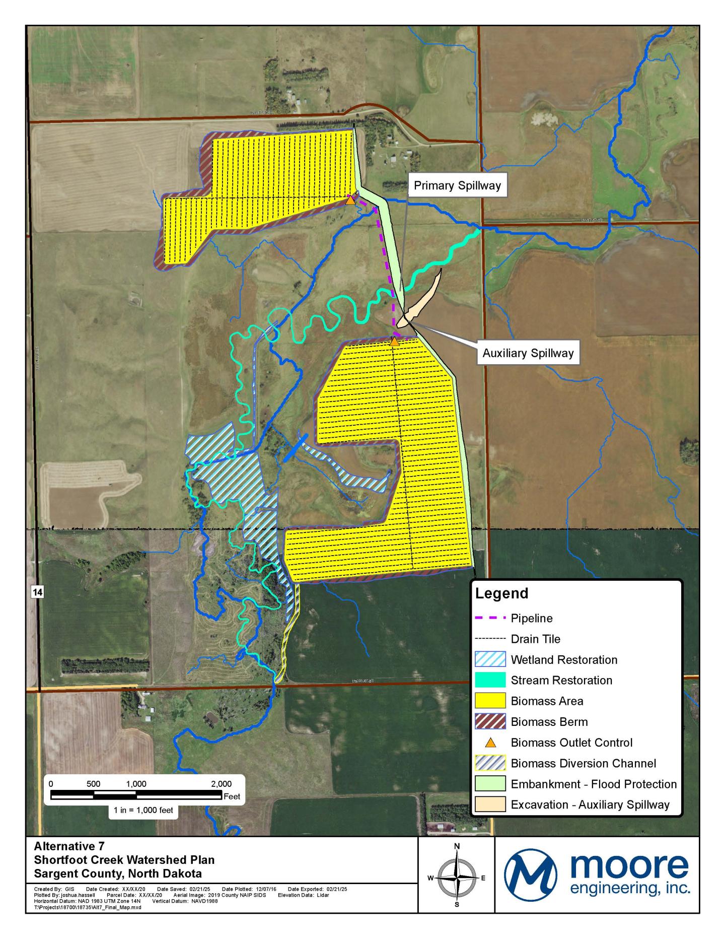
The proposed action includes the construction of a multi-purpose dry dam with incorporated features to reduce nutrient delivery from the upstream watershed; reduce the extents, frequency, and duration of downstream cropland flooding to further reduce nutrient transport to the river; and to restore, enhance and create wetland and upland wildlife habitat. Shortfoot Creek Site 7 will entail construction of a 6,100-foot earthen embankment dam and associated spillways. Within the interior of the dry dam, the project will develop 130 acres of shallow water biomass harvest areas managed to optimize nutrient removal. A 2.64 mile stretch of Shortfoot Creek will be restored to its original path, resulting in maintaining or restoring 230.5 acres of wetlands and 101.5 acres of uplands managed for wildlife habitat.
Current Status
The plan has recently been determined to require an EIS instead of an EA. A Notice of Intent to prepare an EIS was published to the the Federal Register on June 25, 2025. NRCS is requesting comments to identify significant issues, potential alternatives, information, and analyses relevant to the proposed action from all interested individuals, Federal and State agencies and Tribes. All comments must be received by August 11, 2025. Comments may be submitted at the Portal : http://www. regulations.gov, docket ID NCS-2025-0003, or mail comments to Jonathan Petersen, USDA-NRCDS, 220 E. Rosser Ave., Bismarck, ND 58502-1458.
A public scoping meeting was held on March 27, 2025, in Forman, ND for the Shortfoot Creek Watershed Plan sponsored by the Sargent Count Water Resources District. A Recording is available at: https://youtu.be/0k3yVJnAu3k. Stakeholders may also download and complete the survey below. The survey may be mailed to the sponsor or to Jonathan Petersen at the above address.