
Fiscal Year 2024 State of Connecticut Soil Survey Updates
The USDA NRCS, Soil and Plant Science Division refreshes the publicly available soil survey database once a year. This Annual Soils Refresh (ASR) provides new soils data, updates to existing soils data, and new soil interpretations. The ASR also ensures all official soils data adhere to the same standards.
This year’s update to soil survey data in the State of Connecticut brings marked changes. A summary of these changes is listed here:
- Updated Farmland of Statewide Importance criteria To help maintain the productive capacity of American agriculture, the U.S. Department of Agriculture’s Natural Resources Conservation Service (NRCS) has developed criteria and guidelines to inventory important farmlands. Earlier this year, Connecticut NRCS proposed to update its farmland designation criteria for Farmland of Statewide Importance to allow for “not more than 3 percent of the soil surface is covered by stones 10 in (25 cm) to 24 in (60 cm) diameter.” This change would allow for some very stony soil map units to be designated as Farmland of Statewide Importance. The result of these changes is a more equitable designation across Connecticut, as these designations are used to assess eligibility and ranking for certain USDA program benefits. Further, the new designations are consistent with criteria/designations in other states of our region such as Massachusetts.
These farmland designation criteria changes result in the following changes to the Soil Survey of the State of Connecticut:
- 339,153 acres changed to Farmland of Statewide importance.
- Some of this acreage was previously designated as Locally Important Farmland in select towns. This change to Farmland of Statewide importance supersedes the Locally Important Farmland designation, resulting in a more equitable designation across the state as these designations are used to assess eligibility and ranking for certain USDA program benefits.
- 8 map units currently designated as Locally Important Farmland in select towns would not be changed to Farmland of Statewide Importance, so the Locally Important designation does not become obsolete as a result of the proposed change.
These unchanged map units are associated with bedrock-controlled landforms. Connecticut and Massachusetts currently have consistent farmland designation criteria as related to amount of bedrock outcrop/exposures.
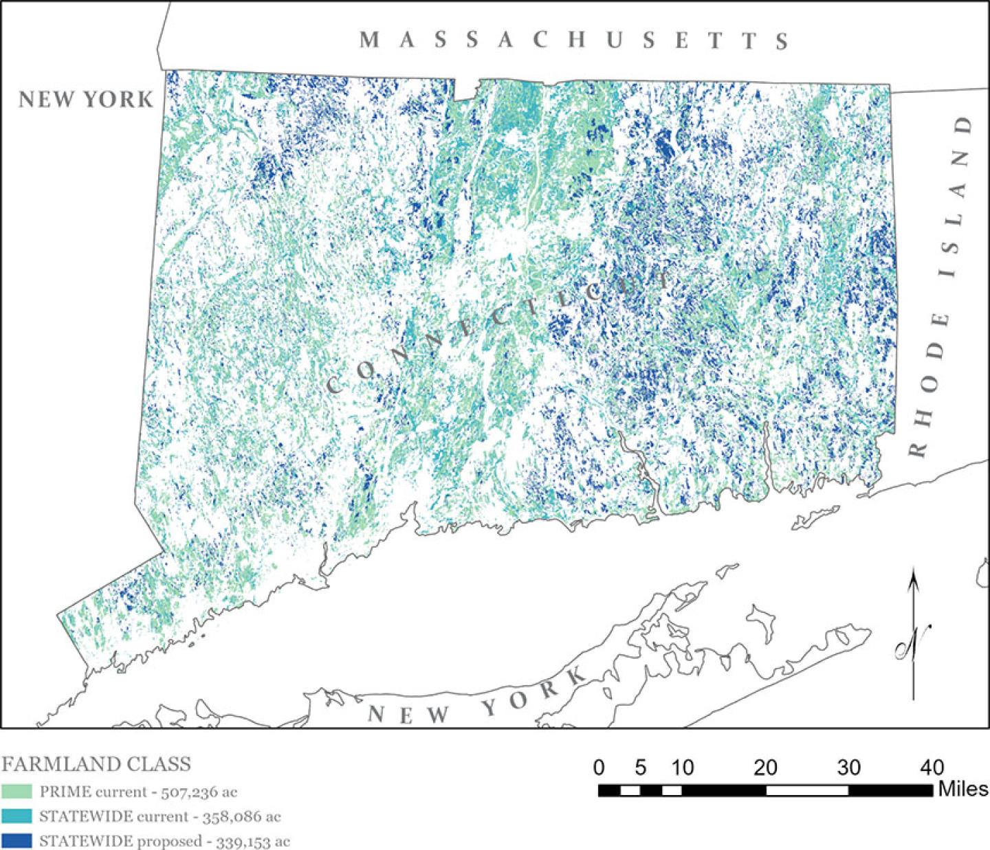
Figure 1. The darker blue areas labeled “STATEWIDE proposed” are now considered Farmland of Statewide Importance in the FY24 soil survey data.
2. Updates to Water Table Data for Moderately Well Drained Soils
Soil water table data for some Moderately Well Drained (MWD) components in the Soil Survey for the State of Connecticut was inconsistent and, in some cases, not accurately matching soil morphology of the respective typical pedon. Additionally, the MWD components were inconsistent as to whether the month of May was included as a month with the seasonal high water table depth. A review of available water table data suggested May should be populated as a month with a high-water table in all cases. Many of our MWD soils were only populated through April.
Updates to the water table data will affect soil interpretation results as well as some commonly used interpretive groups such as Hydrologic Soil Groups. The following soil components have altered hydrologic soil group designations in the soil survey as a result of the water table edits: Amenia, Ashfield, Belgrade, Berlin, Brancroft, Ellington, Elmridge, Georgia, Hero, Ludlow, Ninigret, Pootatuck, Rainbow, Raypol, Schroon, Sudbury, Tisbury, Wapping, Watchaug, and Winooski.
A summary document of HSG values for previous years and the new data is available here.
3. Connecticut Soil Survey Area Split into Western and Eastern Parts
Users that download the spatial and tabular soil survey data for use in GIS and/or Access will notice a significant change to how the Connecticut data is packaged. Due to new data serving limitations, the State of Connecticut (statewide) soil survey area (symbolized as CT600) needed to be split into at least two parts. The former and current soil survey areas are shown below for illustration.
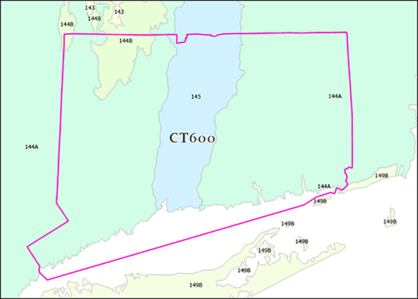
Figure 3.1. Former Soil Survey Area boundary for CT600 (Soil Survey of the State of Connecticut) with MLRA boundaries
Figure 3.2. New Soil Survey Area boundaries; CT601 (Soil Survey of the State of Connecticut, Western Part) and CT602 (Soil Survey of the State of Connecticut, Eastern Part)
The new data can be downloaded by visiting Web Soil Survey, click “Start WSS”, select “Download Soils Data” tab, and filter by state.
4. Newly Correlated Soil Series: Pollux and Amostown soils
Pollux and Amostown soil series were correlated within the Connecticut Valley in multiple Massachusetts soil survey areas, and are now correlated to Soil Surveys in the State of Connecticut as a result of soil survey update activities in Keney Park and Matianuck Preserve that were completed during 2023. The Pollux and Amostown series consist of very deep soils formed in loamy glacial outwash overlying glaciolacustrine sediments. Pollux is well drained and Amostown is moderately well drained. They are nearly level to strongly sloping soils on glaciofluvial plains or deltas.
An Updated Soil Catenas of Connecticut document that includes Pollux and Amostown soils can be found here.
If you have any questions about new edits to Connecticut soil survey data, please contact Jacob Isleib at Jacob.isleib@usda.gov.