May 1st Outlook: Early Melt, Below Normal Snowpack, Low Runoff and Mixed Reservoir Conditions
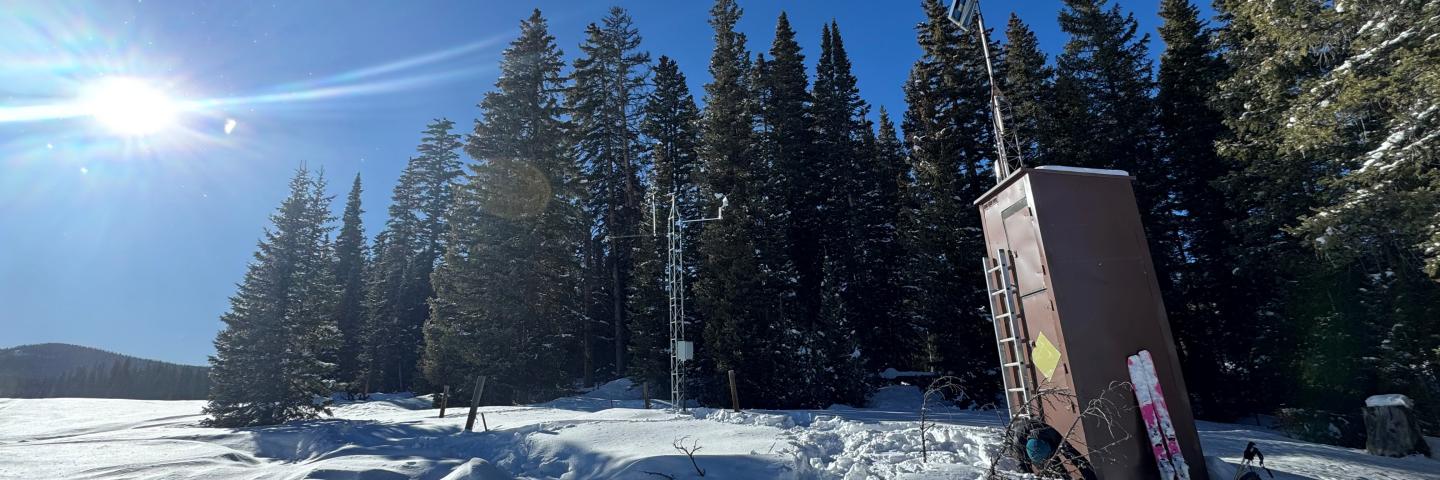
Snowpack across Colorado is well below normal following a warm, dry April. Statewide snowpack has begun its seasonal decline, with SWE at 57% of median. Despite a dry April, early May storms brought helpful precipitation to higher elevations.
Denver, CO – May 7th, 2025 – As of May 1st, Colorado’s snowpack peaks and begins its seasonal decline. Statewide snow water equivalent (SWE) is at 57% of median, reflecting a sparse and well below average snowpack with drier conditions in central, southwest and southeast basins. In the Gunnison, combined San Miguel-Dolores-Animas-San Juan (SMDASJ), Upper Rio Grande (URG) and Arkansas snowpack is at 34% of median. Northern basins are at 73% of median with higher snowpacks in northeast mountains.
Statewide peak SWE occurs 11 days earlier than the historical median with 90% of sites observing earlier dates. April brings limited storm activity, making for a less eventful month and resulting in a -28% SWE departure of the 30-year median. That negative departure translates to a decline of 2.6 inches of SWE at 82% of sites over the past 30 days. Looking at the full accumulation season from late October through April, the cumulative SWE departure deepens to 5.5 inches.
May began with a strong storm system delivering over 3 inches of moisture at some sites in the Sangre de Cristos and San Juans, including the SMDASJ, URG and Arkansas River basins. The Front Range mountains are also benefitting from the early May storm, primarily east of the divide. Southwest basins typically receive around 7% of their annual precipitation in May, much of which falls as snow at higher elevations. During spring, however, this precipitation can fall as rain on snowpack unless temperatures cool significantly. “With this recent storm cooler temperatures prevailed, resulting in observed snowfall in many high elevation sites. While this early May storm did not benefit all regions equally, the widespread drop in temperatures will help reduce melt rates and slow runoff timing across the state,” notes Nagam Bell, NRCS hydrologist.
Water year to date (WYTD) precipitation is at 85% of median statewide, with basin values ranging from 74 to 95 percent. Northern basins lead the state with drier conditions found in the URG (74%) and SMDASJ (77%), while the Gunnison and Arkansas measure 82 and 86 percent of median, respectively. April finishes as the driest month for the primary accumulation period with statewide totals at 59% of median. Northern and central basins fall well below average: Yampa-White-Little Snake end at 43%, Colorado Headwaters at 47% and Gunnison at 49%. Southern basins fair slightly better over the last 30 days: SMDASJ reports 75% and the URG 70% for the month. Sixty day precipitation trends show a modest bump in some areas. Laramie-North Platte reaches 84% and the SMDASJ reports 88% of median.
On the lower end, the Arkansas and URG observe 66 and 73 percent, respectively. The 90 day averages highlight increased variation, spanning 64 to 98 percent. Northern basins remain the strongest performers while precipitation values taper farther southeast. The following charts highlight statewide totals (see Figure 1) and departures from median. November remains the only month with a notable surplus, while April records the steepest drop at 44% below normal (see Figure 2).
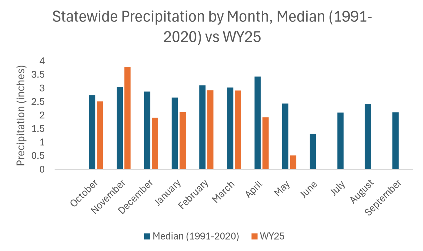
Figure 1. Statewide monthly precipitation totals comparing the 1991-2020 median with Water Year 2025. May totals reflect values through May 5th and are not yet complete.
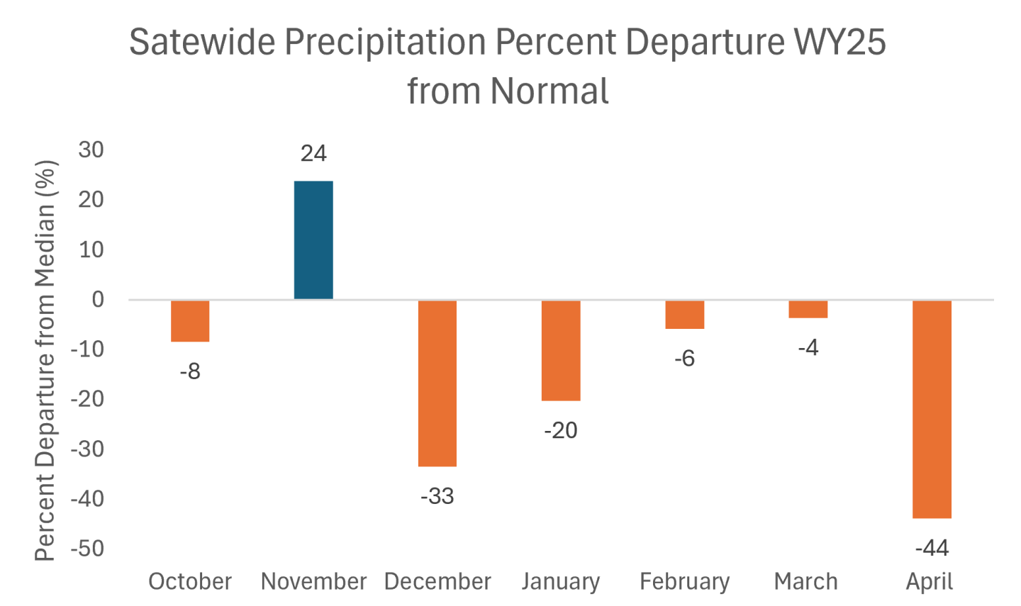
Figure 2. Percent departure from median precipitation by month for Water Year 2025. November records a surplus and April has the largest negative departure. October, February and March observe closer to normal precipitation.
Statewide reservoir storage is at 93% of median and 61% of total capacity as of the end of April. Despite below average snowpack storage levels at most higher capacity reservoirs are holding near or above average volumes and include: Dillon, Lake Granby, Blue Mesa and Pueblo Reservoir. The exceptions are McPhee at 73% of median and 62% capacity and Navajo Reservoir at 74% of median and 61% capacity.
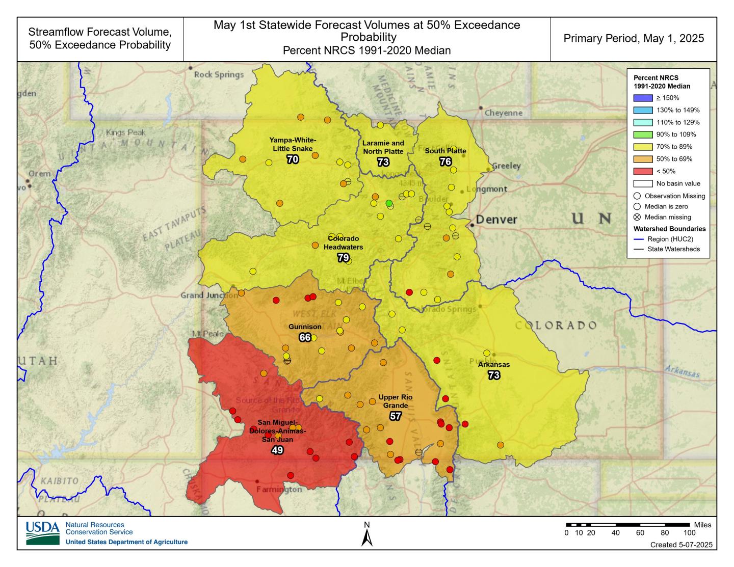
Streamflow forecasts continue to reflect widespread degradation heading into the remaining runoff period. The exception is a handful of points remaining closer to normal that are clustered northwest of the divide in the Colorado Headwaters. The lack of April moisture and precipitation deficits from primary accumulation months compounded by an early and accelerated snowmelt, particularly in southern basins, limits streamflow potential through the remainder of the forecast season based on conditions leading into the May 1 forecast.
As of early May, 24% of Colorado SNOTEL sites have reached melt out primarily in the southern basins. These sites melted out an average of 16 days earlier, with the median statewide melt out date on May 24th. “Lower snowpack volumes and increased temperatures drive early melt, which translates into earlier and likely lower peak streamflow. The potential result is a compressed runoff window and in many cases a muted response in flows,” notes Bell. Soil moisture data further supports these trends, with snowmelt signals registered throughout soil stacks across most basins.
Statewide, the 50% exceedance forecasts are at 71% of median with 86 forecast points averaging in the 19th percentile. Basins in the Upper Colorado Region that make up the Colorado western slope are at 72% of median forecasts. All 50% probabilities show a negative departure from median volumes with lowest outlooks in the southwest region ranging from 49% in the SMDASJ, 57% in the URG and 66% in the Gunnison. Streamflow’s in the Arkansas are at 73% of median with higher output points ranging from 71% of median at Pueblo Reservoir inflow to 85% of median at the Arkansas River at Salida. These suppressed forecasts reflect the combined effects of limited April precipitation, early and accelerated snowmelt, and low antecedent water year precipitation.
As the season progresses and fewer forecasts updates remain the range of forecasted outcomes narrows and uncertainty decreases as late season inputs come in. In general, most exceedance values remain low and can be compared for the entire forecast season at each point using the evolution forecast plots. In years like this the drier forecast range, including the 90% exceedance, can be especially informative. If dry conditions persist, these lower projections may prove most reflective of what materializes. It’s essential to consider the full range of forecast probabilities, not just the median, when planning around potential runoff outcomes.
Colorado’s Snowpack and Reservoir Storage as of May 1st, 2025
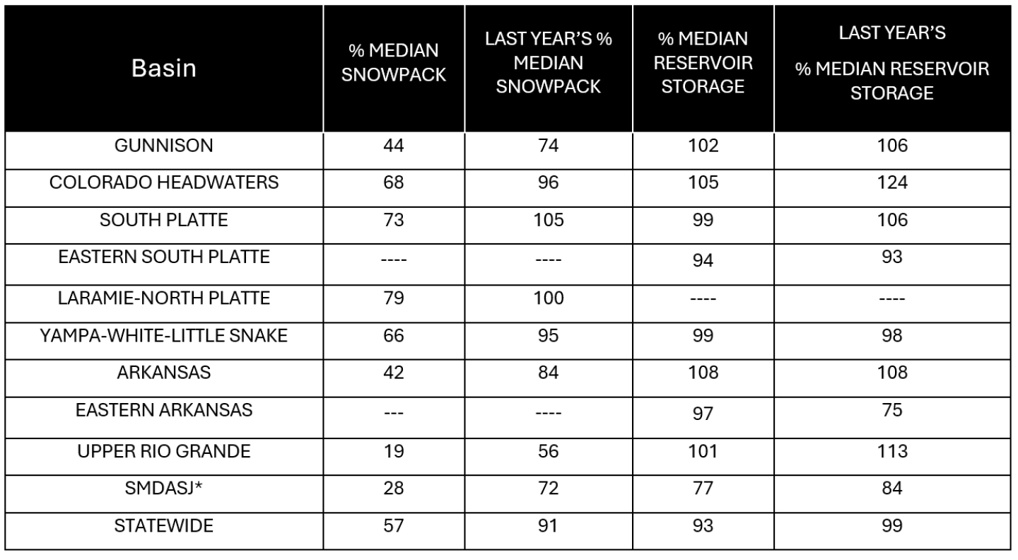
* San Miguel-Dolores-Animas-San Juan River basin*
*For more detailed information about January mountain snowpack refer to the May 1st, 2025 Colorado Water Supply Outlook Report. For the most up to date information about Colorado snowpack and water supply related information, refer to the Colorado Snow Survey website.


