The Soil and Water Resources Conservation Act (RCA) of 1977, as amended, provides the United States Department of Agriculture (USDA) broad strategic assessment and planning authority for the conservation, protection, and enhancement of soil, water, and related natural resources.
Through RCA, USDA:
- appraises the status and trends of soil, water, and related resources on non-Federal land and assesses their capability to meet present and future demands;
- evaluates current and needed programs, policies, and authorities; and
- develops a national soil and water conservation program to give direction to USDA soil and water conservation activities.

RCA Data Viewer
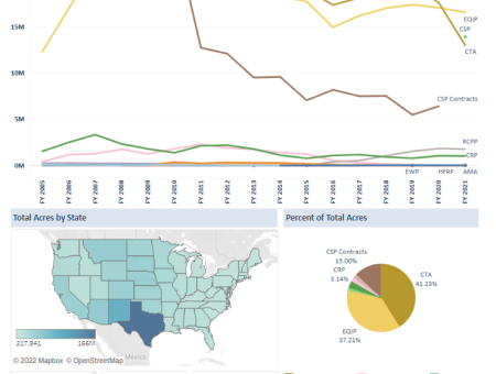
New data visualization tools are now available on the RCA Data Viewer. Users can graph, map, and download customized datasets based on practices applied through NRCS programs and survey data on land use, soil erosion, and prime farmland from the National Resources Inventory (NRI).
RCA Related Data and Publications

Conservation Practices and Programs
- Acres Receiving Conservation through NRCS Programs for fiscal years 2005-2021, by conservation program or NRCS performance measure. Land unit (field) acres and practice counts are available for every practice. Users can filter, graph, map, and download data by state, fiscal year, and program.
- Practices Applied through NRCS Programs, fiscal years 2005-2021. Land unit (field) acres and practice counts are available for every conservation practice. Users can graph, map, and download data on after filtering by practice, state, fiscal year, program, and land use. The “Top Practices” dashboard provides data on the most widely used practices. The “Selected Practices” dashboard allows users to choose any practice or group of practices.
- NRCS Financial Assistance Program contract data for fiscal years 2014-2022. Data includes dollars obligated, contracts signed, contracts with historically underserved farmers, and conservation practices. Users can graph, map, and download data by fiscal year, state, county, congressional district, and practice.
- NRCS Easement data for fiscal years 1998-2022. Data on the number of conservation easements and acres under easement available by state, county, program, year, easement duration, and purpose of easement. Data can be filtered, graphed, mapped, and downloaded by fiscal year, state, and county.
- NRCS Financial Obligations for fiscal years 2005-2021. Users can see total financial obligations, by program, including funds for program administration and other NRCS costs. Data can be filtered and downloaded by state, fiscal year, program, and funding type (technical assistance, financial assistance, and reimbursable expenses).

Land Resources
- Land Use Trends and Land Use Change, by land type (e.g., cropland, pasture, forest) for 1982-2017, at 5-year intervals, by state, based on the National Resources Inventory (NRI). Data can be filtered, graphed, mapped, and downloaded by state, year, and land type (e.g., cropland), and irrigation.
- Prime Farmland, trends in prime farmland for 1982-2017, at 5-year intervals, by land type and state based on the National Resources Inventory (NRI). Data can be filtered, graphed, mapped, and downloaded by state, year, land type (e.g., cropland).
- Cropland Soil Erosion, estimated wind and sheet & rill erosion on cropland for 1982-2017, at 5-year intervals, for highly erodible and non-highly erodible land, by state based on the National Resources Inventory (NRI). Data can be filtered, graphed, mapped, and downloaded by state, erosion type, highly erodible statue, and soil erosion rate.
- Rangeland Resource Assessment (PDF; 22 MB), National Resources Inventory (NRI). Information on rangeland health, rangeland resource concerns, invasive species, and more.
- Pastureland Resource Assessment (PDF; 2 MB), National Resources Inventory (NRI). Data on pasture species, pasture forage production, conservation practices applied, remaining resource concerns, and conservation practices needed.

Confined Livestock and Manure Nutrients
Confined Livestock and Manure Management. Data from the Census of Agriculture are used to estimate the quantity of recoverable manure and manure nutrient (nitrogen and phosphorus) produced on animal feeding operations, the amount that exceed nutrient needs for crop and pasture on the farm, identify watersheds (6-digit hydrologic unit codes) were watershed-wide production of manure nutrients exceeds crop and pasture nutrient needs.

Conservation Outcomes
- Conservation outcomes webinars. This monthly webinar series highlights recent outcomes, emerging opportunities, and conservation tools and data developed to assist with conservation planning and impact and efficiency assessment.
- Effects of Conservation Practices. Find research on conservation outcomes for conservation practices, by resource (cropland, grazing land, watersheds, wildlife, and wetlands).


