

As USDA’s premiere water quality initiative, National Water Quality Initiative (NWQI) provides a way to accelerate voluntary, on-farm conservation investments and focused water quality monitoring and assessment resources where they can deliver the greatest benefits for clean water.
NWQI Goal
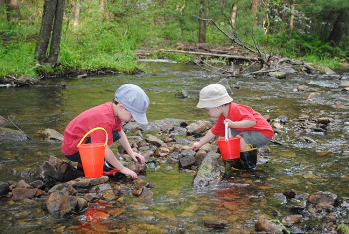
Our goal with the National Water Quality Initiative (NWQI) is to focus conservation and water quality monitoring and analyses where our efforts can have the most impact for clean water. We would like to see ag-impaired streams be de-listed, signifying that agricultural pollutants are no longer negatively impacting the stream.
How NWQI Works
The NWQI is a partnership among the Natural Resources Conservation Service (NRCS), state water quality agencies, and the US Environmental Protection Agency (EPA) to identify and address impaired water bodies through voluntary conservation. Conservation systems that avoid, control, and trap nutrients and sediments are crucial to keeping these pollutants out of our surface and ground water.
NWQI Offers
Targeted financial and technical support is available through NRCS. Outreach and educational efforts may be planned in your local watershed. Partnering agencies will likely be involved in outreach, planning, implementation, and especially water quality monitoring and analysis efforts.
Pennsylvania Priority Watersheds
NWQI has been in existence since 2012, but has now been extended through Fiscal Year 2023, with some updates including source water protection, watershed assessment plans, and a focus on water quality outcomes.
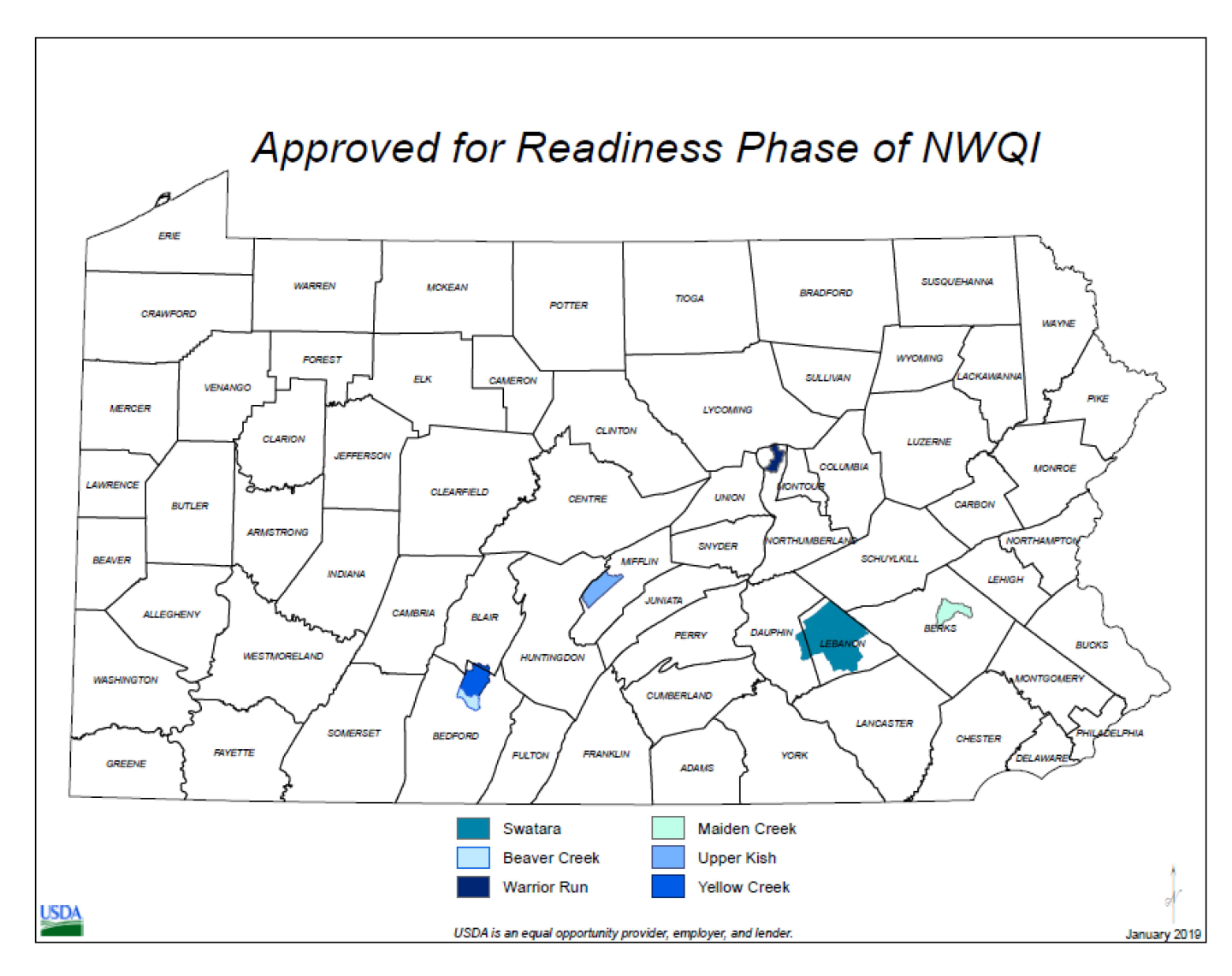
In 2019, the following watersheds were approved for the National Water Quality Initiative readiness phase.
- Warrior Run, Northumberland County
- Swatara Creek, Lebanon and Dauphin Counties
- Maiden Creek, Berks County
- Beaver and Upper Yellow Creeks, Bedford and Blair Counties
- Upper Kishacoquillas Creek, Mifflin County
See map above for the locations of these watersheds. These watersheds were selected due to agricultural impairment. During the readiness phase, Watershed Assessment Plans were developed. During this process, local stake holders and partners worked with NRCS to determine critical source areas for pollutants, output and outcome goals, outreach plans, ranking questions, cost estimates, and monitoring plans. Plans were developed for all watersheds and approved at a national level for internal use.
Several of the watersheds have been in the NWQI since 2012. Those are Maiden Creek, Beaver and Upper Yellow Creeks, and Upper Kishacoquillas Creek.
Swatara Creek and Maiden Creek are our source water protection pilot projects, meaning that they are focused on protecting water that will be used as a source of public drinking water. Nitrates and turbidity (sediment) are common concerns for drinking water. Preventing nitrate and sediment from exiting our farm land is important for drinking water quality, including clarity, taste, and toxicity. Removing excess amounts also makes the water less costly to treat to make it acceptable for human consumption.
Warrior Run
Warrior Run originates in Muncy Township, Lycoming County and flows south and west before emptying into the West Branch of the Susquehanna River just south of Watsontown. The entire basin includes 48.78 stream miles and drains 21.6 square miles. The land use is forest (mainly in the headwaters) and a mixture of agricultural and urban land. The Warrior Run basin (including all its tributaries) is currently listed as ag impaired. The critical source areas for the watershed are further prioritized within this watershed.
Swatara Creek
The Dauphin and Lebanon County potions of the Swatara Creek watershed included in the project encompass roughly 264 square miles and accounts for almost 60 percent of the entire Swatara Creek watershed. The watershed is composed of 8 HUC 12 watersheds: Middle Swatara Creek, Lower Swatara Creek, Lower Little Swatara Creek, Killinger Creek, Snitz Creek – Quitapahilla Creek, Reeds Creek – Swatara Creek, Bow Creek – Swatara Creek, and Manada Creek. Over 215 of the 350 miles of stream included in this project area designated as impaired due to agriculture. The critical source areas for the watershed are further prioritized within this watershed. Applications within the source water protection areas will receive additional ranking points in the competition with other applications for program funds.
Maiden Creek
The Maiden Creek watershed is the second largest tributary to the Schuylkill River and contains more than 100 miles of perennial streams. Lake Ontelaunee is a 1,082-acre manmade lake approximately six miles north of the city of Reading in Southeastern PA. Constructed in 1926, Lake Ontelaunee has the capacity to hold 3.88 billion gallons of water and has a 216 square mile drainage area known as the Maiden Creek Watershed. In addition, the reservoir contains a popular warm water fishery. Activities upstream of Lake Ontelaunee affect the drinking water of thousands of Reading residents.
The watershed includes seven HUC 12 watershed totaling 138,323 acres: Ontelaunee Creek Watershed, Eagle Point- Mill Creek Watershed, Saucony Creek Watershed, Willow Creek Watershed, Lower Maiden Creek Watershed, Upper Maiden Creek Watershed, and Pine Creek Watershed. Karst topography containing “pure limestone” is present in the watershed and can act as a conduit to groundwater. NWQI will focus on stopping the hydrologic transport of pollutants to the drinking water sources (surface and ground water). The critical source areas for the watershed are further prioritized within this watershed. Applications within the source water protection areas will receive additional ranking points in the competition with other applications for program funds.
Beaver and Upper Yellow Creek
Beaver Creek and Upper Yellow Creek are both in the Yellow Creek watershed in Bedford and Blair Counties. Yellow Creek is a tributary in the Juniata River watershed that eventually drains a highly productive agricultural valley locally known as “Morrison’s Cove” or simply “the Cove” into the Chesapeake Bay. This area has highly productive limestone soils and many highly productive dairy farms. It has had historical problems with high levels of nitrates in ground water along with sediment and nutrients in surface water. A Pennsylvania Department of Environmental Protection (DEP) study shows that every tributary in Beaver Creek and Upper Yellow Creek is impaired due to sediment and nutrients from agricultural sources. Yellow Creek itself is a top trout fishing stream and has also been classified by DEP as a Special Protection/High-Quality Steam. The critical source areas are further prioritized within this watershed.
Upper Kishacoquillas Creek
The Upper Kishacoquillas watershed or “Upper Kish” watershed is a coldwater fishery in Mifflin County that is part of the Chesapeake Bay watershed. Consisting of 58.6 miles of stream, the Upper Kish watershed drains approximately 19,064 acres or 30 square miles of Kishacoquilllas Valley, known locally as “Big Valley.” Agriculture (605), forested land (36 percent), developed land (approximately two percent), and transitional land (approximately two percent) compose the main land types in this watershed. It has been designated as an impaired watershed by DEP. The critical source areas for the watershed are further prioritized within this watershed.
How to Apply
To get started, make an appointment at your local office. If you are in the watershed, you can apply through NWQI. If not, you may be eligible for the Environmental Quality Incentives Program. For either, you will need to establish eligibility and farm records for your land. Then, NRCS will guide you in completing an application while explaining which conservation practices are available in your watershed.
For more information
Contact your local USDA-NRCS Service Center:
- Warrior Run - Northumberland County 570-415-3130
- Swatara Creek - Lebanon County 717-376-3513, Dauphin County 717-559-4020
- Maiden Creek - Berks County 484-512-3241, Lehigh County 484-635-3789 (Northampton County office)
- Beaver and Upper Yellow Creeks - Bedford County 484-512-3241, Blair County 814-317-3327
- Upper Kishacoquillas Creek - Mifflin County 717-953-3147
State Contact
Ashley Lenig
Conservation Program Manager
717-237-2204
Jared Shippey
Asst. State Conservationist for Programs
717-237-2216
Ready to get started?
Contact your local service center to start your application.
How to Get Assistance
Do you farm or ranch and want to make improvements to the land that you own or lease?
Natural Resources Conservation Service offers technical and financial assistance to help farmers, ranchers and forest landowners.

To get started with NRCS, we recommend you stop by your local NRCS field office. We’ll discuss your vision for your land.
NRCS provides landowners with free technical assistance, or advice, for their land. Common technical assistance includes: resource assessment, practice design and resource monitoring. Your conservation planner will help you determine if financial assistance is right for you.
We’ll walk you through the application process. To get started on applying for financial assistance, we’ll work with you:
- To fill out an AD 1026, which ensures a conservation plan is in place before lands with highly erodible soils are farmed. It also ensures that identified wetland areas are protected.
- To meet other eligibility certifications.
Once complete, we’ll work with you on the application, or CPA 1200.
Applications for most programs are accepted on a continuous basis, but they’re considered for funding in different ranking periods. Be sure to ask your local NRCS district conservationist about the deadline for the ranking period to ensure you turn in your application in time.
As part of the application process, we’ll check to see if you are eligible. To do this, you’ll need to bring:
- An official tax ID (Social Security number or an employer ID)
- A property deed or lease agreement to show you have control of the property; and
- A farm number.
If you don’t have a farm number, you can get one from USDA’s Farm Service Agency. Typically, the local FSA office is located in the same building as the local NRCS office. You only need a farm number if you’re interested in financial assistance.
NRCS will take a look at the applications and rank them according to local resource concerns, the amount of conservation benefits the work will provide and the needs of applicants. View Application Ranking Dates by State.
If you’re selected, you can choose whether to sign the contract for the work to be done.
Once you sign the contract, you’ll be provided standards and specifications for completing the practice or practices, and then you will have a specified amount of time to implement. Once the work is implemented and inspected, you’ll be paid the rate of compensation for the work if it meets NRCS standards and specifications.