
Idaho Current and Historical Conditions
About the Interactive Map (iMap)
View all current conditions and forecasts, in addition to the historical data, using the interactive map. This product shows data by basin or station, and includes access to site metadata, reports and time series plots. For pre-selected map links of current conditions, please see the links provided below.
NRCS Idaho Interactive Map Links
Snowpack
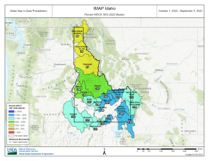
- Idaho Snow Water Equivalent Maps: Basin, SNOTEL Sites, Basin Monthly (includes Snow Courses), SNOTEL & Snow Courses Monthly
- Idaho Snow Depth Map: Current Season Total, 3-Day Change, 1-Day Change
- Western United States Snow Water Equivalent Maps: Basin & SNOTEL Sites
Precipitation
- Idaho Precipitation Maps: Basin Water Year Total, SNOTEL Sites Water Year Total, Basin Monthly, SNOTEL Sites Monthly
- Western United States Precipitation Maps: Water Year Total, Monthly Total
Reservoir Storage
- Idaho Reservoir Storage
- Western United States Reservoir Storage
- Bureau of Reclamation: Teacup Diagram, Reservoir Storage Dashboard
Additional Resources
- U.S. Drought Monitor: Current Map, Change Map, Conditions and Outlook
- NOAA NIDIS Conditions Dashboard: Idaho, National, Soil Moisture, Temperature & Precipitation
- UMRB Drought Indicators Dashboard
- NOAA Weather & Hazards Map
Data and Reports
Snow and Water Interactive Map
Welcome to the National Water and Climate Center's Snow and Water Interactive Map, a groundbreaking tool designed to provide farmers, researchers, policymakers, and water management professionals with up-to-the-minute snow survey data and water supply forecasting.
