

Wellsville-Mendon Watershed (Sponsor = Cache Water District)
The project is funded through authority of the Watershed Protection and Flood Prevention Act.
Notice of Intent to Prepare an Environmental Impact Statement
The Natural Resources Conservation Service (NRCS) Utah State Office, in cooperation with the U.S. Bureau of Reclamation (USBR), the Environmental Protection Agency (EPA), and Cache Water District (project sponsor), announces its intent to prepare a watershed plan for the Wellsville Canyon Watershed Plan located within the Little Bear River Watershed in Cache County, Utah. The proposed Wellsville Canyon Watershed Plan will examine alternative solutions to provide flood protection and conveyance infrastructure, reduce irrigation water loss, enhance recreational facilities, and reduce erosion and nutrient loading to the Little Bear River in Wellsville and Mendon cities and portions of unincorporated Cache County. NRCS is requesting comments to identify significant issues, potential alternatives, information, and analyses relevant to the proposed action from all interested individuals, Federal and State agencies, and Tribes.
NRCS began an Environmental Assessment (EA) for the proposed Project in mid-2021. As the EA developed, the project team completed public and agency scoping, development of the initial design alternatives and review of those alternatives based on the purpose and need for the project. Based on programmatic project scale requirements, NRCS determined an EIS was necessary and is seeking further public comment to help determine the range of actions, alternatives, and impacts to be evaluated and included in the EIS. Written or emailed comments can be submitted through June 7, 2024, and should be directed to:
Mail: Wellsville Canyon Watershed Plan-EIS
c/o Landon Richins
1276 South 820 East, Suite 100
American Fork, Utah 84003
Email: wellsvillecanyoneis@fransoncivil.com
Please note that all comments received previously during the Environmental Assessment scoping comment period in 2021 will be included and do not need to be resubmitted. Previous comments submitted can be reviewed in the Scoping Report at the bottom of this page. Water resource concerns and alternatives previously identified in the EA are shown below.
Following the public comment period, the planning process will continue to move forward with development of alternatives and the alternative analysis required for the EIS. The Draft EIS is anticipated to be available Summer 2024, which will include another public comment period.
Purposes and Project Objectives
The primary purposes and objectives for watershed planning and preparation of this EIS are to:
- Provide flood control to the Cities of Wellsville, Mendon, and portions of unincorporated Cache County from flooding that occurs from large thunderstorms and rain on frozen ground events in the valley.
- Provide more reliable management of agricultural water in the area by constructing a more efficient irrigation delivery system to mitigate current seepage losses; and
- Enhance recreational opportunities within the project area.
Watershed planning is authorized under Public Law 83–566, the Watershed Protection and Flood Prevention Act of 1954, as amended, and Public Law 78–534, the Flood Control Act of 1944.
Project Need―Current Resource Concerns
Flood Protection
- Inadequate flood capacity through Wellsville, Mendon, and areas of unincorporated Cache County
- Address historic flooding of homes and roads
- Reduce erosion and nutrient loading to the Little Bear River
The project will reduce flood risks and improve public safety in the watershed. Furthermore, it will greatly reduce flooding concerns associated with intense rain-on-snow and/or frozen ground events within the project area. More dependable floodwater management will benefit homes, businesses, agricultural fields, roads, and public utilities in the area.
Agricultural Water Management
- Improve water management and measurement
- Reduce demand on the culinary water systems
- Reduce seepage loss in existing earthen conveyance systems
The project will implement improved culinary and agricultural water conservation techniques in the watershed. A more efficient irrigation delivery system within Mendon City and Wellsville City will help mitigate the heavy seepage losses experienced by the current earthen canal irrigation distribution systems. The project improvements will also reduce demand for the existing culinary water systems within the watershed and capital expenditures to meet peak summer irrigation demands.
Recreation
The project will address limited public recreational facilities and opportunities within the watershed available for the growing population of Cache County. Recreational improvements will provide residents with a higher quality of life and will increase the public’s well-being by providing new opportunities for leisure and enjoyment.
Preliminary Proposed Action and Alternatives
The watershed-focused planning area is approximately 70,845 acres. NRCS will evaluate a minimum of two action alternatives and the no action alternative in the Draft EIS. NRCS will provide technical and financial assistance for the proposed project through the NRCS Watershed Protection and Flood Prevention Program, and NRCS will also design and implement a selected alternative. Possible alternatives are:
Alternative 1—No Action Alternative. Taking no action would consist of activities carried out if no federal action or funding were provided. This alternative would not address flooding into the canals. The canals would continue to overtop during rain-on-snow events, and flooding in the project area would continue. The canals would be maintained in their existing condition as earthen channels, and irrigation conveyance within the communities of Wellsville and Mendon would continue unchanged. The additional recreational access to Wellsville Reservoir would not be built. Additionally, erosion and sedimentation from the alluvial plains above the canals would continue unaltered under this alternative. The existing project infrastructure would continue to operate in its current condition and would not improve flood control, conserve irrigation water, improve recreational access, or reduce watershed erosion as described above. Residents would continue to use culinary water for irrigation (i.e., watering lawns and gardens), putting stress on existing water supply and infrastructure.
Alternative 2—Proposed Action. The proposed action is to enclose the Wellsville-Mendon Canal (Lower Canal) and convey water through piping in Wellsville and Mendon cities and part of unincorporated Cache County, Utah. The existing Wellsville-Mendon Canal would be improved with the addition of open channel overflow systems at 2900 South or 3400 South (Unincorporated Cache County) and 200 South (Mendon City). This would be accomplished through a combination of conduits and channels to convey floodwaters from the west side of Cache Valley between Wellsville and Petersboro to the natural floodplain of the Little Bear River east of the communities. This proposed action would continue to divert the water for the Wellsville-Mendon Conservation District from below Hyrum Reservoir at the existing diversion points. This proposed action would also enclose and pipe a portion of the Wellsville Eastfield Canal beginning at the existing diversion at the base of Hyrum Dam and passing through Hyrum and ending in unincorporated Cache County, Utah. This proposed action would also pressurize Wellsville City Irrigation Company’s irrigation system within Wellsville City and within Mendon City’s irrigation system managed by the Mendon North, Mendon Central, Mendon South, Mendon Second North, and Greater Mendon Irrigation companies. This proposed action would also install regulating ponds to stabilize peak demands on the pressurized irrigation systems. A new access ramp limited to non-motorized personal watercraft would be constructed at Wellsville Reservoir for recreational activities. Additionally, a reflecting pond may be constructed as an additional recreation component near Mendon cemetery.
Alternative 3—Lining Alternative. All project measures would be the same as Alternative 2 with the following exceptions. Alternative 3 would line and increase the capacity of the Wellsville-Mendon Canal (Lower Canal) to carry both irrigation and flood water from the west alluvial plains between Wellsville and Petersboro in Cache County instead of enclosing and piping. This would include the reconstruction of the existing Murray Spring overflow structure and the addition of overflow structures at 2900 South or 3400 South in unincorporated Cache County and 200 South in Mendon City.
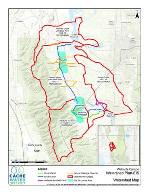
Project Watershed Map
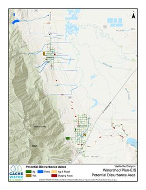
Potential Disturbance Areas Map
Additional Documents
Contact Information
Landon Richins —Franson Civil Engineers
1276 South 820 East, Suite 100
American Fork, Utah 84003
Phone: 801-756-0309
Email: wellsvillecanyoneis@fransoncivil.com
Derek Hamilton —USDA-NRCS
125 S. State Street, Room 4010
Salt Lake City, UT 84138-1100
Phone: 801-524-4560
Email: derek.hamilton@usda.gov