
NRCS is partnering with the Warren Land Conservation Trust, Save the Bay, and the Rhode Island Department of Environmental Management's (RIDEM) Mosquito Abatement Program to restore salt marshes, freshwater wetlands and coastal buffers on the eastern side of the Palmer River in Warren, RI.
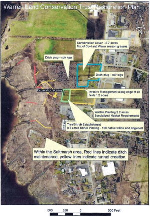
NRCS worked with the original property owner in November 2020 to protect 24 acres of degraded salt marsh and farmland with a Wetland Reserve Easement. The property owner then donated the land to the Warren Land Conservation Trust, which owned an adjacent parcel. The two parcels being restored total 25.35 acres –22.85 acres of wetlands and 2.5 acres of upland (right).
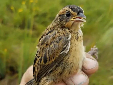
Project partners had been trying to preserve the undeveloped land for conservation since 2015 because it has area to allow salt marsh to migrate into the freshwater wetlands and undeveloped upland under future sea level rise scenarios. The site also has potential to become high quality saltmarsh sparrow (Ammospiza caudacuta) habitat.
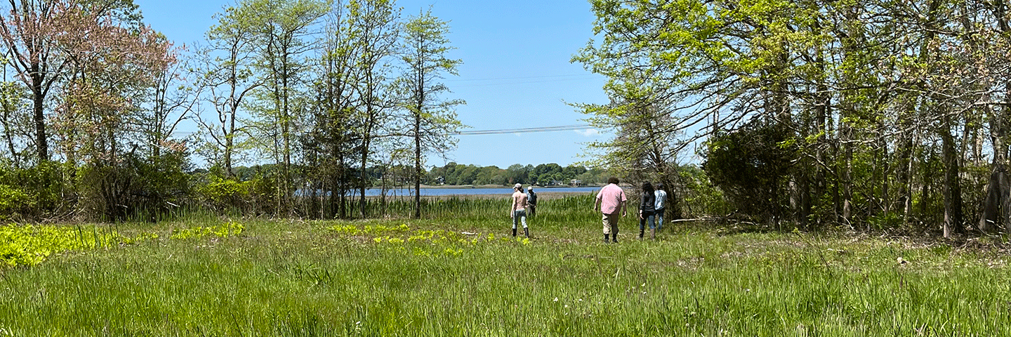
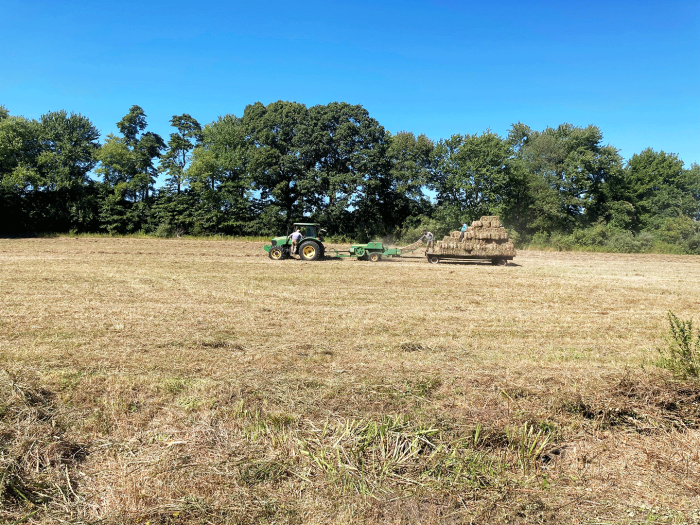
The project should take about four years to complete and provide multiple ecological benefits for water quality, wildlife and habitat. Restoration activities are taking place on abandoned agricultural fields, a freshwater/ brackish wetland adjacent to the marsh, upland buffer, and salt marsh. Through the project, partners are mowing brush, clearing invasive plants, removing dead trees, seeding pollinator plants and planting native trees.
In the salt marsh, partners are excavating shallow channels (or runnels) through the marsh to restore healthy flows of salt and fresh water between the marsh, wetlands and upland. The runnels will lower the water level in impounded areas on the marsh platform and tie into selected existing ditches that are clogged with vegetation, which will be periodically cleaned to facilitate drainage of the marsh platform.
Download the Sowam's Meadow Wetland Reserve Easement Restoration Plan from the Warren Land Conservation Trust website.
Restoration Progress
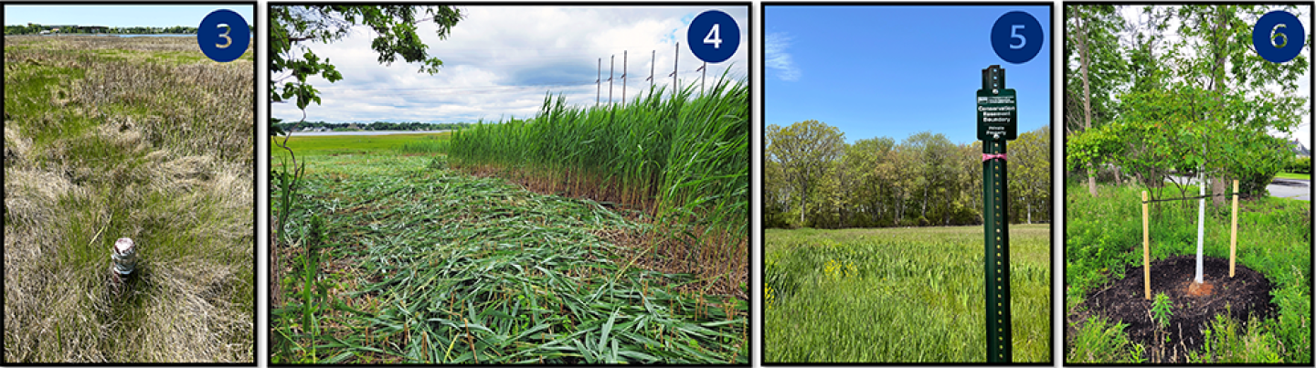
Save the Bay staff set up photo stations, monitoring wells ❸, and vegetation monitoring transects in the salt marsh and marsh migration corridor and interns and Warren Land Conservation Trust volunteers conducted pre-restoration vegetation monitoring in Fall 2021.
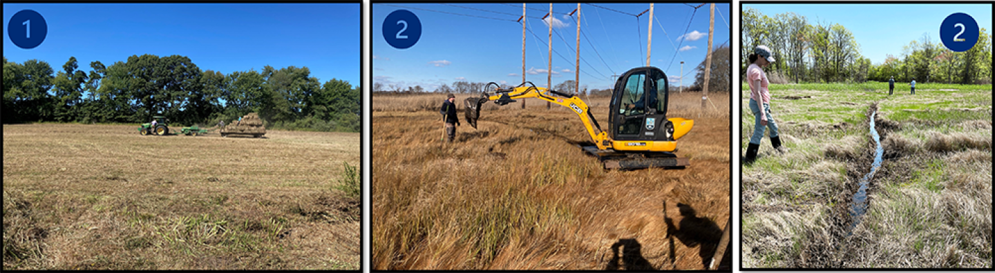
In 2022, project partners have secured relevant permits, installed the project sign, and removed old fence posts. In Fall 2022, partners mowed existing fields and removed invasive trees and vines from field borders. The work was done by crews from Staton’s Landscaping in Warren under contract with NRCS. Partners also dug runnels through the marsh with RIDEM’s Low Pressure Excavator (named Victoria due to her British roots).
- Jan. & June 2023: Cut-back of invasive exotic species, Phragmites australis ❹.
- Fall 2023: Native tree planting around field perimeter ❻.
- Jan. 2024: Pollinator seed mix and conservation cover (cool/warm season grasses) planted.
Saltmarsh Sparrow Initiative
Saltmarsh sparrows (Ammospiza caudacuta) breed in salt marshes in all coastal New England states including Rhode Island. Their populations are declining due to loss of high marsh habitat where they nest due to sea level rise and past human impacts. Nest flooding is the main driver of population declines.
The Saltmarsh Sparrow Conservation Plan includes strategies to improve the resiliency of existing salt marshes and facilitate marsh migration. By restoring marsh tidal hydrology, partners aim improve habitat conditions for saltmarsh sparrows by restoring high marsh habitat.
Background
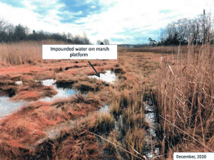
The Palmer River salt marsh was showing signs of degradation — standing water on the marsh platform, stunted vegetation, vegetation die-off and marsh platform subsidence (see photo at right). Marshes lose surface elevation from persistent waterlogging, which causes a series of cascading processes: reduced plant growth > vegetation die off > root decomposition that creates voids in the root zone > collapse and further surface subsidence of the marsh platform. Salt marsh ecologists refer to this process as waterlogged subsidence trajectory.
Similar conditions have been documented throughout the Narragansett Bay watershed and southeastern New England. Increased water impoundment on marsh platforms is due in part to accelerated sea level rise and legacy human impacts. Based on regional data from the Narragansett Bay Estuarine Research Reserve, salt marshes are not building enough elevation to keep pace with the accelerated rate of relative sea level rise in Narragansett Bay (5.2 mm/year). Human impacts include agricultural and mosquito ditching, linear ditch spoils, agricultural berms built to hay the marsh, and stone walls. Berms were built in the 18th and 19th centuries to reduce or eliminate tidal waters from the area to grow hay.
Impacts to Sowam's salt marshes from sea level rise and past human activities include vegetation conversion from high marsh species to stunted, low marsh species (Spartina alterniflora or cordgrass); vegetation die-back; expansion of impounded water on the marsh platform; algal mats in the impounded water; and peat subsidence. Without healthy plants to trap sediment and increase marsh surface elevation through accumulation of below-ground biomass, the marsh surface has subsided and converted to shallow impounded water that do not support fish and create mosquito breeding habitat.
Marsh vegetation can recover if impounded water is drained off the marsh platform by excavating shallow runnels and selectively maintaining some of the old mosquito ditches. Revegetation helps stabilize the peat by allowing below-ground biomass to accumulate, and results in higher densities of aboveground stems that trap sediment.
Runnels are small, human-made channels that drain impounded water from the marsh platform. Unlike ditches, they are shallow and only extend up to 12 inches deep. Runnels allow vegetation to recolonize die-off areas by reducing root zone saturation and optimizing hydrologic connectivity between standing water on the marsh and adjacent natural creeks or ditches. The ditches that the runnels drain into may require selective cleaning to facilitate drainage of the marsh platform. Only a few of these ditches will be cleared, and they will not be restored to their original size so that the marsh is not excessively drained.
The freshwater wetland and low lying upland adjacent to the salt marsh will be restored with native plants to facilitate future salt marsh migration (protected marsh migration corridor, at right). There is already evidence along the upper edge of the marsh of migration through die-off of upland vegetation and conversion to more salt tolerant species.
Project Description
Project goals:
- To convert fields to native grasses to allow salt marsh migration under future sea level rise scenarios,
- To remove barriers along the upper edges of the salt marsh to allow salt water to flow into upland areas,
- To restore a freshwater wetland community in a portion of the existing hay fields
- To establish pollinator and native grass seedings within the other portion of the field, and
- To restore salt marsh sparrow habitat.
The project’s Restoration Site Plan highlights the location of the runnels to be installed through the ditch spoils and agricultural berms, the clogged ditches that will be maintained, and the area where invasive plants will be removed and native grasses, shrubs and pollinator species will be planted bordering the freshwater wetland and coastal buffer.
To develop the site plan, Save The Bay, NRCS and Warren Land Conservation Trust staff conducted multiple site visits and analyzed historic and recent aerial photography to determine the location of the runnels to be installed, the ditches to be maintained, the area of Phragmites australis to mulch, and the planting and invasive removal plan for the freshwater wetland and upland buffer. Plans were reviewed by RlDEM's Mosquito Abatement program.
Salt marsh restoration
The Salt Marsh Restoration Plan includes excavating runnels through existing agricultural berms, maintaining a select number of existing ditches, and mulching 1.3 acres of Phragmites australis (right).
Freshwater wetland and marsh migration facilitation
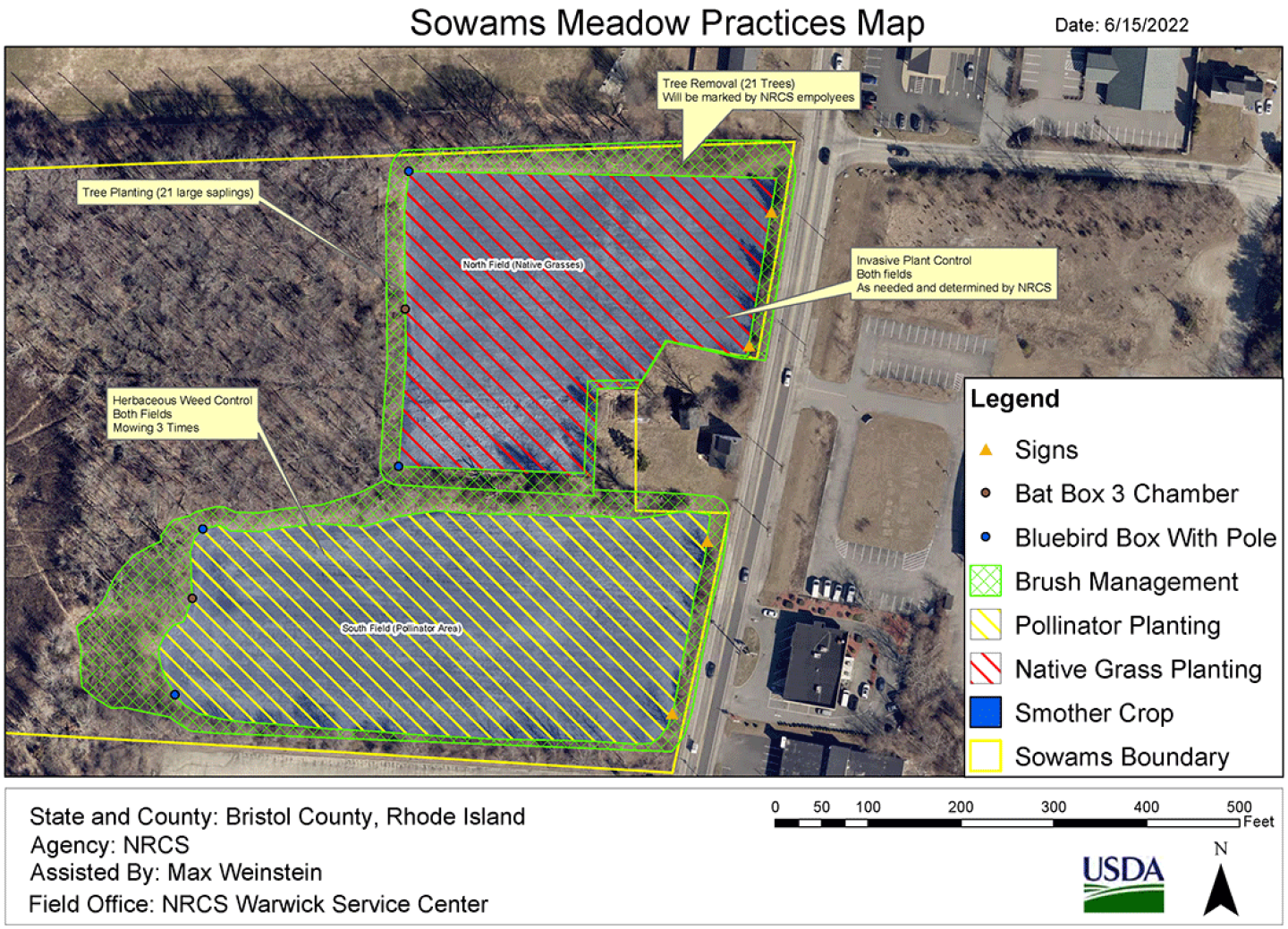
Three NRCS-designed seeding/planting methods will be used on about 4.1 acres of degraded agricultural wetlands to establish a high-value, diverse habitat mosaic for targeted wildlife species:
- About 2.7 acres of conservation cover (warm/cool-season grass mix) will be planted at the highest elevation in the northern field.
- About 2.2 acres of pollinator seed mix will be planted at lower elevation in the southern field to will maximize benefits to pollinators and the monarch butterfly.
- Woody invasive plants [Rosa multiflora, honeysuckle (Lonicera sp.), autumn olive, (Elaeagnus umbellate), buckthom, (Rhamnus sp.) and bittersweet (Celastrus orbiculatus)] in a 1.2-acre area bordering the fields will be removed by mechanical cutting and herbicidal stump treatment with no broadcast spraying. Cutting and treatment of invasive vegetation will occur in August/ September when plants will actively pull the herbicide down into the roots.
Monitoring
Save The Bay staff established photo stations and vegetation monitoring transects in the salt marsh and marsh migration corridor. Save The Bay interns and Warren Land Conservation Trust volunteers conducted pre-restoration vegetation monitoring in late summer/ fall 2021 and will monitor post restoration for two years. The monitoring program will provide data both for evaluating whether the project goals are met and to compare results with other runnel projects in the region.
Maintenance and Adaptive Management
Save The Bay and the Warren Land Conservation Trust, in partnership with RIDEM, will maintain the runnels by hand to ensure they are providing the necessary drainage. Maintenance will include clearing out any sediment, wrack or macroalgae. Project partners requested a 10-year permit to allow for runnel and ditch maintenance and management of invasive plants in the restored pollinator and grassland habitat.
Invasive plants along the edge of the field will be managed by the Warren Land Conservation Trust in consultation with NRCS. The area will be periodically scouted and re-treated when necessary. WLCT/NRCS will also collaborate to manage the pollinator meadow and native grass habitat. Once established, these areas will be mowed as little as possible. As per NRCS wildlife/pollinator management recommendations, the fields will be mowed every other year. This management approach produces vertical diversity of the vegetation which is associated with higher species richness of both vertebrate and invertebrate species.
Additional Information
Wetland Reserve Easements - Rhode Island
NRCS in Rhode Island is now accepting applications for ACEP Wetlands Reserve Easements (WRE). Applications that meet eligibility and ranking criteria in ACEP-WRE targeted areas received by Dec. 20, 2024, will be considered for our second round of FY 2025 funding.
Learn More