
HOSMER SERIES
LOCATION IN+IL KY
Established Series
Rev. SWN-BGN
03/2011
The Hosmer series consists of very deep, moderately well drained soils formed in loess on hills. They are moderately deep to a fragipan. Slopes are commonly 2 to 12 percent, but range from 0 to 30 percent. Mean annual precipitation is about 1068 mm (42 inches) and mean annual temperature is about 14 degrees C (57 degrees F).
TAXONOMIC CLASS: Fine-silty, mixed, active, mesic Oxyaquic Fragiudalfs
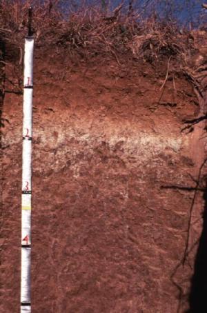
TYPICAL PEDON: Hosmer silt loam on a 4 percent convex west-facing slope in a cultivated field at an elevation of about 158 meters (520 feet) above mean sea level (MSL). (Colors are for moist soil unless otherwise stated.)
Ap--0 to 15 cm (0 to 6 inches); brown (10YR 4/3) silt loam; weak medium granular structure; friable; many fine roots; neutral; abrupt smooth boundary. [15 to 25 cm (6 to 10 inches) thick]
BE--15 to 33 cm (6 to 13 inches); yellowish brown (10YR 5/4) silt loam; weak fine subangular blocky structure; friable; common fine roots; moderately acid; clear smooth boundary. [0 to 25 cm (0 to 10 inches) thick]
Bt1--33 to 53 cm (13 to 21 inches); yellowish brown (10YR 5/6) silty clay loam; moderate medium subangular blocky structure; firm; common fine roots; many distinct brown (7.5YR 4/4) clay films on faces of peds; many distinct pale brown (10YR 6/3) clay depletions on faces of peds; very strongly acid; clear smooth boundary.
Bt2--53 to 71 cm (21 to 28 inches); yellowish brown (10YR 5/6) silty clay loam; weak medium prismatic structure parting to moderate medium subangular blocky; firm; common fine roots; many distinct brown (7.5YR 4/4) clay films on faces of peds; many distinct pale brown (10YR 6/3) and common light brownish gray (10YR 6/2) clay depletions on vertical faces of peds; few fine prominent black (10YR 2/1) manganese coatings on faces of peds; very strongly acid; clear wavy boundary. [Combined thickness of the Bt horizons is 30 to 66 cm (12 to 26 inches.)]
Btx/E--71 to 76 cm (28 to 30 inches); yellowish brown (10YR 5/6) silt loam (Btx); weak coarse prismatic structure parting to moderate medium subangular blocky; firm; few fine roots; many fine vesicular pores; many distinct and prominent light brownish gray (10YR 6/2) and light gray (10YR 7/1) clay depletions on faces of peds and filling voids comprising 10 to 15 percent of the horizon by volume (E); very strongly acid; abrupt irregular boundary. [0 to 10 cm (0 to 4 inches) thick]
Btx1--76 to 114 cm (30 to 45 inches); yellowish brown (10YR 5/6) silt loam; strong very coarse prismatic structure; very firm; few fine flattened roots between peds; many distinct brown (7.5YR 4/4) clay films on faces of peds; many distinct light brownish gray (10YR 6/2) clay depletions in pores and on faces of peds; brittle; very strongly acid; gradual wavy boundary.
Btx2--114 to 163 cm (45 to 64 inches); yellowish brown (10YR 5/6) silt loam; strong very coarse prismatic structure; very firm; many fine vesicular pores; few distinct brown (7.5YR 4/4) clay films on faces of peds; common distinct light brownish gray (10YR 6/2) clay depletions on faces of peds; brittle; very strongly acid; gradual irregular boundary. [Combined thickness of the Btx horizons is 61 to 127 cm (24 to 50 inches.)]
2Bt--163 to 203 cm (64 to 80 inches); yellowish brown (10YR 5/4) silt loam; weak very coarse prismatic structure; friable; few discontinuous distinct gray (10YR 5/1) clay films on faces of peds; common distinct light brownish gray (10YR 6/2) clay depletions on faces of peds; 15 percent fine and medium sand; strongly acid.
TYPE LOCATION: Knox County, Indiana; about 1.5 miles northeast of Frichton; 1,340 feet east and 435 feet south of the northwest corner of donation 68, T. 3 N., R. 9 W.; USGS Frichton, IN-IL topographic quadrangle, lat. 38 degrees 41 minutes 54.169 seconds N., 087 degrees 24 minutes 01.064 seconds W., UTM Zone 16, 465186 easting and 4283384 northing, NAD 83.
RANGE IN CHARACTERISTICS:
Depth to the base of the argillic horizon: 127 to more than 203 cm (50 to more than 80 inches)
Depth to the fragipan: 51 to 91 cm (20 to 36 inches)
The particle-size control section averages: 22 to 30 percent clay and 2 to 10 percent sand
Ap horizon:
Hue: 10YR
Value: 4 or 5
Chroma: 2 to 4
Texture: commonly silt loam, except some severely eroded pedons are silty clay loam
Reaction: strongly acid in non-limed areas, and ranges to neutral in limed areas
E horizon, where present:
Hue: 10YR
Value: 4 or 5
Chroma: 2 to 6
Reaction: moderately acid to very strongly acid
Bt and BE horizons:
Hue: 10YR or 7.5YR
Value: 4 to 6
Chroma: 3 to 6
Texture: silt loam or silty clay loam
Reaction: strongly acid or very strongly acid in non-limed areas, and ranges to moderately acid in limed areas
Btx horizon:
Hue: 10YR or 7.5YR
Value: 4 to 6
Chroma: 3 to 8 with redox depletions
Reaction: commonly strongly acid or very strongly acid, and less commonly moderately acid
2Bt, B't, BC, and C horizons, where present:
Hue: 10YR or 7.5YR
Value: 4 to 6
Chroma: 3 to 8
Texture: silt loam or silty clay loam
Reaction: moderately acid to very strongly acid.
COMPETING SERIES:
Apalona, Ava, Bedford, Cincinnati, Fountainville, Grantsburg, Hildebrecht, Nicholson, Omulga, Otwell, Otwood, Solsberry, Weisburg, and Zanesville series. Apalona, Bedford, Nicholson and Weisburg soils average more than 28 percent clay in the lower part of the series control section. Ava, Cincinnati and Solsberry soils have rock fragments in the middle or lower part of the series control section. Fountainville soils have a lithic contact at depths of 102 to 152 cm (40 to 60 inches). Grantsburg soils have a lower base saturation in the series control section. Lawrenceville and Zanesville soils have a lithic contact in the series control section. Omulga and Otwell soils have average more than 28 percent clay in some subhorizon within the lower part of the series control section. Sadler soils have a glossic horizon in the series control section.
GEOGRAPHIC SETTING: Hosmer soils are commonly on summits, shoulders, and backslopes of loess hills. Hosmer soils formed in either silty loess, or silty loess and the underlying "gritty" loess which has a higher sand content. The slope gradient is commonly 2 to 12 percent, but ranges from 0 to 30 percent.
The mean annual precipitation ranges from 889 to 1168 mm (35 to 46 inches). The mean annual temperature ranges from 11 to 14 degrees C (51 to 57 degrees F). Frost-free period ranges from 170 to 210 days. Elevation ranges from 104 to 311 meters (340 to 1020 feet) above sea level.
GEOGRAPHICALLY ASSOCIATED SOILS:
Alford, Iva, Muren, Stoy and Weir soils. The well drained Alford soils are on summits, shoulders, and backslopes of loess hills. The somewhat poorly drained Iva soils are on nearly level flats. The moderately well drained, more permeable Muren soils are on summits and shoulders. The somewhat poorly drained Stoy soils are on nearly level to gently rolling summits. The poorly drained Weir soils are on flats.
DRAINAGE AND SATURATED HYDRAULIC CONDUCTIVITY: Moderately well drained. A perched, seasonal water table is at a depth of 46 to 76 centimeters (1.5 to 2.5 feet) from December through April in most years. Saturated hydraulic conductivity is moderately high or high (4.23 to 14.11 micrometers/sec) above the fragipan and low to moderately high (0.07 to 1.41 micrometers/sec) in and below the fragipan. Permeability is moderate (0.6 to 2.0 inches per hour) above the fragipan and slow or very slow in and below the fragipan. The potential for surface water runoff is medium to very high.
USE AND VEGETATION: Most areas are used for growing corn, soybeans, winter wheat, or used for hay. Some areas are used for pasture and woodland. Native vegetation is mixed, deciduous hardwood forest.
DISTRIBUTION AND EXTENT: Southern Indiana, southern Illinois and western Kentucky. The acreage is of large extent and is in MLRAs 113, 114B, 115A, 120A and 120B. The type location is in MLRA 115A.
MLRA SOIL SURVEY REGIONAL OFFICE (MO) RESPONSIBLE: Indianapolis, Indiana
SERIES ESTABLISHED: Vanderburgh County, Indiana, 1939.
REMARKS: Diagnostic surface, subsurface horizons and features recognized in this pedon are: 1) Ochric epipedon: the zone from 0 to 15 cm (0 to 6 inches) (Ap horizon); 2) Argillic horizon: the zone from 15 to 203 cm (6 to 80 inches) (Bt1, Bt2, Btx/E, Btx1, Btx2, 2Bt horizons); 3) Fragipan: the zone from76 to 163 cm (30 to 64 inches) (Btx1, Btx2 horizons); 4) Redoximorphic features: from 53 to 203 cm (21 to 80 inches).
ADDITIONAL DATA: Characterization data from the Agricultural Experiment Station, Purdue University is on file for several pedons from Indiana.
National Cooperative Soil Survey
U.S.A.