
DEL REY SERIES
LOCATION IL+IN MI OH WI
Established Series
Rev. GOW-JWS-RAR
05/2008
The Del Rey series consists of very deep, somewhat poorly drained, formed in lacustrine materials on lake plains. Slopes range from 0 to 7 percent. Mean annual precipitation is about 889 millimeters (35 inches), and mean annual temperature is about 11 degrees C (51 degrees F).
TAXONOMIC CLASS: Fine, illitic, mesic Aeric Epiaqualfs
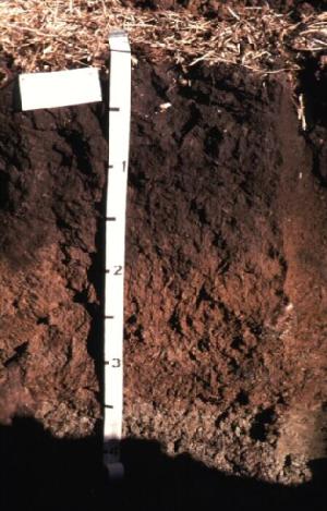
TYPICAL PEDON: Del Rey silt loam - on a west-facing slope of less than 1 percent under mixed grasses and scattered trees at an elevation of 202 meters (663 feet) above mean sea level. (Colors are for moist soil unless otherwise stated.)
A--0 to 10 centimeters (0 to 4 inches); dark grayish brown (10YR 4/2) silt loam, light brownish gray (10YR 6/2) dry; moderate fine and medium granular structure; friable; many fine roots; neutral; abrupt smooth boundary. (5 to 15 centimeters or 2 to 6 inches thick)
E--10 to 23 centimeters (4 to 9 inches); light brownish gray (10YR 6/2) silt loam; light gray (10YR 7/2) dry; moderate thin and medium platy structure; friable; many fine roots; moderately acid; abrupt smooth boundary. (0 to 20 centimeters or 0 to 8 inches thick)
Bt--23 to 30 centimeters (9 to 12 inches); brown (10YR 5/3) silty clay loam; strong fine subangular blocky structure; firm; common fine roots; many distinct grayish brown (10YR 5/2) clay films on faces of peds and many distinct pale brown (10YR 6/3) (dry), clay depletions on faces of peds; very strongly acid; clear smooth boundary.
Btg1--30 to 64 centimeters (12 to 25 inches); light brownish gray (2.5Y 6/2) silty clay; strong fine and medium subangular blocky structure; firm; common fine roots; many distinct grayish brown (10YR 5/2) clay films on faces of peds; few fine prominent yellowish brown (10YR 5/8) masses of oxidized iron in the matrix; very strongly acid; clear smooth boundary.
Btg2--64 to 84 centimeters (25 to 33 inches); 50 percent light brownish gray (2.5Y 6/2), 30 percent light olive brown (2.5Y 5/4) and 20 percent gray (10YR 6/1) silty clay; moderate fine and medium angular and subangular blocky structure; firm; common fine roots; many distinct grayish brown (2.5Y 5/2) clay films on faces of peds; strongly acid; gradual smooth boundary. (The combined thickness of the Bt horizon is 38 to 94 centimeters or 15 to 37 inches.)
BCtg--84 to 104 centimeters (33 to 41 inches); 35 percent light brownish gray (2.5Y 6/2), 35 percent gray (10YR 6/1) and 30 percent light olive brown (2.5Y 5/4) silty clay loam; weak coarse angular and subangular blocky structure; firm; few fine roots; common faint grayish brown (2.5Y 5/2) clay films on vertical faces of peds; slightly alkaline; gradual smooth boundary. (0 to 33 centimeters or 0 to 13 inches thick)
Cg--104 to 152 centimeters (41 to 60 inches); 55 percent grayish brown (10YR 5/2), and 45 percent yellowish brown (10YR 5/6 and 5/8) silty clay loam; massive; friable; few distinct light gray (10YR 7/1) (dry), clay depletions on bedding planes; strongly effervescent; moderately alkaline.
TYPE LOCATION: Iroquois County, Illinois; about 9 kilometers (5.5 miles) northeast of Buckley, 47 meters (155 feet) south and 274 meters (900 feet) west of the northeast corner of sec. 1, T. 25 N., R. 11 E., USGS Onarga West topographic quadrangle; lat. 40 degrees 40 minutes 43 seconds N., and long. 88 degrees 00 minutes 13 seconds W., NAD27; UTM Zone 16, 0415182 easting and 4503569 northing, NAD 83.
RANGE IN CHARACTERISTICS: The depth to the base of soil development typically is 61 to 122 centimeters (24 to 48 inches). The particle-size control section averages between 35 and 45 percent clay.
The Ap or A horizon has hue of 10YR, value of 3 or 4, and chroma of 1 to 3. It is silt loam, silty clay loam, or loam. Reaction ranges from very strongly acid to neutral.
The E or Eg horizon has hue of 10YR, value of 4 to 6, and chroma of 1 to 3. It is silt loam. Reaction ranges from very strongly acid to neutral. Some pedons have a EB or BE horizon with properties similar to the E horizon.
The Bt or Btg horizon has hue of 10YR, 2.5Y, or 5Y; value of 4 to 6; and chroma of 1 to 6. It is silty clay loam or silty clay. Reaction ranges from very strongly acid to slightly alkaline.
The BC, BCg, BCt, or BCtg horizon has hue of 10YR, 2.5Y, or 5Y; value of 4 to 6; and chroma of 1 to 8. Texture is silty clay loam or silty clay. The lower part of the horizon is stratified in some pedons and some strata are silt loam. Reaction is slightly alkaline or moderately alkaline. The horizon is calcareous in some pedons.
The Cg or C horizon has hue of 10YR, 2.5Y, or 5Y; value of 4 to 6; and chroma of 1 to 8. It commonly is silt loam or silty clay loam several feet thick. Some pedons are stratified with layers of silt loam, silty clay loam, clay loam, sandy loam, sand, and silty clay. Average clay content ranges from 22 to 33 percent. Average sand content ranges from 5 to 20 percent. Rock fragment content is less than 2 percent. Reaction is slightly alkaline or moderately alkaline.
COMPETING SERIES: These are the Bennington, Blount, Fulton, Kimmell, Mahoning, and Nappanee, soils. The Bennington and Mahoning soils have more than 2 percent rock fragments in the lower part of the series control section. The Blount and Kimmell soils have a densic contact in the lower part of the series control section. The Fulton soils average more than 33 percent clay in the lower part of the series control section. Nappanee soils average more than 45 percent clay in the particle-size control section.
GEOGRAPHIC SETTING: Del Rey soils are on lake plains of Wisconsinan age. Slope gradients range from 0 to 7 percent. The soils formed in calcareous silt loam or silty clay loam lacustrine sediments. Some pedons have clay loam till in the substratum below depths of 112 centimeters (44 inches). Mean annual temperature ranges from about 7 to 13 degrees C (45 to 55 degrees F), and mean annual precipitation ranges from about 737 to 1,016 millimeters (29 to 40 inches). Growing season ranges from 140 to 180 days.
GEOGRAPHICALLY ASSOCIATED SOILS:
Aptakisic, Camden, Martinton, Milford, Nappanee, Saylesville, Starks, and Zurich soils. Aptakisic, Martinton Nappanee, and Starks soils are on nearby similar positions. Aptakisic and Starks soils contain less clay. Martinton soils have mollic epipedons. The Camden, Saylesville, and Zurich soils are better drained, contain less clay in the control section, and are on higher landform positions. The poorly drained and very poorly drained Milford soils are on nearby nearly level or depressional parts of glacial lake plains and have a mollic epipedon.
DRAINAGE AND SATURATED HYDRAULIC CONDUCTIVITY: Somewhat poorly drained. The perched seasonal high water table is at a depth of 15 to 61 centimeters (0.5 to 2.0 feet) below the surface during January and May in most years. The potential for surface runoff is negligible to very high. Saturated hydraulic conductivity is moderately low to moderately high (0.42 to 1.41 micrometers per second). Permeability is slow.
USE AND VEGETATION: Many areas of this soil are used to grow crops. Corn, soybeans, and small grain are the principal crops. Other areas are used for pasture. Native vegetation is hardwood forest.
DISTRIBUTION AND EXTENT: MLRAs 95B, 98, 99, 110, and 111. Northeastern Illinois and in southern Wisconsin, northern Indiana, southern Michigan, and northern Ohio. This soil is extensive, with over 80,937 hectares (200,000 acres).
MLRA SOIL SURVEY REGIONAL OFFICE (MO) RESPONSIBLE: Indianapolis, Indiana
SERIES ESTABLISHED: Iroquois County, Illinois, 1940.
REMARKS: A till substratum phase with clay loam till below a depth of 112 centimeters (44 inches), and a sandy substratum phase with sandy sediments below a depth of 102 centimeters (40 inches) have been recognized. These soils will be evaluated during MLRA update activities.
Diagnostic horizons and features recognized in this pedon are: ochric epipedon - the zone from the surface of the soil to a depth of about 23 centimeters (9 inches) (A and E horizons); albic horizon - the zone from a depth of 10 to 23 centimeters (4 to 9 inches) (E horizon); argillic horizon - the zone from approximately 23 to 84 centimeters (9 to 33 inches) (Bt, Btg1, and Btg2 horizons); aquic conditions - presence of redoximorphic features in the zone from 23 to 152 centimeters (9 to 60 inches) (E, Bt, Btg1, Btg2, BCtg, and Cg horizons.
ADDITIONAL DATA: Data from the typical pedon is on file at the Illinois State Office; laboratory numbers 19865 to 19872, dated August 5, 1965.
National Cooperative Soil Survey
U.S.A.