
Protecting Communities from Wildfire on the Kenai Peninsula
Public and private partners are working together to reduce wildfire risk surrounding the Kenai National Wildlife Refuge
View Story Map Version of this Story (ArcGIS)
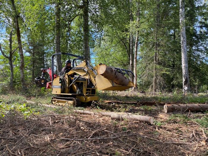
From the early 1990s through 2017, state and federal agencies installed about 15 miles of fuel break that protected the southern border of Alaska’s Kenai National Wildlife Refuge from catastrophic wildfire. It wasn’t easy work. It demanded years of creatively piecing together various funding sources, building partnerships with public and private entities, performing landscape-level planning, and coordinating implementation activities on the ground.
Now five years later and after two more wildfires that swept through the landscape in 2017 and 2019, that fuels reduction work has expanded onto private lands owned by Alaska Native entities along the north side of the Refuge. Partners have now completed 25 miles of fuel break and finished planning for an additional 10 to 15 miles of fuel break, bringing the total defensible perimeter to 35 to 40 miles.
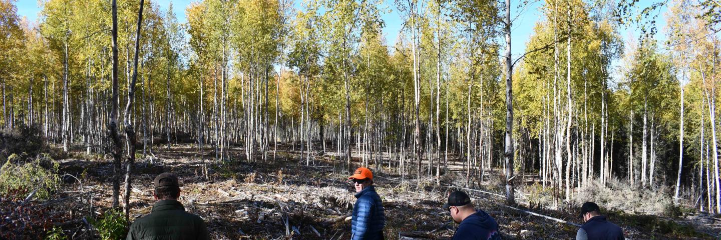
A fuel break is a strip of land on which the vegetation, debris and litter have been reduced or modified to control or diminish the spread of fire. Fuel breaks can significantly reduce the spread of wildfire resulting from excessive biomass accumulations, and they can also improve plant health and productivity and improve fish and wildlife habitat.
“The overarching goal is to protect homes and communities from wildfire risk by creating a defensible perimeter around the wildland-urban boundary,” said Nathan Lojewski, a forester with Chugachmiut.
Chugachmiut is a nonprofit Alaska Native organization that provides technical assistance to tribal communities including help with forest management and implementation of forest practices.
“Creating a defensible perimeter may also allow the Refuge to use fire as a tool to manage for moose habitat without threatening adjacent human development," Lojewski said.
Wildfire on the Kenai Peninsula
The Kenai Peninsula has about 60,000 year-round residents and the majority of them live within wildland-urban interface (WUI) zones. A WUI is a zone of transition between unoccupied land and human development. It is the line, area or zone where structures and other human development meet or intermingle with undeveloped wildland or vegetative fuels. And they are typically at high risk of wildfire.
On the Kenai Peninsula WUI, the wildlands are managed by the Kenai National Wildlife Refuge, the U.S. Forest Service Chugach National Forest, Alaska Native tribal corporations and entities, and land trusts. The Refuge is the largest landowner in the area, managing 150 to 180 miles of WUI along its border.
The urban lands include the towns of Sterling and Funny River, as well as the larger metropolitan centers of Soldotna and Kenai. The population in the Kenai Peninsula Borough is 3.7 people per square mile within just over 16,000 square miles.
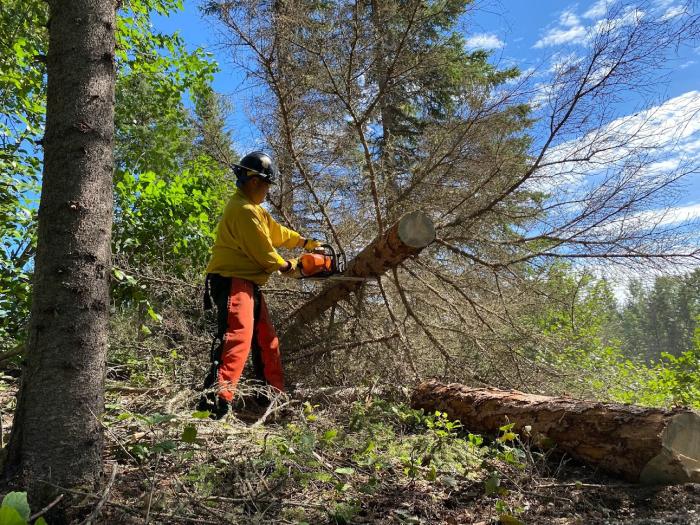
The area has seen more instances of catastrophic wildfire in recent years. The Funny River Fire in 2014 burned 195,000 acres; the East Fork Fire in 2017 burned a couple thousand acres; and the Swan Lake Fire in 2019 burned more than 180,000 acres. Most of the fuel these fires consumed was black spruce, which is highly flammable. Other trees on the landscape include birch, aspen, cottonwood, and white spruce.
“Black spruce is our problem fuel,” Lojewski said. “It’s extremely flammable. Firefighters call it 'gasoline on a stick.' It’s very difficult to control fire in a black spruce forest.”
Fortunately, the East Fork and Swan Lake Fires didn’t threaten urban areas because of recent fuel break treatments installed by this partnership.
“The Swan Lake Fire was able to be held north of the highway and it never threatened the community of Sterling,” Lojewski said. “The fuel break was a contingency line, if the firefighters couldn’t hold it there, they had the fuel break as a stopping point. Even though the fire was only a few miles away from town, Sterling didn’t have to evacuate. It also helped that the winds were not pushing west toward Sterling.”
Those fires further demonstrated the value of fuel breaks. Over the last five years, partners have focused on treating private lands along the north side of the Refuge boundary to protect the communities of Sterling, Salamatof, and Nikiski.
“It was always a big piece to the puzzle, how are we going to get the Alaska Native landowners involved in this project?” Lojewski said. “They own lands in strategic locations around the fuel break. For example, there is a powerline maintenance road along the perimeter of the fuel break that is on Native-owned land which would provide access for firefighters.”
Lojewski explained that typically planners try to avoid building fuel break lines with hard corners, because doing so makes it even more difficult for firefighters as they may have to fight fire on two sides of the corner. It’s much more efficient to build fuel breaks with straight lines so they can fight fire in one direction. So working on private lands was critical to achieve as many straight lines in the fuel break as possible.
Lengthening the fuel break’s protection
In 2016 the Natural Resources Conservation Service (NRCS) entered the partnership, which paved the way for fuel break treatments on private land. NRCS is a federal agency under the U.S. Department of Agriculture that provides free, voluntary technical and financial assistance to private farmers, ranchers, and forest owners to help them perform conservation practices, in this case, a fuel break.
NRCS worked with the Kenai Natives Association through the Environmental Quality Incentives Program (EQIP) providing financial assistance for about five miles of fuel break. Additional financial support using the Alaska Division of Forestry’s Forest Stewardship Program, combined with matching funds from the Bureau of Indian Affairs (BIA), allowed for 100 percent of the costs to be covered to treat the Native-owned lands.
“NRCS was thrilled to join this partnership and to help Kenai Natives Association perform fuels reduction on private lands,” said Meg Mueller, NRCS District Conservationist in Kenai. “The goal of this partnership is to install a long, linear fuel break along inhabited areas in the Central Kenai Peninsula, and to do that effectively, we must engage Alaska Native private landowners along the wildland urban interface. KNA has been great to work with and they are making a difference on the landscape.”
“I was fortunate to visit this project in 2020, shortly after joining the NRCS Alaska team,” said NRCS State Forester Chris Tcimpidis. “I was struck by the difference between the dense black spruce that occurred outside of the fuel break and the well-spaced, pruned trees within the fuel break. Without seeing the Kenai Peninsula, it is difficult to appreciate the essential nature of projects like this. But of equal importance is the partnerships between communities, regional corporations and government agencies resulting in the protection of communities and natural resources in these fire-driven ecosystems."
"This project highlights not just the importance in applied sciences to reduce fire risk, but the ability of diverse organizations and government agencies to successfully promote wise resource management across diverse land ownerships,” Chris said.
NRCS and the Forest Stewardship Program also helped fund a Conservation Activity Plan for the Salmatof Native Association, and implementation dollars for that portion of the fuel break came from multiple partners including the Homer Soil and Water Conservation District, Chugachmiut, BIA and Alaska Division of Forestry.
“Trying to piece together the funding can be challenging, because there are so many different sources of grant funding and different agencies, but that is the great thing about this partnership,” Lojewski said. “We identified which agencies had funding and figured out how to make it work, whether that was through agreements, or pass-through funds to contract public funds on private lands, and by leveraging match funding with other sources.”
Private landowners with the Kenai Natives Association, Cook Inlet Regional Corporation, and Salamatof Native Association are now a part of the planning and implementation.
“The fuel break will mitigate fire risk and keep fire out of the populated areas,” said Vernon Stanford, president of KNA. “Before the work took place, the stands were dense, thick and full of dead black spruce affected by beetle kill. We are happy with the results so far and we are glad to be a part of this partnership.”
Story and photos by Tracy Robillard, NRCS Alaska Public Affairs Specialist.