
NRCS, EPA & RI Department of Environmental Management identified significant water quality impairments from excess nutrients and pathogens in waterbodies within the Tomaquag watershed. This water quality degradation negatively impacts several coastal lagoons and drinking water supply sources.
For fiscal year 2025, Rhode Island NRCS is funding NWQI implementation practices through EQIP for the Tomaquag Brook-Pawcatuck River watershed (HUC-12: 010900050205) in southwestern Rhode Island. Farmers and ranchers within the 57 square mile watershed’s boundaries are encouraged to apply for financial assistance from NRCS to address water quality degradation on or stemming from their operations.
Available funding will prioritize conservation practices that reduce movement of sediment, nutrients and pathogens; concentrated soil erosion; and agricultural pollutants including fertilizers and manure from agricultural operations to surface and ground water sources. The signup cut-off date for the third round of fiscal year 2025 funding was February 28, 2025.
Background
The Tomaquag Brook-Pawcatuck River watershed land area is about 75% forested. Agricultural land makes up a little over 5% of the area and is located mainly in the southwestern corner of the state, bordering Connecticut. Production is primarily forage (hay/non-alfalfa) and corn. Developed land makes up about 11% of the land area.
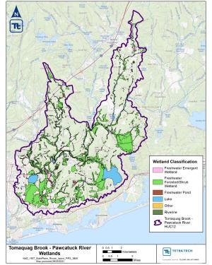
A National Water Quality Assessment completed in 2024 for the Tomaquag Brook-Pawcatuck River watershed identified critical source areas for nonpoint source pollution in agricultural fields. High levels of phosphorus and metals are the main water quality concerns for the Tomaquag Brook-Pawcatuck River watershed. White Brook Pond and Chapman Pond are impaired due to high levels of phosphorus; Chapman Pond is also exceeding lead criteria. Meadowbrook Pond and Watchaug Pond also contain high levels of mercury, evident via the accumulation within fish tissue.
Numerous stream segments exceed recreational water quality standards for Enterococcus (indicating the potential presence of pathogenic organisms) and have approved Total Maximum Daily Loads (TMDLs) (RIDEM 2021). Recent U.S. Geological Survey (USGS) water quality monitoring data also indicates elevated levels of nutrients (nitrogen and phosphorus) occurring episodically at sites on Tomaquag Brook and Pawcatuck River.
The funding for Tomaquag Brook-Pawcatuck River watershed is a key component of the strategy to improve water quality in southern Rhode Island’s surface waters, improve recreational water quality for residents, and support conservation practice installation by farmers on their land to protect their natural resources. Implementation of conservation practices not only supports farmers but also has positive impacts on communities within the watershed.
Tomaquag Brook-Pawcatuck River Watershed Assessment
Contact
Additional Information
National Water Quality Initiative - Rhode Island
As USDA’s premiere water quality initiative, National Water Quality Initiative (NWQI) provides a way to accelerate voluntary, on-farm conservation investments and focused water quality monitoring and assessment resources where they can deliver the greatest benefits for clean water.
Learn MoreEnvironmental Quality Incentives Program - Rhode Island
The Environmental Quality Incentives Program (EQIP) provides financial and technical assistance to Rhode Island farmers, woodland owners, oyster growers, livestock producers, and urban growers to address natural resource concerns in the Ocean State.
Learn More