
This Regional Conservation Partnership Program (RCPP) project will use conservation easements to protect small but critical properties that possess significant conservation values in Montana's Bitterroot Valley.
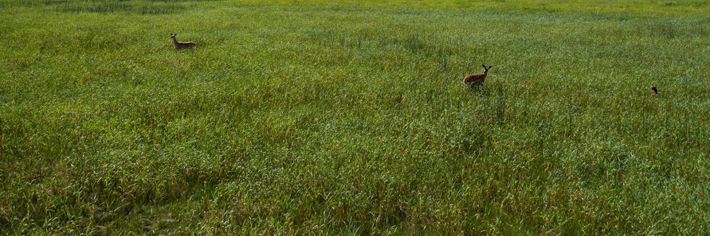
This Regional Conservation Partnership Program (RCPP) project proposes to use conservation easements to protect small but critical properties that possess significant conservation values in the Bitterroot Valley. Preservation of these properties will help protect prime agricultural land, improve soil health and enhance habitat connectivity for the abundant wildlife in the Bitterroot.
Who Can Participate?
Landowners in Ravalli County
Benefits to the Land
- Improved soil health
- Improved water quality and quantity
- Reduced loss of nutrients and organics into surface water
- Enhanced wildlife habitat connectivity
Partners
- Bitter Root Land Trust (lead partner)
- Ravalli County Right to Farm & Ranch Board
- Ravalli County Local Working Group
- Ravalli County Open Lands Board
- Montana Association of Land Trusts
Eligible Land Uses
- Crop
- Forest
- Range
- Pasture
- Farmstead
- Developed Land
- Water
- Other Rural Land
- Associated Ag Land
Eligible Practices
Long-Term Protection of Land - Permanent Easement through an Agricultural Conservation Easement Program - Agricultural Land Easement
When to Apply
Program applications are accepted on a continual basis. However, NRCS establishes application ranking dates for evaluation, ranking and approval of eligible applications. Applications received after the ranking date will be automatically deferred to the next funding period. See Montana Programs and Application Dates.
Local Ranking Questions
- Size of parcel
- Equal to or greater than 150 acres
- 90 acres to less than 150 acres
- 60 acres to less than 90 acres
- 50 acres to less than 60 acres
- Less than 50 acres
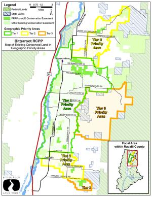
- Proximity to a Bitter Root Land Trust designated Bitterroot RCPP Priority Area
- Easement offer area (EOA) is within 1 mile of a priority area
- EOA is within 1/2 mile of a priority area
- EOA boundary is within a Tier 3 priority area
- EOA boundary is within a Tier 2 priority area
- EOA boundary is within a Tier 1 priority area
- EOA is greater than 1 mile from a priority area
- Percent of prime, unique, statewide, or locally important farmland in the parcel to be protected.
- 75% and above
- 51 to 74%
- 25 to 50%
- Less than 25%
- Proximity of the parcel to other protected land, such as land owned in fee title by the United States or an Indian Tribe, State or local government, or by a nongovernmental organization whose purpose is to protect agricultural use and related conservation values; or land that is already subject to an easement or deed restriction that limits the conversion of the land to nonagricultural use or protects grazing uses and related conservation values.
- Easement Offer Area (EOA) boundary greater than 2 miles from the protected land boundary
- EOA is greater than 1 mile but less than 2 miles from protected land boundary
- EOA is within a mile of protected land boundary
- EOA is within 1/2 mile of protected land boundary
- EOA boundary adjoins protected land boundary
- Easement Offer Area (EOA) includes following characteristics; includes riparian habitat (5 points, includes a perennial or intermittent stream (5 points), includes habitat of Bull Trout or Westslope Cutthroat Trout (5 points), is an impaired Stream (Clean Water Act Section 303(d))or is within the drainage basin (HUC) of an Impaired Stream.
- Easement offer area (EOA) includes none of these characteristics
- EOA includes one of these characteristics
- EOA includes two of these characteristics
- EOA includes three of these characteristics
- EOA includes all four of these characteristics
- Number of legal parcels included in the Easement Offer Area
- 1 parcel
- 2 to 5 parcels
- 5 to 10 parcels
- Greater than 10 parcels
- Easement Offer Area contains the habitat of species of concern and/or federally listed or candidate endangered species.
- No species of concern, endangered, or candidate endangered species habitat occurs within the Easement offer area (EOA)
- One species of concern's habitat occurs within the EOA
- Two species endangered, or candidate endangered species habitat occurs within the EOA
- Any combination species of concern or endangered or candidate endangered species' habitat occurs within the EOA
- Is the farm or ranch a specialty crop production operation or diversified agricultural operation
- Yes
- No
Contact
To apply, contact the Bitter Root Land Trust at 170 S 2nd Street, Suite B, Hamilton, MT 59840 or 406-375-0956.
Ready to get started?
Contact your local service center to start your application.
How to Get Assistance
Do you farm or ranch and want to make improvements to the land that you own or lease?
Natural Resources Conservation Service offers technical and financial assistance to help farmers, ranchers and forest landowners.
To get started with NRCS, we recommend you stop by your local NRCS field office. We’ll discuss your vision for your land.
NRCS provides landowners with free technical assistance, or advice, for their land. Common technical assistance includes: resource assessment, practice design and resource monitoring. Your conservation planner will help you determine if financial assistance is right for you.
We’ll walk you through the application process. To get started on applying for financial assistance, we’ll work with you:
- To fill out an AD 1026, which ensures a conservation plan is in place before lands with highly erodible soils are farmed. It also ensures that identified wetland areas are protected.
- To meet other eligibility certifications.
Once complete, we’ll work with you on the application, or CPA 1200.
Applications for most programs are accepted on a continuous basis, but they’re considered for funding in different ranking periods. Be sure to ask your local NRCS district conservationist about the deadline for the ranking period to ensure you turn in your application in time.
As part of the application process, we’ll check to see if you are eligible. To do this, you’ll need to bring:
- An official tax ID (Social Security number or an employer ID)
- A property deed or lease agreement to show you have control of the property; and
- A farm number.
If you don’t have a farm number, you can get one from USDA’s Farm Service Agency. Typically, the local FSA office is located in the same building as the local NRCS office. You only need a farm number if you’re interested in financial assistance.
NRCS will take a look at the applications and rank them according to local resource concerns, the amount of conservation benefits the work will provide and the needs of applicants. View Application Ranking Dates by State.
If you’re selected, you can choose whether to sign the contract for the work to be done.
Once you sign the contract, you’ll be provided standards and specifications for completing the practice or practices, and then you will have a specified amount of time to implement. Once the work is implemented and inspected, you’ll be paid the rate of compensation for the work if it meets NRCS standards and specifications.