
Global Soil Map
GlobalSoilMap Consortium; International Union of Soil Scientists (IUSS), United Nations - Food and Agriculture Organization (UN-FAO); University of West Virginia
Project Name: GlobalSoilMap
Project Members/Collaborators: GlobalSoilMap Consortium; International Union of Soil Scientists (IUSS), United Nations - Food and Agriculture Organization (UN-FAO); University of West Virginia
Relevance
United States Department of Agriculture - Natural Resources Conservation Service (USDA-NRCS) is a member of the GlobaSoilMap Consortium and a partner of the UN-FAO Global Soil Partnership (GSP) initiative. The main focus of the GSM and GSP is to promote sustainable soil management to address
food security and nutrition,
ecosystem services
biodiversity; and
soil degradation.
This aligns with the USDA-NRCS main focus of providing leadership in a partnership effort to help people conserve, maintain and improve our soils and other natural resources and environment. Soil Science Division has released the gridded Soil Survey Geographic Database (gSSURGO) in support of such efforts.
Project Objectives
To create a new digital soil map of the world using state of the-art and emerging technologies. This new GlobalSoilMap will include prediction of soil properties at fine spatial resolution (~100 m) with uncertainties of predictions. These data will be supplemented by interpretation and functionality options to support improved decisions for a range of global issues such as food production and hunger eradication, and environmental degradation as well as local issues related to resource management and conservation.
Approach
Each nation is responsible for generating the soil property maps following flexible methodologies which is dictated from differences in methodologies, standards and current products available, but that would meet the GSM standards and Specifications as highlighted in Project Objectives. The GSM has developed the “tiering” or “versioning” concept that would allow nations to develop the first generation of soil property maps based on existing legacy soil data and information and continue to improve the products as more information and data becomes available. This bottom up approach supports nations in building capacities for generating such products and making them available for free to users.
Expected Outputs
The high resolution of soil maps will be generated for 6 standard depth intervals based on equal area spline functions (0-5; 5-15; 15-30; 30-60; 60-100; and 100-200cm) for twelve soil properties (total profile depth-cm; plant exploitable (effective) soil depth-cm; organic carbon-g/kg; pH1:5 water; sand-g/kg; silt-g/kg; clay-g/kg; gravel-m3 m-3; ECEC-cmolc/kg; bulk density (< 2 mm) fraction-Mg/m3; bulk density of the whole soil in situ (includes gravel)-Mg/m3; and available water capacity-mm. A wide range of pedotransfer functions are also available and/or will be developed to harmonize the data from different analytical methodologies.
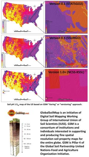
Products
Version 0.1 of GSM for United States based on U.S. General Soil Map (STATSGO2)
Version 0.5 of GSM for the United States based on Soil Survey Geographic Database (SSURGO)
Published Articles
Libohova, Z., S. Wills, N.P. Odgers, R. Ferguson, R. Nesser, J.A. Thompson, L.T. West, and J.W. Hempel, 2014. Converting pH 1:1 H2O and 1:2 CaCl2 to 1:5 H2O to Contribute to a Harmonized Global Soil Database. Geoderma. DOI:10.1016/j.geoderma.2013.08.019.
Libohova, Z., S. Wills, J.W. Hempel, N P. Odgers, and J. Thompson. Using Pedo-Transfer Functions for Estimating Soil pH and Bulk Density at Regional Scale. Published at the 5th Global Workshop on Digital Soil Mapping, 2012 proceedings, pages 313–316. CRC Press. ISBN: 978-0-415-62155-7.
Odgers, N.P., Z. Libohova, and J.A. Thompson, 2012. Equal-Area Spline Functions Applied to a Legacy Soil Database to Create Weighted-Means Maps of Soil Organic Carbon at a Continental Scale. Geoderma (2012). DOI:10.1016/j.geoderma.2012.05.026.
Odgers, N.P., Thompson, J.T., Libohova, Z., McBratney, A.B., 2012. Uncertainty estimation for weighted-means digital soil maps. Digital Soil Assessments and Beyond – Minasny, Malone & McBratney (eds). © 2012 Taylor & Francis Group, London, ISBN 978-0-415-62155-7.
Hempel, J.W., Z. Libohova, N.P. Odgers, J.M. Thompson, S.S. Smith, and G.L. Lilek, 2012. Versioning of GlobalSoilMap.net Raster Property Maps for North America Node. Published at the 5th Global Workshop on Digital Soil Mapping, 2012 proceedings, pages 429–433. CRC Press. ISBN: 978-0-415-62155-7. DOI: 10.13140/2.1.4670.2404.
Libohova, Z., S. Wills, and N.P. Odgers, 2013. Legacy Data Quality and Uncertainty Estimation for United States GlobalSoilMap Products. GlobalSoilMap Conference Proceeding, Orleans, France. Edited by Dominique Arrouays, Neil McKenzie, Jon Hempel, Ann C. Richer de Forges, and Alex McBratney. CRC Press 2014, pages 63–68. Print ISBN: 978-1-138-00119-0, eBook ISBN: 978-1-315-77558-6, DOI: 10.1201/b16500-18.
Hempel, J. W., Z. Libohova, J.A. Thompson, N.P. Odgers, C.A.S. Smith, G.W. Lelyk, and G.E.E. Geraldo, 2013. GlobalSoilMap North America Node progress. GlobalSoilMap Conference Proceeding, Orleans, France. Edited by Dominique Arrouays, Neil McKenzie, Jon Hempel, Ann C. Richer de Forges, and Alex McBratney. CRC Press 2014, pages 41–45. Print ISBN: 978-1-138-00119-0, eBook ISBN: 978-1-315-77558-6, DOI: 10.1201/b16500-18.
Hempel, J., A.B. McBratney, D. Arrouays, N. McKenzie, A.E. Hartemink, M. Grundy, M. Greve, S-Y. Hong, G. Lelyk, and Z. Libohova, 2014. GlobalSoilMap and Global Carbon Predictions. In A.E. Hartemink and K. McSweeney (eds.), Soil Carbon. Progress in Soil Science, DOI 10.1007/978-3-319-04084-4_36, © Springer International Publishing, Switzerland.
Libohova, Z., Odgers, N.P., Ashtekar, J.M., Owens, P.R., Thomson, J.A., Hempel, J, 2016. Some challenges on quantifying soil property predictions uncertainty for the GlobalSoilMap using legacy data. G. Zhang et al. (erd), Digital Soil Mapping Across Paradigms Scales and Boundaries, Springer Environmental Science and Engineering, DOI 10.1007/978-981-10-0415-5_11.