
Dynamic Soil Properties Under Cultivated and CRP Land Uses
Dynamic Soil Properties Under Cultivated and CRP Land Uses
Project Name: Dynamic Soil Properties under Cultivated and CRP Land Uses in West Fork Beaver Creek Drainage Basin, MLRA 103, Minnesota
Project Members: Candiss O. Williams, NSSC, candiss.williams@lin.usda.gov; Skye Wills, NSSC, skye.wills@lin.usda.gov; Cathy Seybold, NSSC, cathy.seybold@lin.usda.gov; John Beck, Minnesota NRCS, john.beck@mn.usda.gov; Doug Wysocki, NSSC, doug.wysocki@lin.usda.gov; Steve Montieth, NSSC, steve.montieth@lin.usda.gov; Zamir Libohova, NSSC, zamir.libohova@lin.usda.gov
Cooperators: Tanja N. Williamson, USGS, tnwillia@usgs.gov; Victoria Christensen, USGS, vglenn@usgs.gov; Kristina Walker, University of Minnesota-Crookston, kswalker@crk.umn.edu; Joshua Gates, University of Nebraska-Lincoln, Senior Project
Relevance
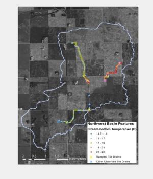
Figure 1: West Fork Beaver Creek Basin (USGS).
In the Minnesota River Basin, MN, state and federal programs have been implemented to encourage retirement of agricultural land. These programs include installation of retired riparian corridors (RRC) which are aligned with CRP, CREP, and MN RIM programs. The West Fork Beaver Creek Drainage Basin (Figure 1) was chosen by the U.S. Geological Survey (USGS) to evaluate the impact of RRC on water quantity and quality due to the high rate of agricultural land retirement. Previous studies in the basin observed that as retired land area along the riparian corridor increased, there were significant decreases in nitrogen and sediment transport but not in phosphorus transport (Christensen et al., 2012). Phosphorus (P) is one of the leading causes of water quality decline in the US. High P levels in water can lead to algal blooms and hypoxia in surface waters. Decreasing conservation dollars dictate that NRCS maximizes its effectiveness and efficiency in implementing practices to address P management and runoff on agricultural lands. Therefore, additional information on P behavior in soil is needed to better identify areas that are at risk to deliver excess P to surface waters.
In addition to understanding P behavior in soil, changes in dynamic soil properties are important to understand the response of soils to changes in land use or management. Changes in management, and hence dynamic soil properties, may result in a change in measurable soil properties, including aggregate stability, infiltration, water holding capacity, bulk density, nutrients, etc. Because these properties have an effect on nutrient and water availability and resistance to erosion, they also impact production. Dynamic soil properties are important to Soil Survey and to NRCS conservation planning as its purpose is to define, document, and interpret how changes in soil properties, and therefore their interpretations, change in relation to various land uses and management systems (TSSH 623). In addition, increased availability of dynamic soil property information will allow the development and/or improvement of management tools that support sustainable management.
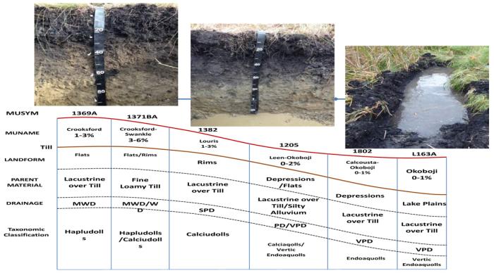
Figure 2: Soils in the northwest sub-watershed of the West Fork Beaver Creek Drainage Basin.
Approach
Soils in the northwest sub-watershed of the West Fork Beaver Creek Drainage Basin (Figure 2) where ongoing USGS water quality sampling is occurring will be sampled and will represent the major soil series that drain to the point where water sampling occurs. Samples of the upper 50 cm of the soil profile will be analyzed for a suite of chemical and physical properties to include organic matter, particle size, bulk density, and total N and P. Phosphorus sorption and/or desorption isotherms will be performed to determine the potential for soils to transport P to adjacent water bodies. In addition, the Agricultural Policy Environmental eXtender (APEX) model will be calibrated and validated to evaluate the impact of retired agricultural land on water quality and quantity as well as dynamic soil properties.
Use of the Data
At the field level, soil characterization data will assist SSURGO users with planning and management within the study watershed. Data on P sorption characteristics and associated P loading potential can assist NRCS conservation planners in identifying areas with greater risk for P transport. Evaluating dynamic soil properties within the watershed will contribute to the knowledge of management influences and its impact on soil quality. Quantifying the benefits of riparian areas on water quality and quantity via APEX modeling will assist conservation planners and land managers with conservation planning.
Expected Outputs and Products
Soil characterization data will be made public via NASIS;
Soil P sorption characteristics will be used to evaluate current potential for P losses within the West Fork Beaver Creek Basin;
Dynamic soil properties under different management practices will be evaluated;
Simulated data via APEX will be used to evaluate changes in dynamic soil properties with management as well as the impact of land use change on water quality and quantity;
Calibration and validation of the watershed using APEX will benefit the Conservation Effects Assessment Project (CEAP);
Training of soil scientists; and
The study will improve the relationship of NRCS with other federal and state agencies and local landowners.
Publications
Williams, C.O., T. Williamson, J. Beck, S. Wills, C. Seybold, V. Christenson, B. Richardson, S. Monteith, and K. Walker. 2015. Multi-Agency Effort to Quantify Benefits of Conservation Programs in West Fork Beaver Creek Watershed, Minnesota (Poster Presentation). National Cooperative Soil Survey National Conference, Duluth, Minnesota.
†Gates, J., C.O. Williams, R.A. Young, R.A., C. Seybold, S. Wills, D. Wysocki. 2015. Effect of Landscape Position on Soil Phosphorus Sorption Characteristics on Retired Agricultural Land (Poster Presentation), National Cooperative Soil Survey National Conference, Duluth, Minnesota.
Williams, C.O. Dynamic Soil Properties under Cultivated and Restored Wetlands. National Cooperative Soil Survey Newsletter November 2014, Issue 69.
Williams, C.O. Dynamic Soil Properties under Cultivated and CRP Land Uses in West Fork Beaver Creek Drainage Basin Renville County, Minnesota. Fact Sheet. 2013.