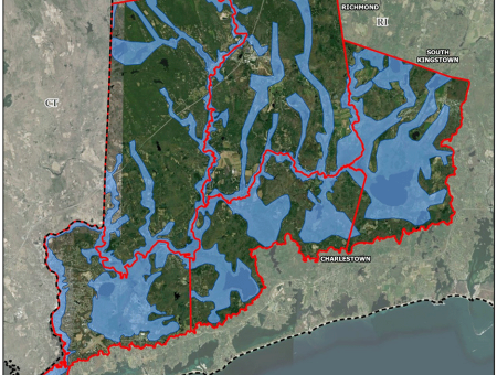
Project partners are developing a Watershed Plan to identify priority actions to protect and enhance the flood resiliency in the Wood-Pawcatuck watershed and to improve river and stream ecosystems, including water quality and habitat.
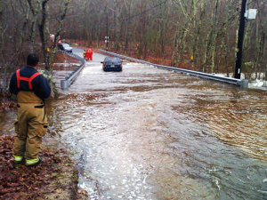
The Wood-Pawcatuck watershed (1/4 of RI) has historically been challenged with riverine and drainage-related flooding in developed areas. Watershed communities have suffered extensive flooding and flood-related damages, with the most extreme flooding on record having occurred in the March and April floods of 2010. The incredible amount of precipitation (over 16") that fell in February and March 2010, along with saturated soils, high water tables, lack of leaf cover and limited pervious surfaces all contributed to the worst flooding ever documented along the Pawcatuck River and in many other areas of Rhode Island.
Several factors contribute to flooding in the watershed. Historical development in the watershed has resulted in filling of wetlands, floodplains and floodways, which has reduced natural flood storage and placed development in flood-prone areas. Many streams in the watershed have also been physically modified (i.e., moved, straightened, hardened), which can increase riverine erosion hazards in certain areas. Development of the landscape with roads, parking lots, and buildings – impervious surfaces that prevent rainfall from infiltrating into the ground naturally – has increased the amount of storm runoff. Stormwater drainage infrastructure in developed areas also quickly conveys runoff to rivers and streams. Undersized bridges and culverts also contribute to flooding and erosion. Dams within the watershed can help to attenuate flood flows while also creating hazards by backing up water during major floods or by releasing very large quantities of flow, sediment, and debris in the event of a sudden failure.
Rainfall in New England is expected to continue to increase, which will increase the risk of river-related flooding in the future. Bridges, roads and dams will be more susceptible to flood damage because of more severe storms and heavy rainfall. Therefore the need to address flood resiliency in the watershed is great.
Watershed Facts
• 303 square miles
• 87% of land area is undeveloped or agricultural
• 75% of land area is non-industrial forest land
• Designated as National Wild & Scenic Rivers in March 2019
• 24 miles of ‘wild’ river segments
• Longest Wild & Scenic River System in New England (110 miles)
• Contains 75% of all animal species found in RI
• Includes 70% of globally rare & 63% of RI’s rare species and natural communities
• Darkest sky region between Washington, DC & Boston
• Over 300 farms in watershed registered with RI Farm Forest & Open Space program
• 21,303 acres of Prime Farmland
• 23,988 acres of Statewide Important farmland
• Over 83,000 residents
About the Watershed

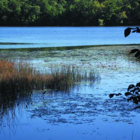
The Wood-Pawcatuck watershed is characterized by its large tracts of deciduous forest and is noted for having the largest, most undisturbed forest lands remaining between Boston and New York City. The forest landscape is home to many unique habitats and rare species that exist in the watershed. Forest cover ranges from a low of approximately 22% in the Lower Pawcatuck River subwatershed to a high of approximately 70% in the Upper Wood River subwatershed. An additional 9% of the watershed is categorized as undeveloped upland habitat including shrub/scrub and grassland habitats. Forested wetlands also make up a large percentage of the various wetland types in the watershed.
There are two main population centers within the watershed – one in Westerly, RI, and Pawcatuck, CT, along the estuary portion of the Pawcatuck River, and another in South Kingstown, RI, on the eastern side of the watershed. The rest of the watershed is predominantly rural wooded landscape amongst a series of towns that developed as mill villages along the Pawcatuck River and its tributaries. The watershed is also home to Narragansett Indian tribal land in Charlestown, RI.
Project Goals & Objectives
This project will build on a previous flood resiliency management plan completed for the Wood-Pawcatuck Watershed Association in 2017. The new plan will be updated to NRCS standards, utilizing watershed data compiled as part of the previous flood resiliency plan to inform alternatives that will be developed and evaluated. This approach will maximize the investment made by NRCS in developing a Watershed Plan.
The primary goals and expected outcomes of the watershed management plan include:
- Protect and enhance the resiliency of the watershed communities to future flood damages.
- Maintain and improve the viability of agricultural and forested land.
- Strengthen and restore natural ecosystems, water quality, species and habitat, while increasing flood resiliency.
- Help watershed communities (local and state governments and private land owners) prepare for and mitigate the impacts of future severe storms.
- Protect critical community infrastructure and the ability of communities to deliver vital municipal services.
- Protect and enhance fish and wildlife species and habitats.
- Help communities understand watershed and riverine processes so that better land use and infrastructure investments can be made.
- Strengthen local land use policies and regulations to enhance flood resilience.
- Improve the quality of life, recreational opportunities, and economic viability of watershed communities.
- Facilitate capacity-building and engage watershed municipalities and other stakeholder groups in the watershed planning process and future plan implementation.
- Promote collaboration across municipal boundaries, bringing watershed communities and groups together to cooperate around shared issues of concern and objectives without compromising their “home rule” principles.
Project Partners
- Southern Rhode Island Conservation District - Sponsor
- The Town of Westerly, RI - Sponsor
- The Town of Richmond, RI - Sponsor
- The Town of Hopkinton, RI - Sponsor
- The Town of Charlestown, RI - Sponsor
- The Town of South Kingstown, RI - Sponsor
- The Town of Stonington, CT - Sponsor
- The Town of North Stonington, CT - Sponsor
- The Town of Voluntown, CT - Sponsor
- Wood-Pawcatuck Watershed Association