
Monthly Water Supply Outlook Reports (WSOR) are available by the fifth business day of each month January through June. The report summarizes current conditions related to water supply across Montana including precipitation, snowpack, temperature, streamflow, drought status, and weather outlooks. It also contains the most recent water supply forecasts for the upcoming spring and summer season.
Water Year 2025 - Water Supply Outlook Reports

January 1, 2025
Following a slow start to the snowpack accumulation season, snowy weather during the last week of December and first week of January has drastically improved snowpack conditions. The largest snowfall accumulations occurred in western and northwest Montana, while northern Wyoming basins benefited less from the late-December storms. Despite recent improvements, snowpack percentages remain slightly below normal across most of Montana. The exceptions are northwest Montana and the Bears Paw Mountains which have a slightly above normal snowpack. For the rest of the state, the lack of snowfall during October and November created a deficit that will require sustained snowfall to overcome.

February 1, 2025
Snowpack accumulation during January varied drastically across the state. In northwest Montana, an above normal January 1 snowpack dropped to below normal after receiving minimal precipitation the second half of January. In contrast, a strong storm system hit central Montana resulting in well above normal snowpack for February 1. The Gallatin, Powder, and Tongue River basins had above normal precipitation during January, but following a slow start to the season the snowpack in these regions is still below normal. Consistent smaller storms across the rest of the state resulted in below to near normal precipitation, which maintained the below normal snowpack conditions from January 1.

March 1, 2025
February was a month of steady snow accumulation in Montana. Most basins have near to below normal snow water equivalent (SWE). Colder temperatures for most of the month ushered in winter weather. The warm and sunny conditions near the end of the month slowed snow accumulation in most areas. Most snow courses and SNOTELs had SWE values in the range of 2” below to 1” above normal at the end of February. The map below shows snow measuring station departure from median SWE at the end of February. Some snow monitoring stations in the northwest Montana and the Rocky Mountain Front have larger SWE deficits. Dry January conditions and a slow start to water year precipitation accumulation allowed enough time for SWE deficits to increase. However, with snow accumulations in February the deficits decreased, and SWE values got closer to normal. Deficits also exist in soil moisture across the state. Most of the state remains in drought conditions, despite the steady snow accumulations.

April 1, 2025
March started off with little to no snow accumulation in most areas. The lull in accumulation gave time for snow water equivalent (SWE) deficits to increase in some locations. Near the middle of the month most areas began accumulating snow once again. By the end of the month most stations had SWE values that climbed closer to normal. Most stations in the southwest part of the state have SWE values close to normal. The northwest part of the state and the Rocky Mountain Front have more stations with below normal SWE. Deficits from earlier in the winter persist in these areas.

May 1, 2025
April ushered in spring conditions in Montana. Variable temperatures and weather effected snowpack across the state. Many sites experienced a halt to snow accumulation during this time. Scattered winter storms caused accumulation to momentarily restart at certain sites. Accumulation continued at higher elevations throughout the month. Widespread melt occurred at lower and mid elevation stations. With some stations melting out completely. Higher elevations experienced some snowmelt with SWE beginning to decrease near the end of the month.

June 1, 2025
With summer in Montana just around the corner, warmer than normal May temperatures ushered in the seasonal transition and spurred rapid snowmelt. May precipitation varied drastically across the state. Northwest Montana and the Gallatin, Upper Yellowstone, and Bighorn basins had below normal May precipitation. Southwest, central Montana, and the Powder and Tongue basins experienced near to above normal May precipitation. This brings the water year precipitation to near normal across most of the state, and below normal in northwest Montana. The warm temperatures swiftly shepherded in spring runoff. Snowpack across Montana is 25%-70% of median, well below normal for June 1. This is a drastic drop from May 1 where snowpack was largely 75%-110% of median. One exception is the Bighorn Mountains, where June 1 snowpack in associated basins is 75%-120% of median.
Water Year 2024 - Water Supply Outlook Reports
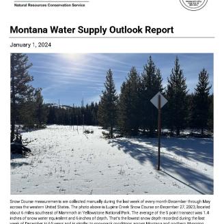
January 1, 2024
Warm temperatures and lack of precipitation over the last couple months have resulted in a bleak start to the seasonal snowpack in Montana and northern Wyoming. Precipitation since October 1 has mostly been well below normal. As a result, the snowpack is currently about 30-60% of what it normally is this time of the year, except for part of the southern Absaroka and Wind River Mountains. Currently many NRCS snow monitoring stations in the region are reporting their lowest snowpack on record. Additionally, temperatures have been significantly warmer than normal during the last two months, as a result the snowpack has experienced some melt.

February 1, 2024
An early January storm brought hope that normal winter weather had finally arrived. After record setting cold temperatures settled in mid-month for about a week, well above normal temperatures accompanied by dry weather returned and persisted during the last two weeks of January in all but the northern Flathead and Kootenai River basins.
Most basin wide snowpack percentages haven’t changed much since January 1, and are still well below normal. Above normal precipitation was needed to make significant gains on the snowpack deficit, yet January precipitation was below normal in all but the Kootenai River basin. Currently, all snowpack percentages are below normal.

March 1, 2024
Following an exceptionally slow start to the water year, winter weather arrived in February and provided much needed precipitation to the region. Precipitation last month was above normal in all but the northern Bighorn Mountains. Snowpack percentages have increased in all basins, but overall, the snowpack remains below normal. The recent improvements were timely, but there are only one to two months remaining in the normal snow accumulation season and more snow is needed.

April 1, 2024
Given the lack of precipitation from November through much of January in Montana, above normal precipitation was needed over the last couple of months to begin to catchup on snowpack and precipitation. February provided well above normal precipitation to nearly all of Montana. Basins such as the Jefferson and Upper Missouri received over 150% of normal precipitation during February and those weather patterns continued into the first week of March across much of Montana. What seemed to be the beginning of a potential recovery tapered off after the first week of March in many basins. Overall precipitation was above normal in southwest and southern Montana, but mostly below normal elsewhere.

May 1, 2024
Well above normal precipitation during April was needed given the meager snowpack conditions experienced this year. Total monthly precipitation was above normal last month in the Powder and Tongue River basins, but was not widespread across Montana. A couple mid-month storms did provide significant snowfall, but April is typically a wet month in Montana, and total precipitation last month did not meet that standard. April precipitation was overall about 65-80% of normal with a couple of isolated locations that were higher. For example, the Gallatin and Bitterroot received about 90-95% of normal April precipitation. Spring weather in Montana can be highly variable, with a storm that is currently adding to the snowpack as this report is being prepared. While this is exactly what is needed, this one storm alone will not likely make up for the water year precipitation deficit across most of western Montana. Water year precipitation is 75-85% of normal for most of the state. Northern Wyoming basins and the upper Madison have fared slightly better and are currently at 90-100% of normal water year precipitation.

June 1, 2024
Summer is fast approaching and as Montana wraps up the 2024 snow accumulation season recent weather helped improve the water supply outlook, however the outlook remains below normal in many locations. Last month brought a mix of snow, rain, and sunshine across Montana. While that is not uncommon weather for this time of the year, some locations did not receive the moisture they needed. The Kootenai, Lower Clark Fork, Jefferson, and upper Madison River basins experienced below normal precipitation last month. All other basins received above normal precipitation, and some of the storm totals were exceptional. Periods of cool weather delayed snowmelt and increased snowpack percentages in many basins. The Gallatin, Smith-Judith Musselshell, Powder, and Tongue saw the largest increases. June 1 snowpack percentages currently range greatly, from well above normal in the Bighorn Mountains to well below normal around Helena and the Rocky Mountain Front.
Water Year 2023 - Water Supply Outlook Reports
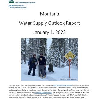
January 1, 2023
Snow Surveyors Elena Garcia and Zachary Denison measuring Norris Basin Snow Course in Yellowstone National Park on January 1, 2023. They found 4.4” of snow water equivalent at the snow course, which is above normal for January 1 and similar to conditions across the rest of the region. The snowpack is off to a good start this year and across Montana conditions are currently above normal. The timing of snowpack onset this season was near normal, and precipitation has been consistent since October, however there are still 3 to 4 months left in the snowpack accumulation season. Continued active weather in the months ahead will be necessary to reach normal spring snowpack levels.
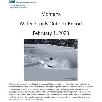
February 1, 2023
Although much of January consisted of sunny days without precipitation, a major winter storm during the last week of the month added to the snowpack while also improving snow conditions for recreationalists. This storm provided some locations in Montana with two to three feet of snow. While this storm was beneficial, most snowpack percentages decreased over the last month. The snowpack currently ranges from below normal in northwestern Montana and the Rocky Mountain Front to above normal in central Montana. With two to three months remaining in the typical snowpack accumulation season, some uncertainty remains in terms of what spring snowmelt will provide for water supply.
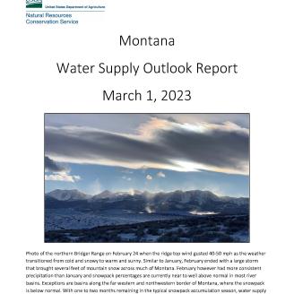
March 1, 2023
Photo of the northern Bridger Range on February 24 when the ridge top wind gusted 40-50 mph as the weather transitioned from cold and snowy to warm and sunny. Similar to January, February ended with a large storm that brought several feet of mountain snow across much of Montana. February however had more consistent precipitation than January and snowpack percentages are currently near to well above normal in most river basins. Exceptions are basins along the far western and northwestern border of Montana, where the snowpack is below normal. With one to two months remaining in the typical snowpack accumulation season, water supply forecasts are now available statewide.
April 1, 2023
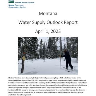
Photo of Montana Snow Survey Hydrologist Colin Kultys surveying Slag-A-Melt Lake Snow Course in the Beaverhead Mountains on March 28, 2023, a region that experienced active weather in March and rebounded from below normal conditions last month. Excluding Northwest Montana and the Rocky Mountain Front, March precipitation was above normal in Montana. Central Montana and Southwest Montana continued to build on an already exceptional snowpack. Peak snowpack season is upon us and much of the snowpack east of the Continental Divide is near or already exceeding normal peak levels. Snowpack conditions across the state are largely above normal, except in the far northwest region of Montana. April 1 streamflow forecasts are now available in the following report.
May 1, 2023
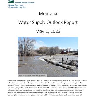
Warm temperatures during the week of April 10th resulted in significant melt of snowpack below mid-mountain elevations across Montana. The photo above shows the Shields River near Livingston exceeding its banks on April 12th when it reached an estimated peak streamflow of nearly 5000 cfs, which was the second highest peak on record, only behind 1979. The snowpack across all of Montana appears to have peaked for the season. Low elevation mountain snowpack has seen significant melt and many snow survey stations below 6000 ft have melted out. The high elevation mountain snowpack has only begun to melt. While it’s starting to feel like summer, it’s not uncommon to get rain and snow in May in Montana and snowpack conditions could still change. May 1st USDA-NRCS seasonal water supply forecasts are now available in the following report.
June 1, 2023
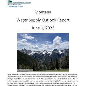
Faster than normal snowmelt during May resulted in a decrease in snowpack percentages from last month and the seasonal snowpack at many monitoring stations melted out earlier than normal. The snowpack only remains at the highest elevations across Montana. While much of the seasonal snow has melted, the total volume of snow water equivalent accumulated this year was near to above normal in all but part of northwest Montana and the northern Rocky Mountain Front. Last month’s rapid snowmelt resulted in reduced water supply forecasts for the summer at most stream gages. Given the quick melt, a normal amount of precipitation over the next several months will be necessary to sustain normal streamflows late into the summer.
Archived Water Supply Outlook Reports
Montana Water Supply Outlook Reports from 2012 to present are available from the online directory, Montana Field Office Technical Guide.
Field Office Technical Guide
To view an archived report, select "Section 2 - Natural and Cultural Resources Information", "Climatic Data", "2. Snow Survey", then select a water year of interest.