
Water Supply - Idaho
What is the Water Supply Outlook Report?
Water Supply Outlook Reports (WSOR) are published each month from January through June. The report contains both statewide and watershed-specific assessments of the winter snowpack compared to the historical normals, reservoir storage, streamflow forecasts and many other useful insights into water supply conditions. This product is accessible via the Idaho Snow Survey webpage or by subscribing to an email delivery service.
Historical Water Supply Outlook Reports
Streamflow Seasonal Forecasts
What is the SWSI?
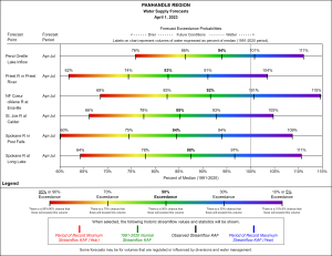
A Surface Water Supply Index (SWSI) is a predictive indicator of the surface water available in a basin compared to historic supply. The SWSI is calculated by summing the two major sources of irrigation water supply; reservoir carryover and spring and summer streamflow runoff. These two sources are analyzed together when determining the total surface water supply available for the season.
Snow Water Equivalent (SWE) - What is it and how do we use it?
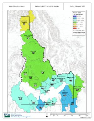
An important term to describe the relationship between snowpack depth and water supply is called "snow water equivalent," or SWE for short. Snow water equivalent describes how much water is contained within the snowpack. If you imagine filling a pot with snow from your backyard and melting it, the amount of water left in the pot is how much water (SWE) was contained in that amount of snow.
Snow scientist’s use snow water equivalent rather than snow depth to predict water supply because the snowpack’s water content can vary drastically depending on the local climate. For example, 12 inches of very light, dry snow that’s typically found in colder, interior regions like Montana, Utah and Colorado will contain less water when melted compared to the heavy, wet, dense snow often found in wetter, warmer climates like the Sierra Mountains, Western Washington and Oregon.