Automated Soil Climate Monitoring: SCAN
The National Water and Climate Center administers a pilot soil climate monitoring program consisting of automated data collection sites across the U.S.
The Soil Climate Analysis Network (SCAN) began as a soil moisture/soil temperature pilot project of the Natural Resources Conservation Service in 1991. The system is designed to provide data to support natural resource assessments and conservation activities. More recently, the Tribal Soil Climate Analysis Network (Tribal SCAN) was developed to support similar activities on Tribal lands across the U.S.
The SCAN system focuses on agricultural areas of the U.S. and is composed of over 200 stations. A typical SCAN site monitors soil moisture content at several depths, air temperature, relative humidity, solar radiation, wind speed and direction, liquid precipitation, and barometric pressure. More about SCAN sensors.

SCAN automated data collection site
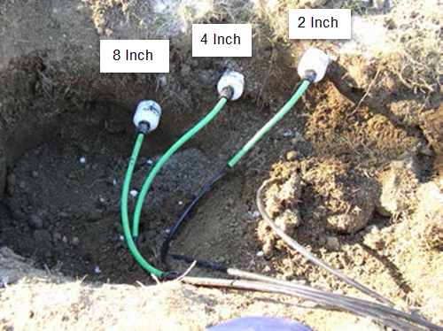
Soil moisture and temperature sensors at a SCAN site. Standard depths are 2, 8, and 20 inches. Optional depths are 4 and 40 inches.
Telemetry and Data Transmission
Data at SCAN sites are collected hourly and stored by a datalogger installed in an electronics enclosure. Depending on the location of the site, data are transmitted back to the Water and Climate Information System using one of several telemetry systems:
Cellular
Meteor Burst
Satellite (GOES, Iridium)
More Information
SCAN Products
SCAN Brochure
Tribal SCAN Brochure
National Soil Survey Center
Texas A&M University North American Soil Moisture Database

