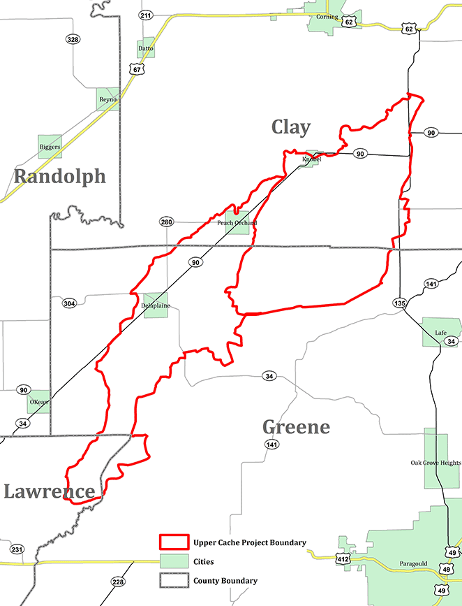
The Upper Cache River Watershed Mississippi River Basin Healthy Watersheds Initiative (MRBI) Project is a voluntary program that provides financial and technical assistance to agricultural producers for addressing water quality concerns in the Petersburg Ditch-Cache River and Big Gum Lateral-Cache River watersheds in portions of Clay, Greene and Lawrence counties. The project area covers 54,025 acres.
Resource Concerns Addressed by the Project
Water Quality Degradation - Excessive nutrients in surface and ground waters (primary)
Water Quality Degradation – Excessive sediment in surface water (primary)
Water Quantity – Inefficient Use of Irrigation (secondary)
Inadequate Habitat for Fish and Wildlife - Habitat degradation (secondary)
Project Goals
Reduce soil loss in the watershed to improve water quality in a segment of the Upper Cache River.
Voluntarily implement a systems approach of conservation practices to reduce nutrient and sediment by 2018 in target acres.
The documented water savings for basic irrigation water management and associated supporting practices will be 10-25 percent.
Conservation Practice Funding
Funding will be available to eligible landowners through the Environmental Quality Incentives Program (EQIP). NRCS will provide financial assistance for a systems approach using approved conservation practices for the purpose of addressing resource concerns. Land and producer eligibility, adjusted gross income, and all other program criteria for participation must be met to participate in this initiative. Agricultural lands are eligible for enrollment in the initiative.
Approved Conservation Practices
Core Practices
328 - Conservation Crop Rotation
340 - Cover Crop
342 - Critical Area Planting
390 - Riparian Herbaceous Buffer
391 - Riparian Forest Buffer
436 - Irrigation Reservoir
443 - Irrigation System-Surface and Subsurface
449 - Irrigation Water Management
590 - Nutrient Management
612 - Tree/Shrub Establishment
Supporting Practices
345 - Residue & Tillage Management-Reduced Till
410 - Grade Stabilization Structure
430 - Irrigation Pipeline
464 - Irrigation Land Leveling
484 - Mulching
490 - Tree/Shrub Site Preparation
533 - Pumping Plant
587 - Structure for Water Control
607 - Surface Drain - Field Ditch
608 - Surface Drain - Main and Lateral
644 - Wetland Wildlife Habitat Management
646 - Shallow Water Development and Management
Partners
Clay County Conservation District
Greene County Conservation District
Lawrence County Conservation District
Arkansas Natural Resource Commission
Arkansas Game and Fish Commission
Arkansas Forestry Commission
Arkansas State University
University of Arkansas Cooperative Extension Service
Legacy Agricultural Equipment
Local Drainage Districts
The Nature Conservancy
How to Apply for MRBI
NRCS and associated conservation partners will deliver this program collaboratively. Applications may be obtained and filed with NRCS at:
Clay County
Piggott Field Service Center
168 E. Main St.
Piggott, AR 72454
(870) 598-2287, ext. 3
Greene County
Paragould Field Service Center
206 N. Rockingchair Rd.
Paragould, AR 72450
(870) 239-8586, ext. 3
Lawrence County
Walnut Ridge Field Service Center
1100 W. Main
Walnut Ridge, AR 72476
(870) 886-7791, ext. 3


 Overview