
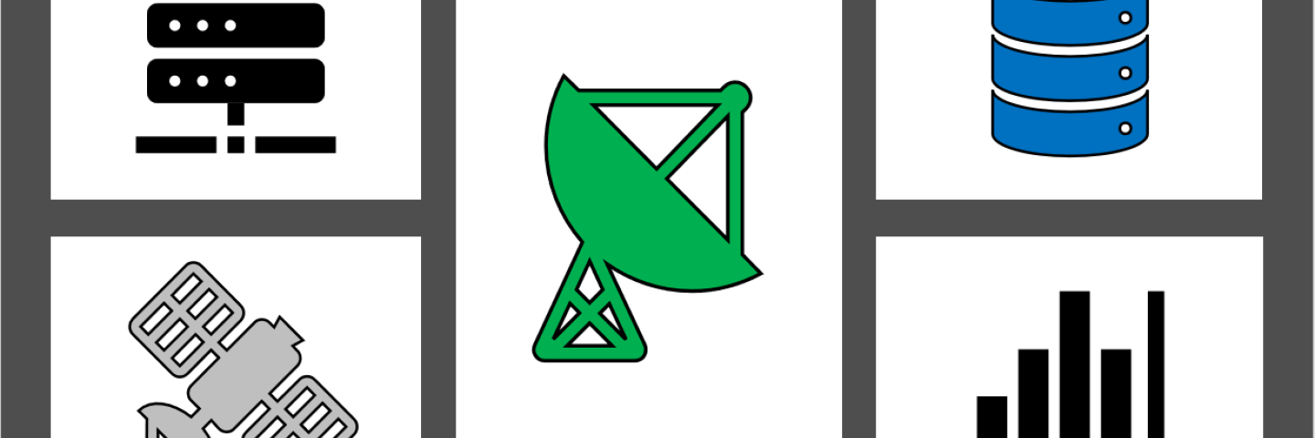
The National Water and Climate Center manages big data from thousands of climate stations and manual data collection sites across North America, and makes that data available to the public.
The Water and Climate Information System, usually referred to as WCIS, supports thousands of users and trillions of dollars of economic value every year. WCIS is comprised of the databases, applications, and tools which support the extensive data collection network of the Snow Survey and Water Supply Forecasting (SSWSF) Program and the Soil Climate Analysis Network.
Snow data are collected at automated Snow Telemetry (SNOTEL) sites or manually-measured snow courses in the West. Soil climate data are collected at automated Soil Climate Analysis Network (SCAN) sites throughout the U.S. Data are transmitted either to intermediate Master Stations or directly back to the centralized database servers, which are located in a secure, fail-safe environment.
The WCIS database also ingests precipitation, streamflow, and reservoir data from the U.S. Army Corps of Engineers (USACE), the U.S. Bureau of Reclamation (BOR), the Applied Climate Information System (ACIS), the U.S. Geological Survey (USGS), various water districts and other entities.
All of the data collected are made publicly available as charts, graphs, maps, reports, and even in raw form.
Data Collection and Telemetry
Manual Snow Measurements
As part of the Snow Survey and Water Supply Forecasting (SSWSF) Program, the National Water and Climate Center (NWCC) administers a manual snow monitoring program for the western U.S. Manual monitoring consists of monthly snow course measurements and aerial marker observations of mountain snowpack. Map: Snow Courses and Aerial Markers
Snow Courses
Snow courses are locations where manual snow measurements are taken during the winter season to determine the depth and water content of the snowpack. Snow courses are permanent locations and represent the snowpack conditions at a given elevation in a given area.
Generally, snow courses are about 1,000 feet (300 meters) long and are situated in small meadows protected from the wind. They consist of a variable number of individual sample points, typically 5 to 10, which are evenly-spaced between points.
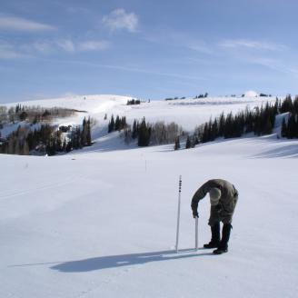
Snow surveyors travel to snow courses using skis, over-snow machines, or helicopters. Once onsite, the surveyors use snow samplers at each sample point to measure the depth of the snowpack and then weigh the snow to determine the snow water equivalent. The data collected are then entered into the Water and Climate Information System database.

A surveyor uses a snow tube at a sample point on a snow course to measure the snowpack depth and water equivalent. The remote location of this snow course requires the use of a helicopter.
Historically, snow course measurements were the first form of snowpack data collection, starting in 1906 when Dr. James Church from the University of Nevada measured a course he laid out on Mt. Rose near Reno. Prior to the 1970s and the inception of the automated Snow Telemetry (SNOTEL) network, snow courses were the primary means of collecting snowpack data. As a result, snow course data records often start earlier than SNOTEL records.
Aerial Markers
Aerial markers are used to measure the depth of snow. Surveyors then use an estimated density to calculate snow water equivalent. The markers are located in remote locations that are difficult to reach by over-snow travel. They consist of one measuring point marked by a pipe with cross members that can be easily observed by aircraft flyover.

Harts Pass aerial marker, Washington
Snow Sampler
A snow sampler (also known as Federal snow sampler) is a device that measures snow water equivalent (SWE). Snow samplers consist of an aluminum snow tube and a spring scale.
Snow depth is measured by pushing the tube down through the snowpack to the ground surface and then extracting a core. One surveyor measures the snow depth while the other surveyor records data. From 5 to 10 measurements are taken at regular intervals along a snow course.

Extracting a core sample of the snowpack using a snow tube.
In taking an accurate snow core sample, the surveyor must verify that the tube has reached ground level by examining the base of the tube and finding soil. After clearing the soil from the tube, the surveyor then determines the amount of water in the snowpack by weighing the tube with its snow core and subtracting the weight of the empty tube. An average of all samples taken is calculated and used to represent that snow course.

Using a snow sampling scale to measure snow water equivalent of mountain snowpack.

Automated Snow Monitoring
As part of the Snow Survey and Water Supply Forecasting (SSWSF) Program the National Water and Climate Center administers an automated snow monitoring program consisting of several types of automated and semi-automated data collection methods.
Snow Telemetry (SNOTEL) Network
The SNOTEL network is composed of over 900 automated data collection sites located in remote, high-elevation mountain watersheds in the western U.S. They are used to monitor snowpack, precipitation, temperature, and other climatic conditions. The data collected at SNOTEL sites are transmitted to a central database, called the Water and Climate Information System, where they are used to make water supply forecasts.
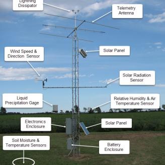
SNOTEL sites are designed to operate unattended and without maintenance for a year or more. A typical SNOTEL remote site consists of measuring devices and sensors, an equipment shelter for the radio telemetry equipment, and an antenna that also supports the solar panels used to keep batteries charged.
A standard sensor configuration includes a snow pillow, a storage precipitation gage, and a temperature sensor. The snow pillow measures how much water is in the snowpack by weighing the snow with a pressure transducer. Automatic measuring devices in the shelter house convert the weight of the snow into an electrical reading of the snow's water equivalent -- that is, the actual amount of water in a given volume of snow.
SNOTEL stations also collect data on snow depth, all-season precipitation accumulation, and air temperature with daily maximums, minimums, and averages. Many enhanced SNOTEL sites are equipped to take soil moisture and soil temperature measurements at various depths, as well as solar radiation, wind speed, and relative humidity. The configuration at each site is tailored to the physical conditions, the climate, and the specific requirements of the data users.
The data collected at SNOTEL sites are generally reported multiple times per day, with some sensors reporting hourly.
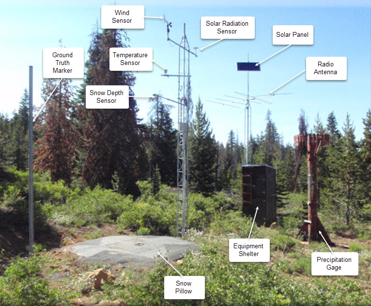
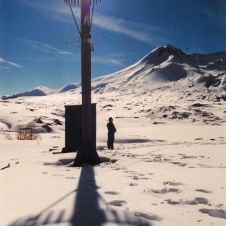
SNOTEL automated data collection site
Snolite Network
Since the early days of the snow survey program, aerial markers have been used to measure snowpack in very remote areas where accessibility is limited.
In the last few years, some aerial markers have been outfitted with basic sensors, such as temperature and snow depth, and telemetered using the Iridium Satellite System. Aerial markers with these sensors are called Snolite sites.
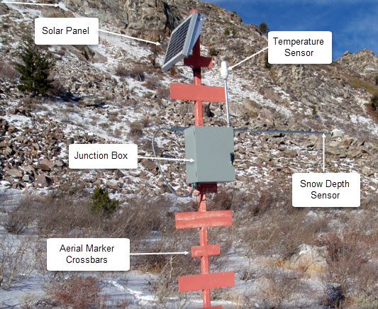
Snolite automated aerial marker
Automated Soil Climate Monitoring
The SCAN Program utilizes similar equipment and technologies, and the data collected feeds into the same database. Learn more about SCAN.
Data Transmission and Telemetry
Data at SNOTEL, Snolite, and SCAN sites are collected and stored by a datalogger installed in the equipment shelter or enclosure. Depending on the location of the site, data are transmitted back to the Water and Climate Information System using one of the following telemetry systems.
Meteor Burst
Most of the SNOTEL network uses meteor burst communication technology to send and receive data in near real-time. Each SNOTEL site transmits a radio signal into the sky, and this signal bounces off a band of ionized meteorites existing about 50 to 80 miles above the earth. This technique allows communication to take place between remote sites and a master station up to 1200 miles away.
At the master station, the remote site data are checked for completeness. If complete, an acknowledgment message, returning over the same path, tells the remote site not to transmit again during this polling period. The entire process takes less than a tenth of a second.

Meteor burst communication system
Cellular
In a cellular network, signals carrying voice, text, and digital data are transmitted via radio waves through a global network of transmitters and receivers. Signals are distributed over land through cells, where each cell includes a fixed location transceiver known as a base station.
The Soil/Climate Analysis Network (SCAN) uses cellular data transmission for many sites, especially in the eastern U.S. Cellular modems installed in the electronics enclosure transmit data back to the Water and Climate Information System database.
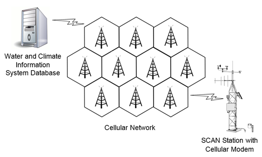
Cellular network
Satellite
GOES
The Geostationary Operational Environmental Satellite (GOES) system is operated by the U.S. National Environmental Satellite, Data, and Information Service. The system supports weather forecasting, severe storm tracking, and meteorology research. The system is currently composed of two geostationary satellites, GOES-East and GOES-West. SNOTEL, Snolite, and SCAN sites with GOES transmitters send data to the GOES-West satellite, where they are then transmitted back to a receiver station. Once received, the data are converted to meteor burst format and incorporated into the Water and Climate Information System.
Iridium
Similar to the GOES system, the Iridium Satellite System consists of a network of 66 cross-linked satellites, which operate in near-circular low-Earth orbits (LEOs) about 480 miles (772 kilometers) above the Earth’s surface. Each satellite can project 48 spot beams on the Earth’s surface, and the satellites are cross-linked so that each satellite can “talk” with other nearby satellites.
Much like a cellular network where data are transmitted via multiple cellular towers, the Iridium Satellite System data are relayed from satellite to satellite until they are downlinked at an Iridium gateway and then transmitted to the Water and Climate Information System database.

Iridium Satellite System
How to Access Snow and Water Data
Snow and Water Interactive Map
Welcome to the National Water and Climate Center's Snow and Water Interactive Map, a groundbreaking tool designed to provide farmers, researchers, policymakers, and water management professionals with up-to-the-minute snow survey data and water supply forecasting.
Learn MoreAWDB Web Service Tool
The AWDB (Air-Water Database) Web Service provides methods for programmatically accessing data, metadata (elements, units, stations, etc.), 30-Year Normals, and water supply forecasts.
Report Generator
Report Generator is a web application that uses uses long-term snowpack, precipitation, reservoir, streamflow, and soils data from a variety of quality-controlled sources to create reports.
Water Supply Forecast Charts
The Water Supply Forecast tool creates regional water supply forecast exceedance probability charts.