
North Branch Park River Watershed
Sponsor: Park River Joint Water Resource District
DRAFT WATERSHED PLAN - ENVIRONMENTAL IMPACT STATEMENT (EIS) NORTH BRANCH PARK RIVER WATERSHED, CART CREEK SITE 1
The purposes of the proposed action are flood damage reduction and watershed protection.
The North Branch Park River Watershed incurs $1,733,000 in average annual flood damage as a result of 4,485 acres of cropland inundation and damage to roads, buildings, and other property. The 100-year flood inundates 136 structures, including the community of Crystal, ND. The watershed annually contributes 36,412 lbs of phosphorus and 197,533 lbs of nitrogen to the Red River, for which U.S. agreed to nutrient objectives at the international border have not been achieved. Historic loss of wetland and upland habitat within the Red River Basin threatens multiple species.
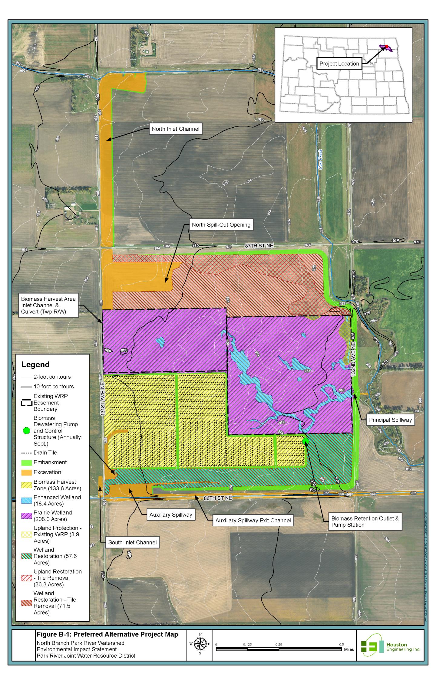
The Preferred Alternative entails construction of a multi-purpose, off-channel, dry dam with a drainage area of 33.8 square miles, embankment length of 2.6 miles, maximum height of 17.3 feet, and average height of 9.7 feet. The dam will provide 2,593 acre-feet of temporary flood storage at the auxiliary spillway crest elevation and inundate 466-acres for a duration of less than a week during flood events. The dam will be classified as a high hazard dam due to downstream structures. Within the temporary flood pool, 134 acres of shallow retention cells will be constructed and managed via water control and biomass harvest for removal of incoming nutrient loads. The project will result in restoration of 284 acres of wetlands, enhancement of 16 acres of existing wetlands, and enhancement of 52 acres of upland wildlife habitat.
Total Installation Cost: $12,228,700
Federal (NRCS) Contribution: $9,661,000
Current Status
Comments received from the 2023 scoping period were addressed in the Final Draft Plan- EIS and Appendices. A public in-person meeting was held on December 12, 2023 in Cavalier, ND to review the final Draft Plan - EIS. All stakeholders including affected landowners, federal, state and local agencies and applicable tribal governments were invited to the Public Meeting and invited to comment on the Draft Plan EIS. The Notice of Availability of the Final Draft Plan EIS, was sent to the U. S. EPA and published in the Federal Register on 12/1/2023. The Final Draft Plan - EIS comment period concluded on 1/26/2024. Section 106 Consultation has been completed.
Link to Feb 23, 2023 Scoping Meeting: