
Long-term Research Project in Indiana Shows Conservation Farming can Improve Water Quality

Indiana NRCS partnered with researchers at IUPUI to study water quality in a portion of the Upper White River Watershed known as School Branch.
By Brandon O'Connor, Public Affairs Specialist, USDA-NRCS, Indianapolis
Robert Barr admits his research team started with a project scope that was nearly impossible to accomplish. Barr, a research scientist in the Center for Earth and Environmental Science at Indiana University–Purdue University Indianapolis (IUPUI), set out 16 years ago to study the water quality in the Upper White River Watershed.
The watershed encompasses more than 2,700 square miles and stretches across 16 counties near Indianapolis, Indiana. Water quality is important in the watershed because it provides the drinking water for multiple major urban areas including Indianapolis, Muncie and Anderson, Indiana. But Barr said they quickly realized the scope of the project didn’t allow for detailed research, so they downsized the study to focus on the Eagle Creek watershed located just outside of Indianapolis and a major drinking water source for the state capital.
At only 162 square miles, the new project was, “an order of magnitude smaller,” Barr said, but the research team still struggled to accomplish its goals. Problems such high nitrogen or phosphorous levels as well as excess sediment had led to algal blooms and high chemical levels in the Eagle Creek Reservoir where the watershed drained. Researchers would go out to the watershed on a monthly and sometimes weekly basis to collect water samples, but no matter the amount of data they amassed they could not identify the causes of the water quality issues in the area.
So, once again they downsized. The project that had once focused on a more than 2,700 square mile area was ultimately hyper-focused onto an eight and a half square mile sub-watershed known as School Branch, with a nine-mile creek bearing the same name flowing through it before draining into the reservoir.
“That allowed us to really understand who was doing what,” Barr said. “So, if we saw something in the water quality measurements, we could ask, ‘What were you doing on this date,’ and we will get responses. We knew almost everybody along the river. We could walk the whole creek in a day. So, we could understand where sediment sources might be. We could understand who was doing what in one field, or we could understand if a new housing area had gone up.”
The School Branch project expanded in 2014-15 when the watershed was designated as a National Water Quality Initiative watershed (NWQI) by USDA’s Natural Resources Conservation Service (NRCS). NWQI is a partnership between the NRCS and the U.S. Environmental Protection Agency (EPA) at the federal level and the NRCS and Indiana Department of Environmental Management (IDEM) at the state level.
The NWQI designation of School Branch, and the Upper White River Watershed as a whole, unlocked additional funding for monthly water quality monitoring through IDEM. The project also received funding for continuous monitoring through the NRCS’ Environmental Quality Incentives Program (EQIP), enabling the installation of edge-of-field monitoring stations on two fields in the School Branch watershed.
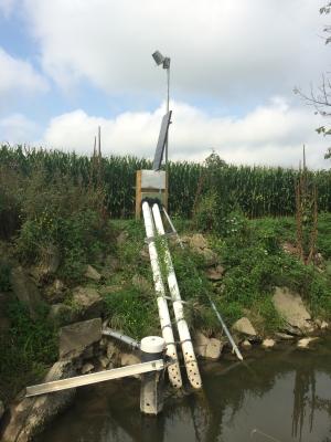
Edge-of-field stations enable researchers to collect real time data as water from surface runoff and tile systems, which are pipes installed under agriculture fields to help with drainage, flows into the School Branch Creek that drains into Eagle Creek Reservoir.
The fields where the edge-of-field monitors were installed and the surrounding fields are managed by long-time conservation farmers who practice soil health measures such as no-till farming, the planting of cover crops in fallow periods in-between cash crop growing seasons, precision nutrient management and stream buffers. The farms, owned by Mike Starkey and Jack Maloney, are located in the southern portion of the watershed. The farms north of them where the School Branch Creek originates historically managed their fields, “in more of a traditional Indiana way with conservation and conventional tillage but without cover crops,” said Indiana NRCS State Resource Conservationist Shannon Zezula.
That set-up created the perfect research opportunity. The quality of the water flowing in the creek could be measured as it entered Starkey and Maloney’s property. Then it can be compared to the water draining from their fields as well as the quality of the water in the School Branch Creek once it exited their land and continued on into Eagle Creek Reservoir.
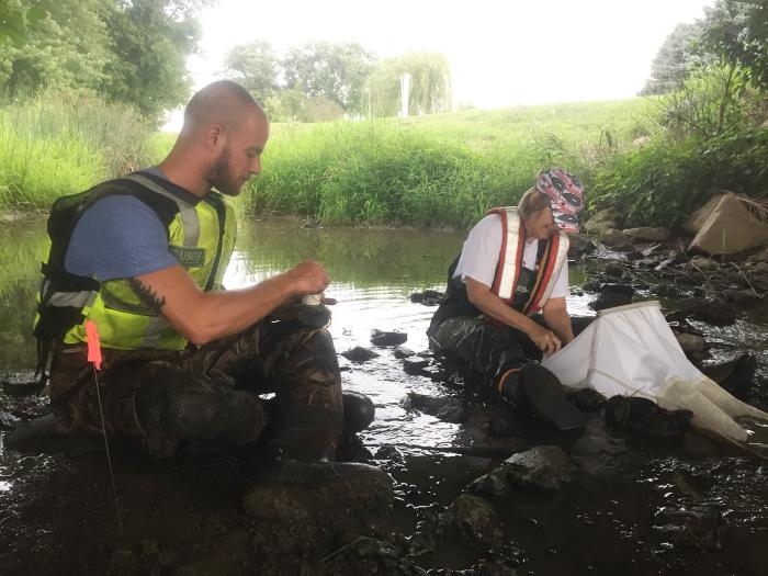
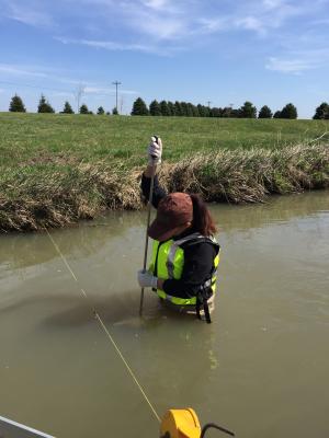
To collect the needed data, the NRCS and IUPUI, which manage the edge-of-field monitors, partnered with the United States Geological Survey (USGS) and IDEM to install nutrient supergages in the School Branch Creek at two sites. These nutrient supergages monitor water-quality parameters including nutrients in real time. One gage was installed in 2015 downstream of Starkey and Maloney’s farms where the water exits their fields and continues flowing toward Eagle Creek Reservoir. A second nutrient supergage was installed in 2018 upstream from Starkey and Maloney’s farm to measure the water quality entering their field after passing through land historically managed without cover crops and with tillage.
In the nearly six years since, the supergages have automatically taken a water quality reading from the creek every 15 minutes. Unlike the weekly or monthly water quality testing IUPUI was originally doing in the watershed, the supergages have given them real time data 96 times a day, every day for nearly six years.
“We can go out there and take water quality samples, but we can't be out there every 15 minutes taking that depth sample,” said Aubrey Bunch, a hydrologist for USGS and the agency’s project chief since 2016. “Because it's such a small stream, it's very flashy, it changes quickly. So, the sediment or the nutrient concentrations can change within an hour or two if a storm rolls through. With that 15-minute data, we can actually see spikes that we would have otherwise missed.”
The real time data from the nutrient supergages can be related to additional water-quality samples and enabled researchers to build models that allow them to approximate continuous measurements of total nitrogen, total phosphorous and total suspended sediment solids in the water. The models are important as those data points cannot be measured directly by the supergage.
And, after nearly six years of data collection, researchers have found a potential golden goose that may prove once and for all the effectiveness of soil health practices such as cover crops and no-tillage.
“One of the things that we have been able to do in the School Branch watershed that really is a first is to document that the quality of the water coming off of Mike (Starkey)'s fields was actually a better quality than the receiving water in School Branch many times,” Barr said. “That is completely counter to conventional wisdom that said, these tiles are always the hotspots and we're always going to see the nutrient coming up, but actually it is substantially lower coming off these farm fields managed for soil health.”
The research location was “perfect” Barr said, because the creek flows from traditionally-managed fields into fields that are mature systems where soil health principles have been fully implemented for a number of years. The relationships with the farmers in the watershed have also been key because they will contact the researchers before making changes to the land, enabling the researchers to track the impact of planting, harvesting, crop rotations, nutrient application and more.
“We couldn't have designed a better experiment and we have found we can't easily replicate it,” Barr said. “What we wanted to do is just (what this site offers). What is coming in from upstream, and how does that change when it comes to Mike's farm and what do we see coming off of Mike's field?”
The final results of the study have not been published and are still being compiled by IUPUI, NRCS, IDEM, USGS and other partners involved in the project such as the Marion County Health Department, Indiana Geological and Water Survey, and the Indiana Soybean Alliance. Preliminary results show that the conservation practices are having a positive impact on water quality.
“What we find is that the nutrients coming off the farms with cover crops and no-till are very low,” Zezula said. “The water in the stream above that has higher nutrient content. Then as it flows downstream, it kind of dilutes through these farmers' drainage and the water is lower in nutrients. So, we're showing that these systems are good for water quality and they're good for agricultural production and the two can coexist together.”
The monitoring of the site is still ongoing for one more year, but if the results hold true, agencies like the NRCS will have another feather in their hat when talking to farmers about the benefits of practices that lead to improved soil health. Not only will they be able to pitch them as having the potential to trap nutrients and improve yields, but they can use data to show the practices can play a role in improving downstream water quality.
Additional Information
Indiana Special Initiatives
NRCS uses Landscape Conservation Initiatives to accelerate the benefits of voluntary conservation programs, such as cleaner water and air, healthier soil and enhanced wildlife habitat.
Learn MoreEnvironmental Quality Incentives Program - Indiana
The Environmental Quality Incentives Program (EQIP) provides financial and technical assistance to agricultural producers and non-industrial forest managers to conserve natural resources while strengthening their operations.
Learn MoreINDIANA NRCS HOMEPAGE
For more information about NRCS programs offered in Indiana and how experts throughout the state can help you address natural resource concerns on your land, visit the Indiana NRCS homepage.