
DUBUQUE SERIES
LOCATION IA+IL MN WI
Established Series
Rev. ECS-LDC-TWN
07/2004
The Dubuque series consists of moderately deep, well drained soils formed in 46 to 91 centimeters (18 to 36 inches) of loess and a thin layer of residuum from limestone bedrock or reddish paleosol high in clay overlying limestone bedrock. These soils are on ridges of narrow interfluves and side slopes on uplands and high structural benches. Slopes range from 2 to 60 percent. Mean annual air temperature is about 8 degrees C (47 degrees F). Mean annual precipitation is about 84 centimeters (33 inches).
TAXONOMIC CLASS: Fine-silty, mixed, superactive, mesic Typic Hapludalfs
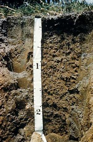
TYPICAL PEDON: Dubuque silt loam, on a north-facing, convex 10 percent slope, in a pasture with scattered trees. (Colors are for moist soil unless otherwise stated.)
A--0 to 8 centimeters (0 to 3 inches); very dark gray (10YR 3/1) with some dark grayish brown (10YR 4/2) silt loam, gray (10YR 6/1) dry; moderate fine granular structure grading to weak thin platy in the lower part; friable; few prominent light gray (10YR 7/1) clean silt and sand grains on surfaces of platy structure; common fine roots; slightly acid; abrupt smooth boundary. [5 to 10 centimeters (2 to 4 inches) thick]
E1--8 to 20 centimeters (3 to 8 inches); dark grayish brown (10YR 4/2) silt loam; moderate thin platy structure; friable; many prominent light gray (10YR 7/1) clean silt grains on faces of peds; few fine roots; slightly acid; clear smooth boundary.
E2--20 to 28 centimeters (8 to 11 inches); brown (10YR 5/3) silt loam; weak thin platy structure; friable; few prominent light gray (10YR 7/1) coatings of silt grains on faces of peds; moderately acid; clear smooth boundary. [Combined thickness of the E horizon is 10 to 25 centimeters (4 to 10 inches).]
BE--28 to 41 centimeters (11 to 16 inches); yellowish brown (10YR 5/4) silt loam, faces of peds brown (10YR 5/3); weak fine subangular and angular blocky structure; friable; few prominent light gray (10YR7/1) coatings of silt grains on faces of peds; moderately acid; clear smooth boundary. [0 to 25 centimeters (0 to 10 inches) thick]
Bt1--41 to 56 centimeters (16 to 22 inches); yellowish brown (10YR 5/4) silty clay loam; moderate fine angular and subangular blocky structure; friable; few distinct brown (10YR 4/3) clay films on faces of peds; few prominent light gray (10YR 7/1) coatings of silt grains on faces of peds; moderately acid; abrupt wavy boundary. [15 to 38 centimeters (6 to 15 inches) thick]
2Bt2--56 to 69 centimeters (22 to 27 inches); brown (7.5YR 4/4) clay; moderate fine and medium angular and subangular blocky structure; very firm; many distinct dark brown (7.5YR 3/2) clay films; few reddish brown (5YR 4/4) and yellowish red (5YR 4/6) coatings on faces of peds; few small chert fragments; moderately acid; abrupt wavy boundary. [2 to 10 centimeters (1 to 5 inches) thick]
2R--69 centimeters (27 inches); less than 2 centimeters (1 inch) of soft very pale brown (10YR 7/3) fragmented limestone over hard level bedded limestone. Some of the limestone fragments can be separated and have small amounts of reddish clayey material between them.
TYPE LOCATION: Major Land Resource Area (MLRA) 105; Dubuque County, Iowa; about 2 miles east of Holy Cross; about 2395 feet south and 1,160 feet west of the northeast corner sec. 22, T. 90 N., R. 1 W.; USGS Holy Cross quadrangle; lat. 42 degrees 35 minutes 43.8 seconds N. and long. 90 degrees 56 minutes 30.3 seconds W., NAD 83.
RANGE IN CHARACTERISTICS:
Depth to lithic contact of dolomitic limestone--51 to 102 centimeters (20 to 40 inches)
Content of clay in the particle-size control section (weighted average)--26 to 35 percent
Content of sand in the particle-size control section (weighted average)--less than 10 percent
A or Ap horizon:
Hue--10YR
Value--3 to 5
Chroma--1 to 3
Texture--silt loam or silty clay loam
Clay content--15 to 32 percent
Reaction--strongly acid to neutral
E horizon:
Hue--10YR
Value--4 or 5
Chroma--2 or 3
Texture--silt loam or silty clay loam
Clay content--15 to 27 percent
Reaction--strongly acid to neutral
Bt horizon:
Hue--10YR
Value--4 or 5
Chroma--3 to 6
Texture--silt loam or silty clay loam
Clay content--26 to 35 percent
Reaction--strongly acid to slightly acid
2Bt horizon:
Hue--5YR, 7.5YR, or 10YR
Value--4 to 6
Chroma--3 to 8
Texture--silty clay or clay
Clay content--40 to 55 percent
Reaction--strongly acid to slightly acid
Rock fragment content--2 to 15 percent chert or limestone
COMPETING SERIES: These are the Baraboo, Bertrand, Blackhammer, Camden, Dodge, Fayette, Flagg, Greenridge, Hackers, Jackson, Jemerson, La Farge, Lambeau, Martinsburg, Menfro, Middletown, Navlys, Palermo, Palsgrove, Pepin, Piscasaw, Ridgeway, Rozetta, Ruma, Rush, Russell, Seaton, St. Charles, Stookey, Sylvan, Thebes, and Yellowriver series.
Baraboo--have a lithic contact of quartzite within a depth of 51 to 102 centimeters (20 to 40 inches) and do not have a layer of clayey residuum or reddish palesol in the lower third of the series control section
Bertrand--do not have a lithic contact within a depth of 51 to 102 centimeters (20 to 40 inches)
Blackhammer--do not have a lithic contact within a depth of 51 to 102 centimeters (20 to 40 inches)
Camden--do not have a lithic contact within a depth of 51 to 102 centimeters (20 to 40 inches)
Dodge--do not have a lithic contact within a depth of 51 to 102 centimeters (20 to 40 inches)
Fayette--do not have a lithic contact within a depth of 51 to 102 centimeters (20 to 40 inches)
Flagg--do not have a lithic contact within a depth of 51 to 102 centimeters (20 to 40 inches)
Greenridge--do not have a lithic contact within a depth of 51 to 102 centimeters (20 to 40 inches)
Hackers--do not have a lithic contact within a depth of 51 to 102 centimeters (20 to 40 inches)
Jackson--do not have a lithic contact within a depth of 51 to 102 centimeters (20 to 40 inches)
Jemerson--do not have a lithic contact within a depth of 51 to 102 centimeters (20 to 40 inches)
La Farge--have a paralithic contact of glauconitic sandstone within a depth of 51 to 102 centimeters (20 to 40 inches) and have a clay content of 18 to 27 percent in the particle-size control section
Lambeau--do not have a lithic contact within a depth of 51 to 102 centimeters (20 to 40 inches)
Martinsburg--do not have a lithic contact within a depth of 51 to 102 centimeters (20 to 40 inches)
Menfro--do not have a lithic contact within a depth of 51 to 102 centimeters (20 to 40 inches)
Middletown--do not have a lithic contact within a depth of 51 to 102 centimeters (20 to 40 inches)
Navlys--do not have a lithic contact within a depth of 51 to 102 centimeters (20 to 40 inches)
Palermo--do not have a lithic contact within a depth of 51 to 102 centimeters (20 to 40 inches)
Palsgrove--have a lithic contact of dolomitic limestone within depths of 102 to 152 centimeters (40 to 60 inches) and have a clay content of 27 to 35 percent in the particle-size control section
Pepin--have a lithic contact of dolomitic limestone within depths of 114 to 203 centimeters (45 to 80 inches) and have a clay content of 18 to 27 percent in the particle-size control section
Piscasaw--do not have a lithic contact within a depth of 51 to 102 centimeters (20 to 40 inches)
Ridgeway--do not have a lithic contact within a depth of 51 to 102 centimeters (20 to 40 inches)
Rozetta--do not have a lithic contact within a depth of 51 to 102 centimeters (20 to 40 inches)
Ruma--do not have a lithic contact within a depth of 51 to 102 centimeters (20 to 40 inches)
Rush--do not have a lithic contact within a depth of 51 to 102 centimeters (20 to 40 inches)
Russell--do not have a lithic contact within a depth of 51 to 102 centimeters (20 to 40 inches)
Seaton--do not have a lithic contact within a depth of 51 to 102 centimeters (20 to 40 inches)
St. Charles--do not have a lithic contact within a depth of 51 to 102 centimeters (20 to 40 inches)
Stookey--do not have a lithic contact within a depth of 51 to 102 centimeters (20 to 40 inches)
Sylvan-- do not have a lithic contact within a depth of 51 to 102 centimeters (20 to 40 inches)
Thebes-- do not have a lithic contact within a depth of 51 to 102 centimeters (20 to 40 inches)
Yellowriver--do not have a lithic contact within a depth of 51 to 102 centimeters (20 to 40 inches)
GEOGRAPHIC SETTING:
Parent material--46 to 91 centimeters (18 to 36 inches) of loess and a thin layer of residuum from limestone bedrock or reddish paleosol high in clay
Landform--ridges of narrow interfluves and side slopes on uplands and high structural benches
Slopes--2 to 60 percent
Elevation--183 to 427 meters (600 to 1400 feet) above sea level
Mean annual air temperature--7 to 10 degrees C (45 to 50 degrees F)
Mean annual precipitation--81 to 89 centimeters (32 to 35 inches)
Frost-free period--145 to 180 days
GEOGRAPHICALLY ASSOCIATED SOILS: These are Fayette, Nordness, Rollingstone, and Rozetta soils.
Fayette--are at higher elevations on interfluves and side slopes and do not have a lithic contact within the series control section
Nordness--are at lower elevations on side slopes and have a lithic contact within depths of 20 to 51 centimeters (8 to 20 inches)
Rollingstone--are in landscape positions similar to those of the Dubuque soils and have a clay content of 60 to 80 percent in the lower half of the series control section
Roxetta--are at lower elevations on base slopes, do not have a lithic contact within the series control section, and have a saturated zone with depths of 1.2 to 1.8 meters (4 to 6 feet) in February to April in normal years
DRAINAGE AND PERMEABILITY:
Drainage class--well drained--saturation does not occur within a depth of 1.8 meters (6 feet) during the wettest periods of normal years
Saturated hydraulic conductivity--moderately high in the loess, moderately low in clayey residuum, and low to moderately high in the limestone bedrock depending on the amount of weathered rock
Surface runoff potential--low to high
USE AND VEGETATION:
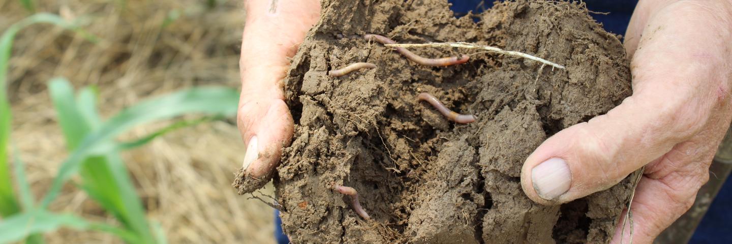
Nearly level to gently sloping areas are cultivated. The principal crops are corn, soybeans, small grains, and legume hays. Steeper slopes are pastured, wooded or both wooded and pastured. The native vegetation is deciduous trees.
DISTRIBUTION AND EXTENT:
Physiographic Division--Interior Plains
Physiographic Province--Central Lowland
Physiographic section(s)--Eastern lake section, Wisconsin driftless section, Dissected till plains, Till plains
MLRA(s)--Southern Wisconsin and Northern Illinois Drift Plain (95B), Eastern Iowa and Minnesota Till Prairies (104), Northern Mississippi Valley Loess Hills (105), and Illinois and Iowa Deep Loess and Drift (108)
LRR M and LRR L; northeastern Iowa, southeastern Minnesota, southwestern Wisconsin, and northwestern Illinois
Extent--large
MLRA SOIL SURVEY REGIONAL OFFICE (MO) RESPONSIBLE: St. Paul, Minnesota
SERIES ESTABLISHED: Dubuque County, Iowa, 1920.
REMARKS:
Particle-size control section--the zone from a depth of 41 to 69 centimeters (16 to 27 inches) (Bt1 and 2Bt2 horizons);
series control section--the zone from the surface to a depth of 69 centimeters (0 to 27 inches) (A, E1, E2, BE, Bt1, and 2Bt2 horizons).
Diagnostic horizons and features recognized in this pedon:
ochric epipedon--the zone from the surface to a depth of 41 centimeters (0 to 16 inches) (A, E1, E2 and BE horizons);
argillic horizon-the zone from a depth of 41 to 69 centimeters (16 to 27 inches) (Bt1 and 2Bt2 horizons);
lithic contact--the contact with limestone bedrock at 69 centimeters (27 inches);
udic moisture regime.
Cation-exchange activity class is supported by lab sample number 86IA005038, National Soil Survey Laboratory.
Taxonomy version--Keys to Soil Taxonomy, ninth edition, 2003.
ADDITIONAL DATA:
Laboratory data--National Soil Survey Laboratory, Lincoln, Nebraska pedon 86IA005038 (http://ssldata.sc.egov.usda.gov/).
National Cooperative Soil Survey
U.S.A.